Where Did The Antilles Come From?
Steven Dutch, Professor Emeritus, Natural and Applied Sciences, Universityof Wisconsin - Green Bay

Above is a pioneering reconstruction of the continents across the Atlantic before they drifted apart. Even though it was done in 1964, it's still accurate. There's only one way to reassemble a jigsaw puzzle. Note that Iceland is missing. Iceland didn't exist then but is made entirely of younger volcanic rocks. Also the tip of Brazil overlaps Africa. The African part is the Niger River Delta, which also didn't exist when the continents were together.
But what's going on in the Caribbean and Gulf of Mexico? Much of Mexico and Central America were separate pieces and not in their present positions. Florida was probably west of its present position, and most of the present Gulf of Mexico was probably occupied by Yucatan.
So what about Cuba, Hispaniola, Puerto Rico and Jamaica? They don't have any old rocks and also did not exist at this time. They are not pieces of some older continent. They have another origin entirely.
Note: this is not a complete explanation of plate tectonics, just enogh to (hopefully) explain the Antilles and especially Hispaniola.
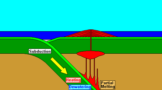
When plates converge, one descends into the earth's interior, the mantle. As it descends, it heats up. It's been soaking in sea water for millions of years and the water lowers the melting point of the adjacent mantle. Some of it melts and rises, breaking through to make a volcanic island chain. The Aleutians and Marianas are good examples. The Lesser Antilles are, too, but a bit farther along in their evolution. Where the descending plate sinks there is generally a deep, linear trough called a trench. You might naively think the deepest places in the oceans are far from land but they're actually close to land, in the trenches. Sediments erode off the volcanoes and deposit in the ocean trench.
This process is called subduction, and the whole complex of structures that form is called a subduction zone.
Continents are too thick and light to sink, so this process is limited to ocean crust. The oceanic plate can sink under a continent (like the Andes) or another oceanic plate (like the Aleutians).
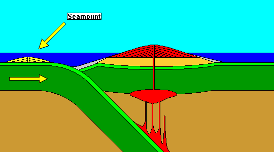
Sometimes there are things on the descending plate, like seamounts (submarine volcanoes), submarine volcanic plateaus, or small bits of continent.
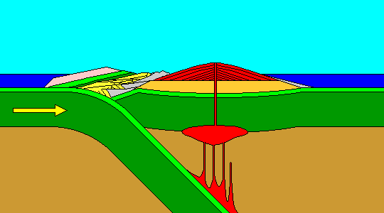
Various other things can collide with the overriding plate, too. Sometimes slabs of the descending plate break off and ride up. Submarine volcanic plateaus can add to the growing pile, called an accretionary complex. The Lesser Antilles are probably something like this.
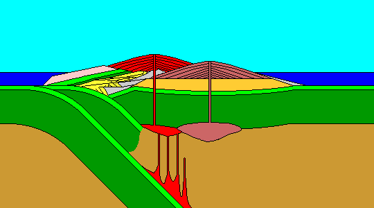
Eventually the subduction zone can get so clogged that the descending plate breaks and forms a new subduction zone. Repeat this process long enough and a sizable land mass can accumulate. Costa Rica and Panama are examples, as are much of Indonesia. If this happens on the edge of a continent, the continent can grow. Most of the U.S. from Nevada on west, and much of the Canadian Rockies, formed this way. The generic term for these bits of added-on material is "terrane." Yes, that's the spelling. A perfect example of this process today is Australia slowly bulldozing eastern Indonesia.
And this is how the Greater Antilles formed. They did not exist before the continents broke apart.
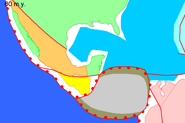
Here's a probable reconstruction of the Gulf of Mexico and Caribbean about 60 million years ago. Nort America, Yucatan and Baja California are green. Baja California has not yet separated from Mexico (orange). Nicaragua and Honduras are yellow. North America is similar enough to the present day to be recognizable. South America is pink. Subduction zones are red lines with semicircles, and the semicircles are on the overriding plate.
The Caribbean (gray) is actually thick oceanic crust, probably a large submarine volcanic plateau, and was originally part of the Pacific. As Norrth and South America pulled apart, the Caribbean was shoved in between them. It has subduction zones almost all the way around, and accretionary complexes (brown) are buiilding up. On the south, these will become Costa Rica and Panama, and on the north they will become the Greater and Lesser Antilles.
You'd think that with all the oil and gas exploration in the Gulf of Mexico, we'd know this history in minute detail. We don't for a lot of reasons. First, as plates moved around, a lot of crust was subducted and the evidence lost. Second, the magnetic patterns that are so useful for tracking the motions of continents don't exist in the Gulf of Mexico, because there was a long interval where they didn't form, for still unknown reasons. And the Caribbean, which probably formed in the Pacific as a volcanic plateau, doesn't have them.
Return to Professor Dutch's Home Page
Created 13 February 2021, Last Update