Crustal Deformation
Steven Dutch University of Wisconsin - Green Bay
Economic Consequences of Geologic Structures
- Tracing Coal Seams, Aquifers, etc.
- Ore Deposits are often localized along faults and folds
- Petroleum Traps
Types of Folds
Small Structures
- Anticline
- Syncline
- Monocline
- Homocline
Large Structures
- Dome
- Basin
- Arch, Swell, Upwarp
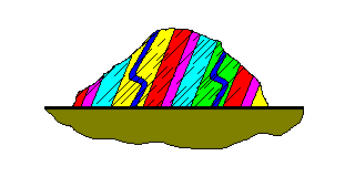
Foliation
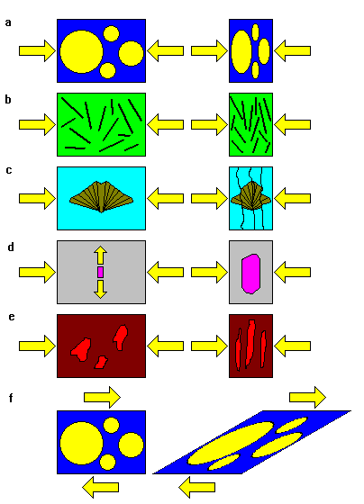
Foliation is a sheetlike structure that forms when rocks are deformed. As the figures show, it forms in a variety of ways, but in every case, the foliation is at right angles to the direction of greatest compression.
| a. Foliation can simply form when objects in the rocks are flattened. b. Foliation can form when flattening causes platy mineral grains to align, much the way toothpicks would be aligned when swept up by a broom. c. Solutions often remove large amounts of material from rocks as they are being deformed. The solutions move in the direction of least resistance. d. Elongate crystals grow in the direction of least resistance. e. Pockets of molten material may form during high-temperature metamorphism, and these may be flattened. This is one possible way banding in gneiss forms. f. Shear, like along a fault, also produces foliation. As the shear deformation becomes greater, the foliation becomes stronger and more closely aligned with the fault plane. |
 |
Banding in Gneiss
| a. Often the banding in gneiss is a relic of original bedding, especially if the original rocks had alternating beds of dissimilar composition. b. As ferromagnesian minerals form, they accumulate iron and magnesium from their surroundings, which become depleted. The result is a mass of ferromagnesian minerals surrounded by quartz and feldspar. c. As rocks begin to melt, the granitic components melt first, following Bowen's Reaction Series in reverse. As the melt collects, the remaining rock becomes enriched in ferromagnesian minerals. This is another way to create alternating bands of light and dark minerals. d. As folding progresses, the sides (or limbs) of folds become progressively more thinned out. Alternating bands of segregated and finely-intermingled minerals result. |
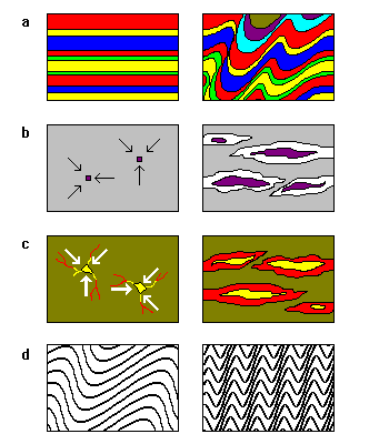 |
In reality, all of these mechanisms may be at work simultaneously in gneiss formation.
Folds and Foliation
On a small scale (microscopic to centimeters), foliation forms by a variety of mechanisms, but always at right angles to the direction of greatest compression
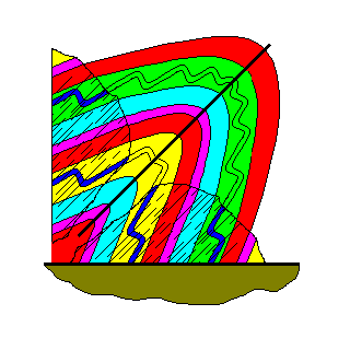
On a large scale (centimeters to kilometers), rocks fold. The axial plane of the fold is also at right angles to the direction of greatest compression
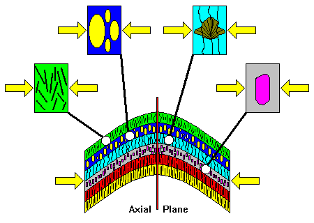
Therefore, foliation in deformed rocks is generally parallel to the axial plane of the fold. This relationship makes it easy for a geologist working in deformed rocks to tell something about the orientations of large folds.
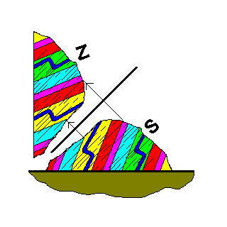
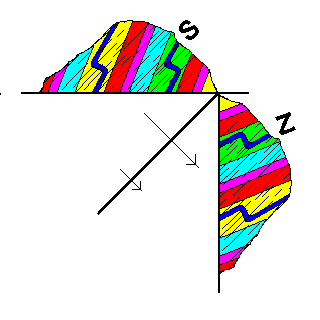
The Importance of Minor Folds
| When rocks fold, the layers slip over each other, and thin beds are sometimes crinkled into so-called minor folds. Note that the folds are Z-shaped on one side of the fold and S-shaped on the other. A geologist can tell that she's crossed the axial plane of a fold by observing that the minor folds change from S- to Z-shaped (or vice versa). | 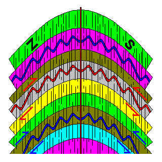 |
How Geologists Use These Clues
 |
Here's an outcrop that might be seen in the field. The beds are dipping steeply to the left, hinting perhaps that the beds are on the flanks of an anticline somewhere off to the right. However, the foliation also dips to the left, and the minor folds are inconsistent with an anticline off to the right. |
 |
Mentally, we picture the axial plane of the fold as parallel to the foliation. The other side of the fold is roughly a mirror image of the side we can see. We can guess it's a tight anticline with its right side overturned. There must be a syncline to the right of the outcrop.
Note that we have no idea how big the fold is. The axial plane could be a meter or a kilometer away. What we are interested in is figuring out what kind of fold it is and how it is oriented. |
 |
We can mentally fill out the sketch to get an idea of the shape of the fold. Note that we still have no idea how big the fold is, but we know it's an anticline and have some idea of its shape and orientation. Note that we can conclude the beds in the outcrop are overturned. If we just naively concluded there was an anticline to the right and a syncline to the left we'd be exactly wrong. |
 |
How do we know the axial plane is on this side of the outcrop? It doesn't matter. Here we place the axial plane to the right and construct the mirror image. |
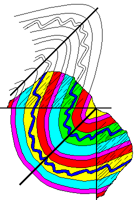 |
If we put the axial plane on the other side of the outcrop we would conclude the fold to the right was a syncline, and there is an anticline to the left. We end up with the same results either way. |
Oh, by the way, why can't we have the axial plane running through the outcrop itself? Answer below.
Diapirs
Salt domes are the best known and most common diapirs. In the cross-section above, light blue represents salt and other shades represent other sedimentary rock layers. Salt is both very ductile and much less dense than most other rocks. If it finds a weak spot in the overlying rocks (left) it begins to flow upward. The pressure of adjacent rocks on the salt layer, plus the low density of the salt, cause the salt to continue rising (center). In advanced stages, the salt often takes on a mushroom shape (right) and can even become entirely disconnected from its roots. The upturning of layers adjacent to the salt creates numerous traps for petroleum. In the North Sea and Gulf of Mexico, the search for petroleum basically amounts to a search for salt domes.
The salt can and often does reach the surface. On the Gulf Coast, the salt is very vulnerable to solution, and collapse due to solution is common. In extremely arid regions, notably Iran and Morocco, salt that reaches the surface can flow downhill as a salt glacier.
Intrusions like granite also commonly rise as diapirs. Some even have a teardrop outline.
Isostasy
Isostatic Rebound Since the Pleistocene
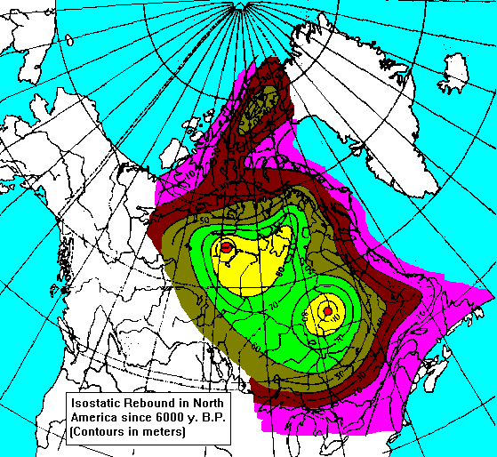
Isostatic Rebound in Canada
Isostatic Rebound in Scandinavia
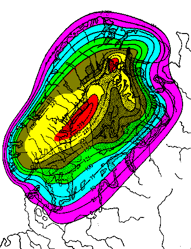
It's probably no accident that two of the largest epicontinental seas (seas extending deep into the continent) on Earth are Hudson Bay and the Baltic, both dead center in areas of active isostatic uplift. In all likelihood, the crust in these regions is still depressed and has not finished rising, and when uplift is complete both seas will mostly or entirely disappear. Gravity measurements suggest that the crust in the Hudson Bay region has another 100 meters still to rise.
Epeirogeny
Epeirogeny is gentle uplift or subsidence of the crust, sometimes by kilometers, but with little igneous activity, faulting, metamorphism, or intense deformation. The mechanisms of epeirogeny are not well understood. Epeirogenic regions are characterized by domes, arches, and basins. The Great Lakes region is one of the best illustrations of epeirogeny anywhere.
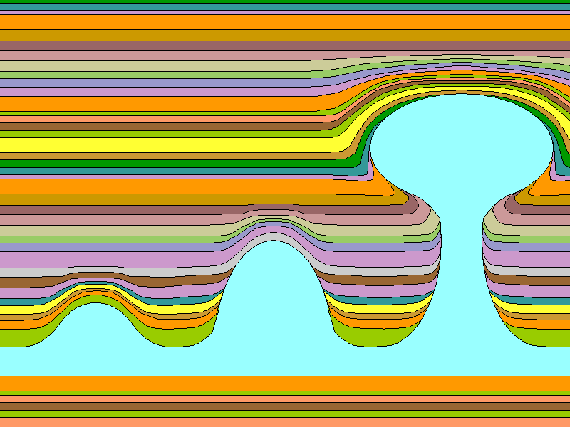
Basins and Uplifts in the Midwest
| Legend Cretaceous (Gray) Jurassic (Blue-Gray, Michigan) Permian (Dark Blue) Pennsylvanian (Violet) Mississippian (Blue) Devonian (Light Blue) Silurian (Light Green) Ordovician (Brown) Cambrian (Yellow) Precambrian (Red) Units within the Great Lakes are horizontally ruled. |
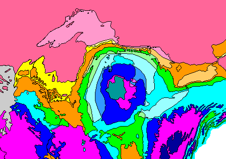 |
The map above shows the geology of the Great Lakes region. Note that the pattern around Michigan is like a bulls-eye, with younger rocks in the center. Thus, we find Silurian rocks in eastern Wisconsin and Ontario, but they are buried beneath younger rocks in Michigan and are below the surface. Thus the rocks sag downward under Michigan. The structure is like a syncline, but much more broad and gentle, and it's more or less equidimensional. We call such a structure a basin. In Wisconsin, we find old rocks in the center becoming younger as we move away. We'd have to drill downward to find Precambrian rocks in LaCrosse or Green Bay, but they are on the surface in Wausau. Hence the rocks in Wisconsin arch upward, like an anticline but again much more broad and gentle. If this structure were closed on all sides we would call it a dome, but since it's open at each end we refer to it as an arch
Note also how the Great Lakes correlate with the rock units. Lake Michigan, the main portion of Lake Huron, and Lake Erie are mostly underlain by Devonian rocks, mostly shales, which were easily excavated by the glaciers. The Green Bay lowland and Green Bay itself were scoured out of soft Ordovician shales (the Maquoketa Formation). So were the channels between the islands in Lake Huron and the mainland, Georgian Bay, the lowland across southern Ontario, and Lake Ontario. Four of the Great Lakes have their shapes and locations determined by structures in the Paleozoic rocks (and Lake Superior is excavated out of relatively soft Precambrian sedimentary rocks as well).
The outer edge of the Silurian rocks forms the Niagara Escarpment, which wraps around the north side of the Michigan Basin. It runs along Lake Winnebago and Green Bay, into Michigan, across the Lake Huron islands, down the Bruce Peninsula, across Ontario, and into New York. The Bruce Peninsula, the peninsula in Ontario that separates Lake Huron from Georgian Bay, is a geological and ecological twin of the Door Peninsula, but less developed.
| Legend Cretaceous (Gray) Jurassic (Blue-Gray, Michigan) Permian (Dark Blue) Pennsylvanian (Violet) Mississippian (Blue) Devonian (Light Blue) Silurian (Light Green) Ordovician (Brown) Cambrian (Yellow) Precambrian (Red) Units within the Great Lakes are horizontally ruled. |
|
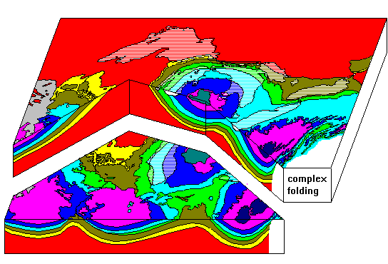
The diagram above gives a three-dimensional view of the structure of the rocks. The vertical scale is very much exaggerated. Precambrian rocks are exposed in Michigan and Ontario, and are 5 km beneath the surface in the center of the Michigan Basin. We know that because a consortium of oil companies and universities drilled a well there in the 1970's. Thus the Michigan Basin is 500 km across but only 5 km deep. At the scale of this drawing, the true depth of the Michigan Basin would be about one screen pixel deep. No attempt has been made to show the complex folding in the Appalachians.
Note that all units are not present everywhere. Cambrian rocks are absent north and east of the Michigan Basin, and Silurian rocks are absent in the southwestern part of the map area. Layers do not extend forever; they may be absent because they were eroded away or because they were never deposited in certain areas.
Basins are not just empty holes filled by sediments. Everywhere the rocks in this region show evidence of being deposited in shallow water (100 meters deep at most). The sediments accumulate because the crust is subsiding. Note how in Michigan sediments accumulated from the Cambrian through the Pennsylvanian, then stopped. Later on, in the Jurassic, there was a little more subsidence, allowing a little more deposition to take place. It's fairly common for sedimentary basins to resume activity after long periods of inactivity, and it seems to correlate with major periods of mountain-building, but the exact process is still not well understood.
| This diagram shows the principal basins and arches of the upper Midwest | 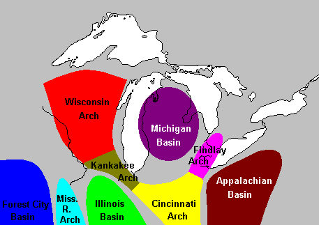 |
Orogeny
Types of Mountains
- Volcanic
- Erosional
- Fault Block
- Fold
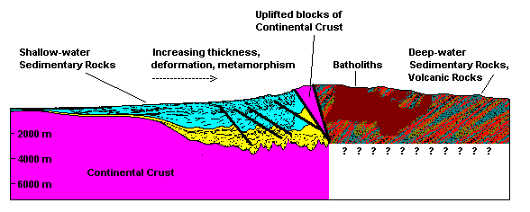
A cross-section through a typical mountain range looks something like this. As we proceed from the stable interior of the continent into the mountain range, we encounter a belt of shallow-water marine sedimentary rocks. These rocks become thicker and more intensely deformed the farther we go into the mountain range. There are frequently uplifted blocks of deep continental crust, then a belt of quite different rocks. In the most intensely-deformed and metamorphosed part of the mountain range, the rocks consist of thick, deep-water marine sedimentary rocks with abundant volcanic rocks. These rocks are often intruded by batholiths.
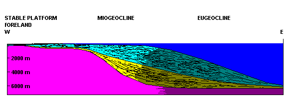
Mountain belts are thought to begin as ordinary continental shelves and slopes as shown above. The continental shelf rocks are sometimes termed the miogeocline and the deep-water continental slope rocks are often termed the eugeocline.

Deformation, metamorphism and igneous activity may begin when plate subduction begins along the continental margin.
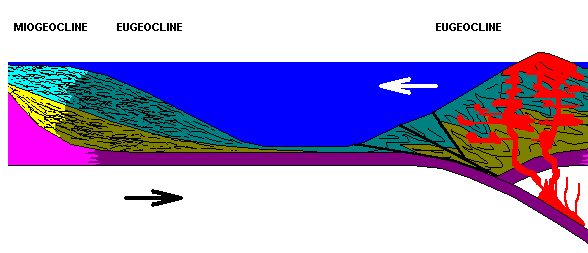
Sometimes plate movements may cause the leading edge of a continent to collide with another fragment of crust, often a volcanic island arc. This is another way to juxtapose shallow-water rocks with deep-water and volcanic rocks.
Answer
If we had the axial plane running through the outcrop, we would actually see the curve of the fold. Since we don't, the axial plane has to be off to one side somewhere.
Return to 296-202 Visuals Index
Return to Professor Dutch's Home Page
Created 22 May 1997; Last Update 12 November 1998