Pleistocene Glaciers and Geography
Steven Dutch, Professor Emeritus, Natural and Applied Sciences, University of Wisconsin - Green Bay
Northern Hemisphere Ice Sheets
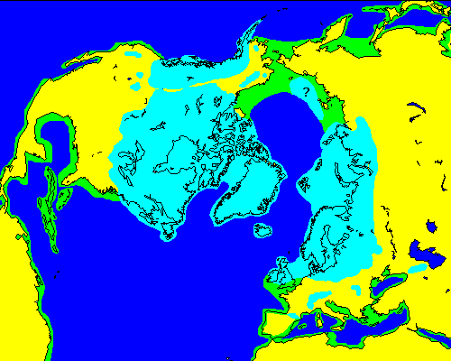
Ice caps in North America and Europe are well documented. The ice removed water from the sea, lowering sea level by up to 100 meters. Large areas of the continental shelves were exposed. Most of the ice north of Siberia accumulated on what is now the shelf and the extent of Siberian ice is poorly known. Lowering of sea level also exposed the Bering Strait land bridge.
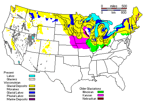
Glacial Deposits and Landforms in the Continental United States
Retreat of the Pleistocene Ice Sheets
Retreat of the Ice from North America
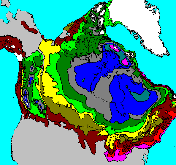
| Color | Age |
| White | Present |
| Magenta (north) | 5000-6000 |
| Blue-Gray | 6000-7000 |
| Blue | 7000-8000 |
| Dark Gray | 8000-9000 |
| Dark Green | 9000-10,000 |
| Light Green | 10,000-11,000 |
| Yellow | 11,000-12,000 |
| Light Brown | 12,000-13,000 |
| Dark Brown | 13,000-15,000 |
| Red | 15,000-17,000 |
| Magenta (south) | 17,000-18,000 |
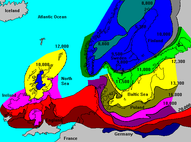
Ice Retreat From Europe
Ice Diversion of Rivers in North America
Ice Diversion of the Missouri River
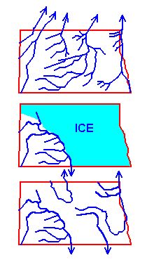 |
Top: The Missouri River did not exist in its present form before the Pleistocene. At that time, the largest drainage in North America flowed northeast to Hudson's Bay. This map shows the buried pre-Pleistocene valleys in North Dakota, identified by well drilling.
Middle: During the Pleistocene, about 2/3 of North Dakota was ice-covered. Water flowed along the ice margins to the south. This is called an ice-marginal drainage. Bottom: The ice-marginal drainage remains as the present Missouri River. Many of the other present rivers of North Dakota are also ice-marginal drainages. Only a few of the pre-Pleistocene valleys were re-occupied after the ice retreated - the rest were filled in and are known only from well drilling. |
Formation of the Ohio River
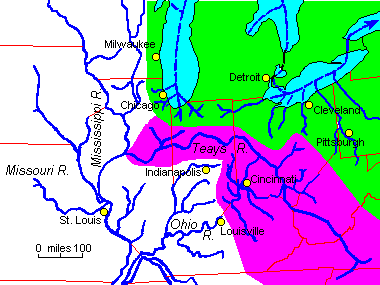 |
The Ohio River did not exist as such before the last ice advances. A great buried river valley, called the Teays River, probably was the principal east-west drainage in the Midwest before then. The present Ohio formed when ice blocked the Teays valley and river headwaters flooded and linked across drainage divides.
The Teays drainage basin is shown in purple. The Saint Lawrence drainage basin is shown in green. |
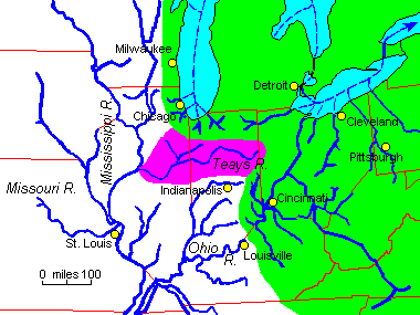 |
It's reasonable to suppose that the Teays drainage itself was the result of earlier ice diversions. Here is one possible pre-Pleistocene drainage configuration.
The large river flowing northwest across Virginia and West Virginia is the ironically-named New River. Its upper portion was never diverted by ice and the river flows in a deep gorge. It is one of the oldest identifiable rivers in North America. |
Ice Diversion of the Hudson River
In the maps below, HR denotes the Hudson River, M is Manhattan, LI is Long Island and SI is Staten Island
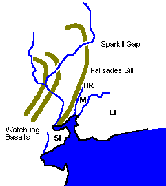 |
Before the Pleistocene, rivers in the eastern U.S. flowed across an ancient erosion surface. As the land was uplifted the rivers cut deep gorges through resistant ridges. The probable early course of the Hudson River is probably marked by a number of deep notches in ridges near New York City. |
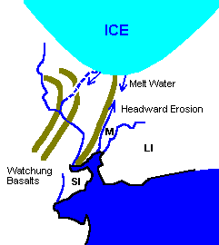 |
As the ice was retreating, flow down the ancestral Hudson would have been cut off. Meanwhile, large amounts of melt water would have poured along the Palisades Sill, cutting into the soft rocks beneath. Most of the area shown as sea would have been dry land at this time. |
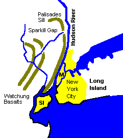 |
After the ice retreated, the Hudson river was diverted into its present course along the Palisades Sill. |
Pluvial Lakes
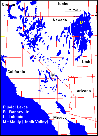 |
During the Pleistocene, a wetter climate in the West caused large lakes to fill some of the interior basins. The most important ones are:
|
Evolution of the Great Lakes
The English Channel
|
Before the Pleistocene, the British Isles were probably connected to the mainland. Submerged valleys hint at a former continuation of the Rhine out onto the North Sea shelf, with the Thames and probably the Elbe as tributaries. |
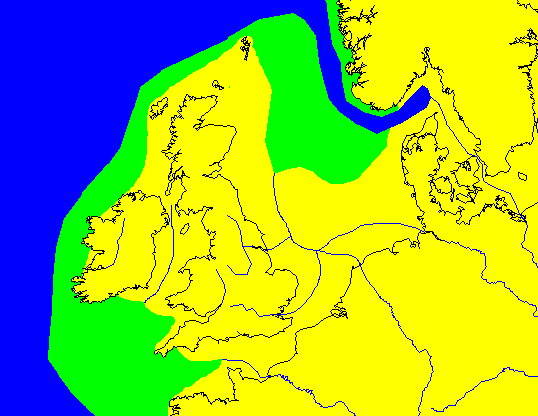 |
| At ice maximum, only the far south of the British Isles was ice-free. The Rhine, blocked to the north, flooded its valley and found a new outlet. | 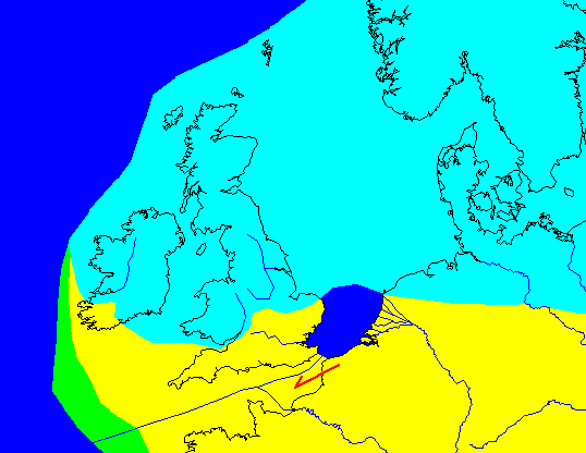 |
| Following the retreat of the ice, the sea floods the new valley, creating the English Channel. Think of all the history that flows from Britain being an island - the defeat of the Spanish Armada, the opposition to Napoleon and Hitler - and none of it might have happened if the ice hadn't blocked the North Sea. |  |
Siberian Super-Rivers?
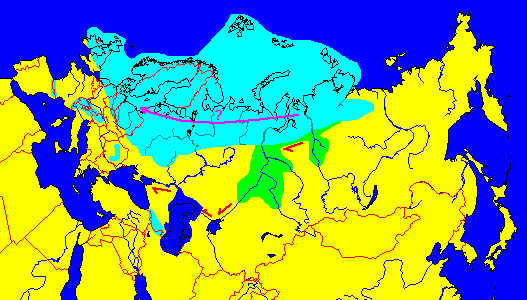
If the ice north of Siberia blocked the major rivers Ob and Yenisey, they would have ponded until they found new outlets. Lake Baikal might have drained to the Mediterranean through the longest river in the world - some 6,000 miles. Later, as the ice retreated, water would have drained along the ice margin to the Baltic as shown in purple.
Some geologists, however, believe the Siberian ice cap was much smaller and may not have connected to the Scandinavian ice cap.
Coming to America
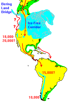 |
The most likely route for humans to enter America was overland via the Bering land bridge. Some anthropologists believe humans could not have gotten further south until the clearing of the Ice-Free Corridor about 12,000 years ago. However, the Corridor was never extensively blocked by ice, and short ice blockages might not have been a serious obstacle.
Other anthropologists have suggested that immigrants could have traveled via the coast, hopping from one ice-free enclave to the next. Recently, even a trans-Atlantic route has been proposed, perhaps following the margins of pack ice in pursuit of seals. However, given the distances involved, that seems like a long shot. What about much earlier arrivals? It takes time for any species to expand its range, and there's just no evidence that humans got to Siberia or the Americas before at most 25,000 years ago. |
Given the time scale above (which some anthropologists reject as too old), humans could have reached Tierra del Fuego at a rate of only a kilometer or so a year. Even if humans didn't get into the U.S. until 12,000 years ago, they could have reached the tip of South America migrating only 5-6 kilometers a year.
Who killed the mammoths? The jury is still out. Megafaunas everywhere went extinct about the time humans arrived, but why hunt mammoths when buffalo, or even rabbits, are more abundant? The last mammoths, by the way, lived on Wrangel Island off Siberia and actually survived until about the time the Pyramids were being built.
Return to 296-202 Visuals Index
Access Slides of Glaciers
Return to Professor Dutch's Home Page
Created 20 January 1997; Last Update November 22, 1999
Not an official UW-Green Bay site