Mass-Wasting
Steven Dutch, Professor Emeritus, Natural and Applied Sciences, University of Wisconsin - Green Bay
Types of Mass-Wasting
Movement of Large Amounts of Material Downhill under Gravity
- Creep
- Mudflows
- Slump
- Rockfalls
- Avalanches
Viaont, Italy, October 9, 1963
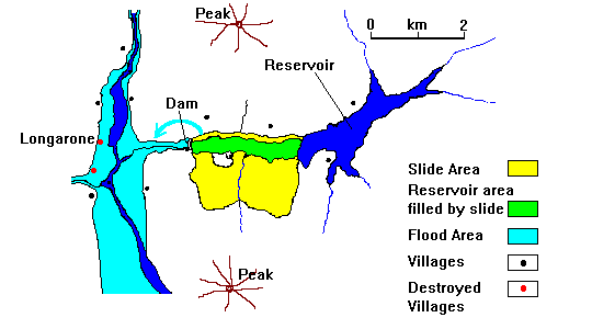 |
| The nearly 300-meter tall Vaiont Dam was the tallest in Europe when it was completed. In the fall of 1963 heavy rains weakened a shale layer south of the reservoir. On October 9 the shale gave way and the overlying layers slid downhill into the reservoir. The dam, amazingly, was undamaged. Instead, water from the reservoir was simply pushed up the opposite valley wall and around the dam. The first casualties were some dam workers staying in a hotel 300 meters above the dam. The water then poured down-valley, wiping out the village of Longarone and several smaller villages. 1800 people died. |
Yungay, Peru, May 31, 1970
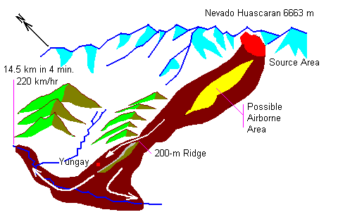 |
A magnitude 8 earthquake triggered a huge avalanche from the summit of Nevado Huascaran, the highest peak in Peru. Part of the landslide jumped a 200-meter ridge, wiping out the town of Yungay and killing all but about 100 of its 20,000 inhabitants. This is the worst avalanche disaster in history.
In addition, the earthquake killed another 50,000 people elsewhere in Peru. The total death toll of about 70,000 makes this the worst natural disaster ever in the Southern Hemisphere. |
Sherman Glacier, Alaska, March 27, 1964
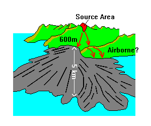 |
The great Good Friday earthquake of 1964 triggered a large rock avalanche that fell 600 meters (2000 feet) and then spread 5 km (3 miles) across the Sherman Glacier, resulting in a blanket 3-6 meters (10-20 feet) thick. The avalanche is dramatically visible because it contrasts with the white glacial ice. The drawing at left is based on a photograph. The flow ridges and lobes are characteristic of large avalanches. |
Lituya Bay, Alaska, July 9, 1958
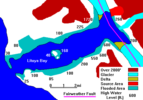 |
A magnitude 7 earthquake on the Fairweather Fault (Southeast Alaska's equivalent of the San Andreas) triggered a landlside that dropped into a glacial bay (fiord). The resulting wave washed away the forest on the opposing side to a height of 1720 feet, the highest known wave ever documented.
Note from the sketch map that this is extremely rugged terrain. Elevations rise from sea level to over 2000 feet in half a mile, a slope of nearly 45 degrees in places. |
The map is simplified from figures in Miller (1960). See References, below.
References
Don J. Miller, 1960; Giant Waves in Lituya Bay, Alaska, U.S. Geological Survey Professional Paper 354-C, 86 p. Good luck finding this. It tends to disappear from libraries. I bought what may have been the last available copy.
Return to Overheads Index
Return to Professor Dutch's home page
Created September 23, 1999, Last Update September 23, 1999
Not an Official UW-Green Bay Site