Physical Geology Slides-Glaciers
Steven Dutch, Professor Emeritus, Natural and Applied Sciences, University of Wisconsin - Green Bay
First - time Visitors: Please visit Site Map and Disclaimer. Use "Back" to return here.
Active Glaciers
 |
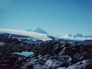
A small glacial lobe creeps down a mountainside on Gibbs Island, Antarctica. The summit is only 500 meters above sea level and the glacier is only a couple of hundred meters long. The sea is visible in extreme lower right. |
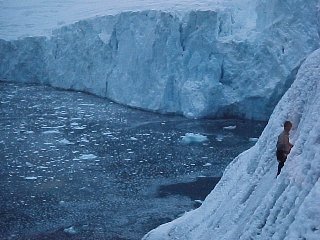 |
An ice front on a continental glacier. The front in the background is actively flowing into the sea, calving off chunks of ice occasionally. The ice front in foreground with the climber is a stagnant, ablating ice front. |
 |
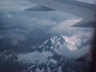
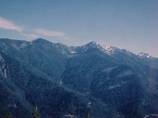
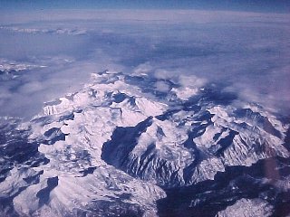
A typical continental glacier. Note the dome-like profile and the half-hidden cirque in the right distance. Mountain glaciers commonly merge into and are submerged by continental glaciers. |
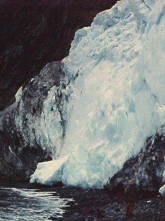 |
This active ice front flows to the sea. Note the trapped sand and rock in the glacier. This is the material that shapes glacial landscapes. |
 |
A small glacier on Gibbs Island, Antarctica. Note the crevasses created by brittle fracture. Note that they appear to be covered with snow. In reality the snow is only a cover, which may or may not support a climber's weight. Note also the ridge of loose material along the edge of the glacier. Rubble falling onto the glacier is dragged along, creating a lateral moraine. |
Cirques
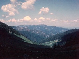 |
Standing in Oregon, looking into California from a small cirque. The curvature of the valley and the deposits in the foreground indicate a former glacial valley, but the valley downslope is a typical V-shaped fluvial valley. The glacier extended about to the shadow line. |
 |
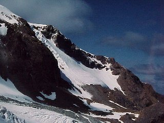
An active cirque on the Antarctic Peninsula. The ridge is only about 500 meters above sea level and a couple of kilometers from the sea. The splintery landscape above the glacier is due to snow avalanches and intense frost action and is calle a nivation landscape (from the Latin word for snow). |
 |
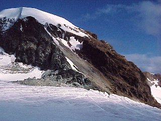
The head of a glacier on Mount Shasta, California. The glacier pulls away from the headwall of the cirque, plucking rocks away and creating the distinctive shape of the cirque. The glacier also creates a crevasse called a bergschrund adjacent to the headwall. |
 |
A bergschrund at the head of a glacier on Mount Shasta, California. |
 |
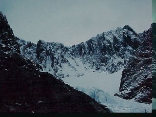
A large cirque in the Patagonian Andes on the Argentina-Chile border. A glacier still fills the cirque. The ridge around the cirque is composed of spiky peaks called horns and knife-edged ridges called aretes. |
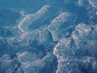 |
Aerial view of cirques and glacial valleys in the Colorado Rockies. |
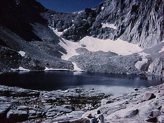 |
A cirque at the base of Mount Whitney, California. Small lakes like this are common in cirques. The cliff behind rises almost 3,000 feet to the summit of Mount Whitney. |
 |
A small cirque in the Klamath Mountains of Oregon, barely 4,000 feet in elevation. Glaciers could form this low because of the extremely heavy winter snowfall. Note the lobe in the valley, probably due to solifluction, or flow of saturated soil over permafrost. It hasn't moved in some time because there is a large tree growing on it. |
 |
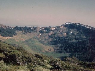
Marble Mountains, northern California. The summits are at 8,000 feet, the photo locale is at 5,000 feet, and the valley floor is at 2,000 feet. Cirques formed near the summits but the glaciers did not extend far down valley. |
Moraines
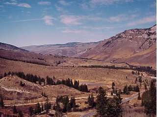 |
A valley glacier flowed down from the left to make this moraine near Leadville, Colorado. Several stages of retreat can be seen. At its height, the glacier merged with another one flowing down the valley in the background. |
 |
Glacial margins don't get any clearer than this one near Chelan, Washington. The area left of the line of large boulders was not glaciated. |
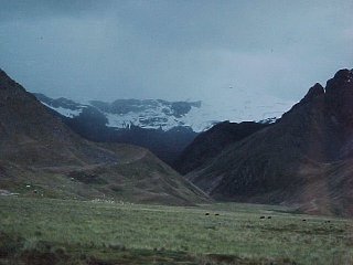 |
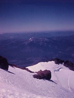
Moraines are where you find them, even in Peru. The latitude is 15 degrees south of the equator. The valley floor is at 13,000 feet. The glacier is at 17,000 feet and the summits hidden in the clouds exceed 20,000 feet. |
Drumlins
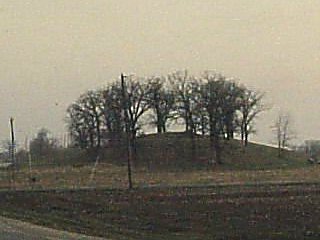 |
A small drumlin south of Rosendale, Wisconsin. |
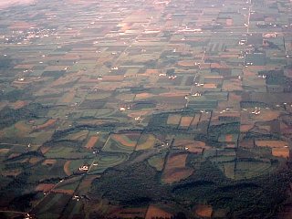 |
Drumlins southeast of Fond du Lac, Wisconsin. |
Glacial Valleys
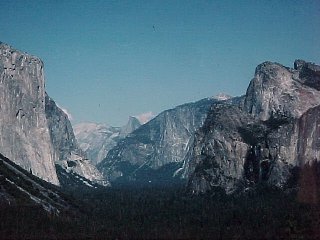 |
The premier glacial valley in the U.S. is Yosemite, in California. The valley floor is flat because of deposits laid down in a lake after the glaciers melted. |
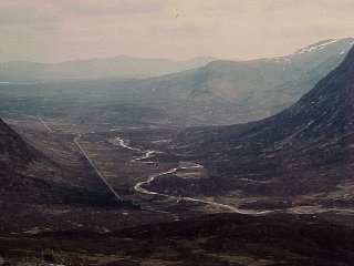 |
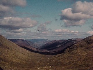
A glacial valley in Scotland, the pass of Glen Coe. Ice filled the basin in the background and flowed outward down valleys in all directions. |
 |
Another glacial valley in Scotland. Note the large rock in the valley, a whaleback or roche moutonee. In the left distance is Ben Nevis, highest peak (only about 4500 feet) in the British Isles. Note that all the summits define a flat plain, a possible relic of an ancient land surface. |
 |
A spectacular glacial landscape in the southern Sierra Nevada, California. The uplands are covered with cirques and glacial troughs but the valleys show only evidence of fluvial erosion. |
 |
What the scene above might have looked like during the Pleistocene. |
 |
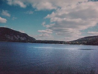
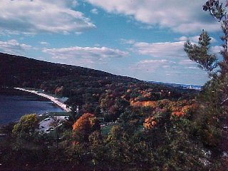
The Finger Lakes of central New York are flooded valleys scoured by the glaciers and dammed by moraines. |
Small-Scale Glacial Features
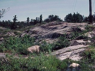 |
This sculpted outcrop in Ontario is typical of glacial sculpting and abrasion. Increasingly, high-pressure melt water beneath glaciers is being shown to play a role in subglacial erosion as well. |
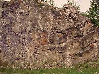 |
This exposure shows layered water-laid deposits and till, a coarse mixture of everything from silt to boulders. It has all the features we might expect from any cut in glacial deposits anywhere, but it's 2.3 billion years old. This is the Gowganda Formation of Ontario, one of the earliest preserved glacial deposits on Earth. |
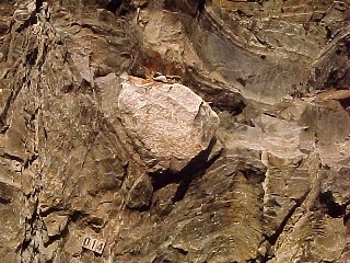 |
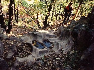
A close-up of the previous picture. The boulder is sitting in fine-grained layered sediment, with deformed layers underneath. This is a dropstone. It was probably frozen into a block of ice, drifted over a glacial pond or lake, then plummeted to the bottom. |
 |
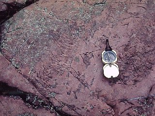
The gouges in the otherwise glacially polished surface are called crescentic gouges. They appear to form when large rocks are pushed down with great force into the underlying surface, creating a conical fracture. Melt water gets under the lip of the fracture, freezes and expands, and part of the fracture is exposed.
The bow of the crescent points in the direction of ice movement (here, right to left). |
 |
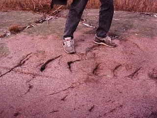
These rows of small crescent-shaped cracks are often called chatter marks. In contrast to crescentic gouges, the horns of the crescents point in the direction of ice movement (here, bottom to top). Note the striations as well.
How do we know the relation between ice movement and the fractures? Many glaciers world-wide are retreating. We need only examine rocks that were deep under glacial ice in recorded history. |
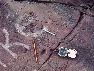 |
Sometimes you can find evidence of multiple directions of ice movement. The pencil and pen lie on two sets of chatter marks both indicating ice movement from lower right to upper left. |
 |
A small whaleback or roche moutonee (French, sheep-rock, because fields full of them look like sheep grazing). Ice rides over the upstream side and smoothes off the outcrop, but pulls blocks away from the downstream side, creating a blocky, steep front. Thus the ice flow here was from right to left. |
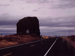 |
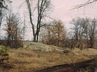
Glaciers frequently leave isolated stones (erratics) behind when they melt. This one in central Washington is especially impressive. |
Ice and Meltwater
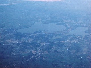 |
The city of Madison, Wisconsin lies between several glacial kettle lakes. The lakes formed when glacial ice remained behind in a former river valley and was buried by outwash deposits. |
 |
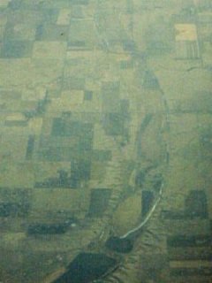
Water diverted by ice is termed ice-marginal drainage. In the foreground is the edge of a moraine in northeasternmost South Dakota. In the distance are several dark strips which mark valleys cut by streams flowing along the ice margin. The most distant one is the Missouri River, which is essentially an ice-marginal drainage along the lower half of its course. |
 |
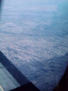
Subtle braided textures can be seen on these fields in Ohio, marking the locations of former braided glacial meltwater streams. |
 |
The Potholes Trail down the south side of the Baraboo Bluffs was clearly eroded by fast-moving sediment-laden water, but there is no stream there now.The potholes are believed to have formed when melt water from the glaciers flowed down the bluffs here. |
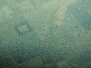 |
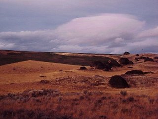
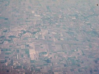
The subtle ring-shaped features occur in a never-glaciated part of South Dakota. They may be relics of pingoes, mounds that form now in the Arctic when ice trapped underground expands. |
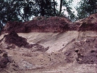 |
In Northeastern Wisconsin, the main glacial retreat was followed by a quick readvance that deposited a thin layer of distinctive red till. This pit west of Oshkosh shows red till on top of cross-bedded outwash sands. |
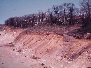 |
Outwash deposits banked up against a bedrock escarpment, de Pere, WI |
 |
This wide, smoothly curving valley in South Dakota has only a tiny stream flowing in it. A stream too small to carve its valley is said to be underfit and usually indicates that the valley once carried much more water. The smooth curves and uniform width suggest large volumes of high-speed water when the valley was carrying glacial meltwater. |
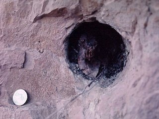 |
In northeastern Wisconsin, the main glaciat retreat was followed by growth of a forest, which was then overridden and buried by a late, short-lived glacial advance. Here is a log buried in the later deposits. This is silt deposited in a lake that backed up and drowned the forest. |
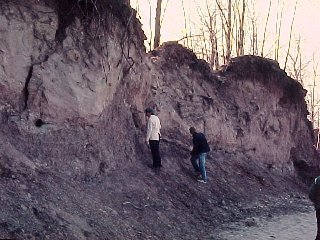 |
View of the bank, with lake silt making up most of the bank and red till on the top. The only animal fossils in the deposits are snails and beetles. You have to be pretty slow not to outrun a glacier. |
 |
Devil's Lake, Wisconsin. Glaciers never got into the valley but outflanked it on either end, building moraine dams. |
 |
The northern moraine dam of Devils Lake. |
Access Course notes on Glaciers
Return to Physical Geology Notes Index
Return to Professor Dutch's Home Page
Created 13 July 1998, Last Update 12 January 2001