Physical Geology Slides-Sedimentary Rocks
Steven Dutch, Professor Emeritus, Natural and Applied Sciences, University of Wisconsin - Green Bay
Landforms of Sedimentary Rocks
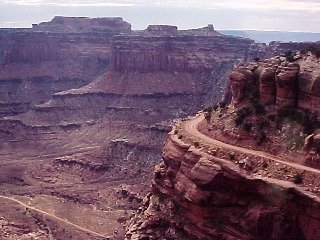 |
A mesa (Spanish for table) is a flat-topped hill capped with resistant rocks (they can be volcanic).
These mesas are in Canyonlands National Park, Utah
|
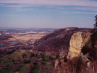 |
Grandfather Bluff, near LaCrosse. Flat-topped hill ... capped with resistant rocks ... what part of the definition of "mesa" doesn't apply here?
Well, none. If these were in Wyoming, we would call them mesas without hesitating. We don't use the term because we think of mesas as "western" and Wisconsin as "eastern." But early writers on Wisconsin geology called hills like this mesas without batting an eye.
|
|
|
 |
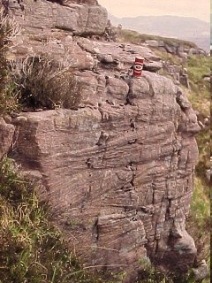
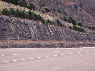
A ridge formed by steep resistant rocks is a hogback. This hogback is in Wyoming. |
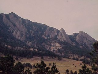 |
When a mountain front is faced by steep hogbacks, they are often called flatirons because, well, they look like flatirons. These, the classic examples, are near Boulder, Colorado. |
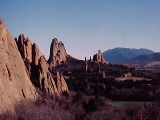 |
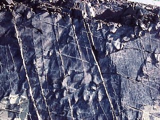
Vertical beds can sometimes form steep crags, like these at Garden of the Gods, Colorado Springs, Colorado. |
Stream Abrasion
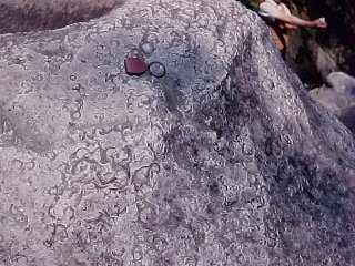 |
Percussion marks on a quartzite boulder in Vermont. This boulder is at the bottom of a very narrow gorge and probably takes a pounding by other rocks during floods. |
Graded Bedding and Wave Action
 |
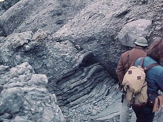
Graded bedding in volcanic sediments, Lemaire Channel, Antarctica |
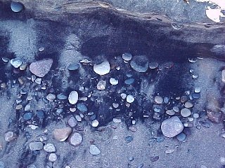 |
This looks like horrible pollution but is actually perfectly natural. On the Lake Michigan shoreline, wave action washes away light minerals, leaving only black magnetite sand at the high-water mark. |
 |
When wave conditions are right, layers of almost pure magnetite can form, like those seen in this shallow trench. |
Cross-Beds and Channel Fill
 |
Large cross beds, Ontario |
 |
Small festoon cross beds, Scotland. |
 |
Three sets of delta cross beds, southern Illinois. Sea level was rising and streams deposited three successive deltas, one atop the other. |
 |
What some cross beds look like from above. The currents scoured small channels that filled in from left to right. |
 |
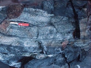
Two large dhannel fills, eastern Kentucky. |
Ripple Marks
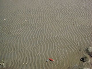 |
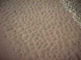
Ripple marks on the muddy bottom of Green Bay, formed during a low stand of the Bay. |
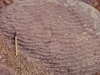 |
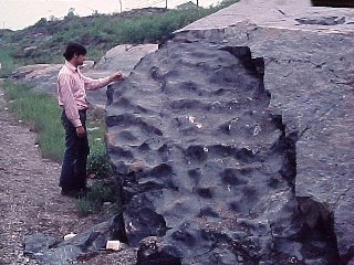
Virtually identical ripple marks from the Baraboo Quartzite, 1600 million years old. |
 |
When waves come from two directions at once, interference ripple marks like these in Ontario form. |
 |
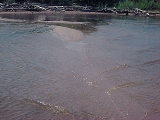
Modern interference ripple marks on the bottom of Green Bay. |
 |
One way interference ripple marks can form. |
Mud Cracks
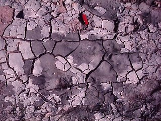 |
Mud cracks on the bottom of a modern puddle. |
 |
Mud cracks in the dolomite at Maribel Caves, evidence that the limy mud that formed these rocks occasionally dried out. The rocks probably formed in a tidal flat environment. |
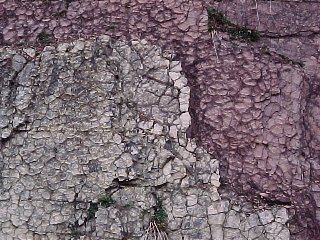 |
Mud cracks in Cambrian rocks in southwestern Virginia. Even the curls of the flaking mud are preserved. We are looking at the top of the beds here. |
A Riddle
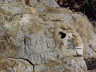 |
The inscriptions are not hard to figure out, but what carved the perfectly circular hole?
Would it help to note that Fort mccoy Military Reservation is just out of the picture to the right?
|
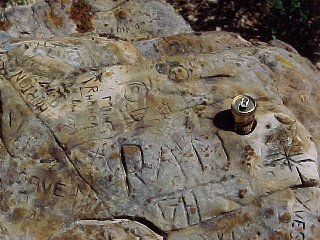 |
A little search turned up the artifact that made the hole. Humans affect the geologic record, and geologists often have to decide if a feature is of natural or human origin. |
Loading Features
 |
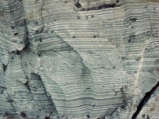
When sediment is deposited faster than it can compact, it can sag downward into still-mushy layers below, and mud can squirt upward. Sags like these are called load casts. These are from the Antarctic Peninsula. Note that the coarse bed is graded and the largest grains fill the bottoms of the sags. |
 |
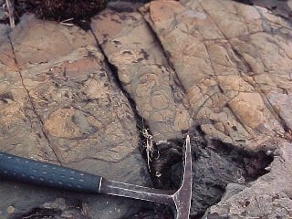
Sometimes mushy sediment will find only a few weak spots, and produce isolated structures like this, called a flame structure. This one is near Sudbury, Ontario. |
 |
This looks like a dike, but close inspection shows that the rock is sandstone. A clastic dike? Yes, that's exactly what it's called. This one is north of Lake Huron in Ontario. Clastic dikes form when sediment is partially consolidated but under high pressure. If a water-laden layer can find a weak spot in the overlying layers, it squirts upward. Earthquakes are a common trigger. Note how large pieces concentrated in the center where flow was fastest. |
Soft-Sediment Deformation
 |
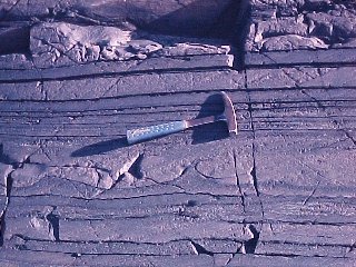
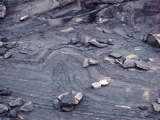
The very uniform layers here are varves, alternating thick and thin layers formed in a glacial lake. The contorted zone running across the center is probably due to glacial ice shoving the upper layers of sediment over the lower layers. Deformation that occurs while sediments are partly or wholly unconsolidated is called Soft-Sediment Deformation |
 |
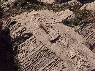
Here semi-consolidated beds broke up during a slump. Note the piece dead center rolled into a spiral. |
 |
Here a stack of layers slid over the underlying layers, rumpling into a fold. |
Submarine Landslides
 |
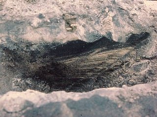
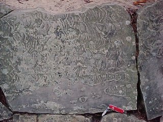
Submarine landslides are common on the edge of the continental shelf. The landslide flows scour flutes in the underlying sediment, then come to rest as graded beds of sand and silt that fill in the sculpted bottom. We are looking at the underside of a submarine landslide deposit in New Brunswick. |
 |
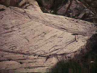
Looking at the underside of another submarine landslide deposit in New Brunswick. The flutes scoured by submarine landslides tend to be steep on the upstream end and gently-tapered on the downstream end, making it easy to tell which way they moved. These structures are hard to observe directly forming in nature but quite easy to duplicate in the laboratory. |
 |
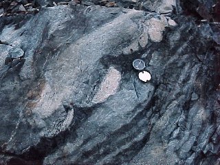
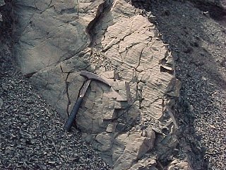
450 million years ago the continental margin of North America was bordered by reefs much like the Great Barrier Reef of Australia. Blocks of reef limestone broke off and slid down the flanks of the reef to form this submarine talus deposit, now exposed in Newfoundland. The layered rocks at the bottom are part of a single block about 100 meters in size, surrounded on all sides by small rubble. |
Return to Physical Geology Notes Index
Return to Professor Dutch's Home Page
Created 13 July 1998, Last Update 28 May 2003