Physical Geology Slides-Crustal Deformation
Steven Dutch, Professor Emeritus, Natural and Applied Sciences, University of Wisconsin - Green Bay
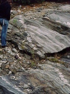
Strike and Dip
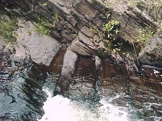 |
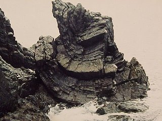
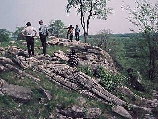
To analyze deformed rocks, we need to describe them in three dimensions. Geologists define strike as the orientation of a horizontal line in a rock layer, and dip as the angle the layer makes with the horizontal. In these sandstone beds near Copper Harbor, Michigan, the strike is the direction of the water line on the bed surfaces, and the dip is the angle the beds make with the water. |
 |
Dipping conglomerate beds near Copper Harbor, Michigan. The strike is the water line; the beds are dipping about 30 degrees to the northwest into Lake Superior. |
Unconformities
 |
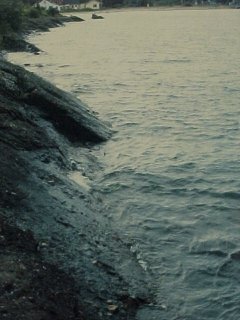
One of the great historic locations in geology. In the late 1700's, James Hutton, a founder of madern geology, became curious about the relationships between the young and nearly horizontal rocks near Edinburgh and the older, highly deformed rocks near the border between Scotland and England. He and some friends hired a fishing boat and sailed along the coast until they found this locality, now called Hutton's Unconformity. |
 |
The vertical layers are Silurian, the gently-dipping layers Carboniferous. The vertical layers were deposited, tilted, eroded away, and covered by younger layers about 100 million years later. This was one of the first places where the length and complexity of the Earth's history was fully appreciated, and Hutton's account reflects his awe at the discovery. |
Basic Features and Types of Folds
 |
Rocks that fold at low temperatures and pressures tend to fold like this - the layers bend like a stack of rubber sheets and maintain fairly constant thickness. Note that the layers in the center become contorted because they lack room to move. West coast of Scotland south of Glasgow. |
 | Some rocks are highly plastic by nature, but rocks of all kinds become plastic at high temperatures and pressures. We can define the axial plane of the folds as the surface that connects the sharpest bends in each layer. Here the axial planes are horizontal. Note that the thickness of the layers varies tremendously, but the thickness measured parallel to the axial plane is much more nearly constant. Basically the layers have no mechanical significance; the rock flows under pressure and the layers simply smear out. |
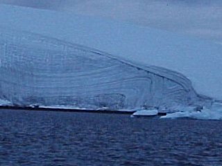 |
Ice, being ductile, also folds to produce similar folds. The axial planes of the folds in this glacier in Antarctica dip about 45 degrees to the left. Each individual folded layer is almost exactly the same shape as every other. Note also how ablation has truncated the folds, and the more recent layers on top cut across the old surface, forming a nice unconformity. |
 |
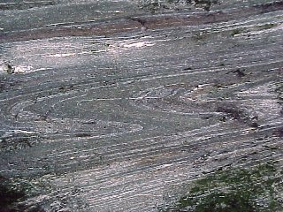
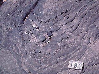
Rocks with really complex histories often look like this. Often there is no discernible pattern to the folding. |
 |
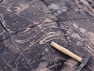
When rocks fold, individual layers within the fold often crinkle. These small folds tend to have S-shapes on one side of the axial plane and z-shapes on the other. The significance of these minor folds is that the geologist can tell which side of a large fold she is on and locate its axial plane by observing the shapes of the small folds. |
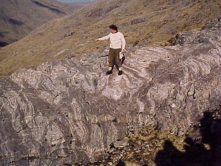 |
Using the shapes of minor folds, it's possible to work out the structure of even intensely deformed rocks. At first glance these rocks in the Scottish Highlands look hopeless, but closer inspection shows that, as intricately folded as the rocks are, they basically define a syncline. The geologist on the outcrop figured that out, and eventually zeroed in on a place where it could be seen, by mapping the shapes of small folds in the rocks.
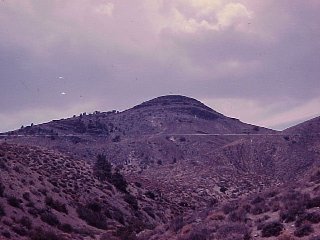
To participants (survivors), the day this photo was taken will live forever in memory as the Black Friday Death March. To get here, we climbed 3,000 feet up one mountain, 1,500 feet into a valley and 1,500 feet up the other side. It is now 4 P.M. and we are 8-1/2 miles from the nearest road. |
Large-Scale Folds
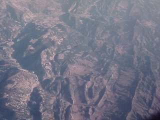 |
A fold several kilometers across in western Turkey. Is it a syncline or an anticline? |
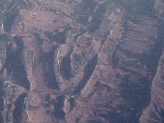 |
This closeup of the fold helps determine what type it is. When valleys cut across dipping layers, they provide three-dimensional information. The outcrop pattern of the bed forms a V shape that points in the direction of the dip. The beds here are dipping in toward the center of the fold, hence, it's a syncline. |
 |
An anticline in north-central Pennsylvania. The outer surface of the ridge is a folded layer of resistant rock. Softer rocks beneath have been eroded away to create a valley. Within that is a second ridge formed by the next lower resistant layer. In the very core of the anticline (right) is a small isolated valley formed where the soft rocks in the center of the fold were eroded away. |
 |
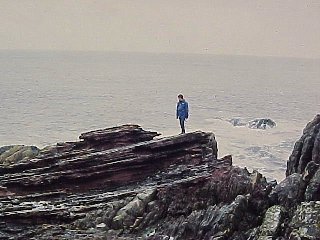
Here, not far from Harrisburg, Pennsylvania, we see a v-shaped ridge at the end of a fold. |
 |
A well-exposed fold in Virginia. |
 |
A small structure in Wyoming, a few kilometers across. The dark red layers can be traced all the way around it. The V's formed where ravines cut the layers show that the layers are dipping outward, therefore the structure is a dome. But not a simple one. It's more triangular than circular, and there's a small basin superimposed on it at left center |
Folds and Foliation
 |
When objects of known shape deform, they are valuable indicators that allow us to quantify rock deformation. Fossils are good indicators. The light spot here is a reduction spot, a place where iron in the rock was chemically reduced and the reddish color of the slate bleached. The originally round spot (the object in the center that locally affected the rock chemistry is visible) has been deformed into a nearly perfect ellipse. The rock has been flattened in the direction of the short axis and lengthened in the direction of the long axis. |
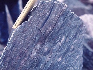 |
Deformed rocks develop a sheetlike structure called foliation. one way foliation can form is simply by flattening existing strucures in the rock. This rock near Gander, Newfoundland was once a conglomerate - granitic pebbles have been flattened by over 50 per cent but the black slate pebbles have been flattened almost paper-thin. |
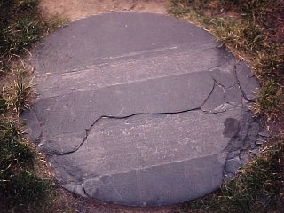 |
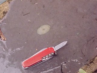
Foliation is not bedding. This slate paving stone near Independence Hall, Philadelphia was split along a foliation surface, but weathering has revealed the original bedding in the rock. |
 |
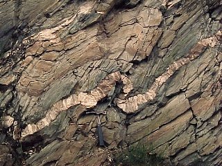
Some foliation forms when materials are removed from the rocks by solution. The fine parallel cracks in this fold formed that way. The solutions move in the direction of least resistance, parallel to the axial plane of the fold. |
 |
Marble rarely develops a foliation, but some is weakly visible in the rocks on this hillside in Vermont. The layers on top of the hill are nearly horizontal, curve through vertical beneath the two standing figures at left, and dip about 30 degrees to the right on the bottom of the hill. The layers on the bottom have been tilted through the vertical and overturned - they are upside down. Such a fold is called an overturned fold. A fold where the axial plane is nearly horizontal (and this is close) is called recumbent.
The geologist at left in the blue shirt is Walter Alvarez, best known for discovering the evidence that an asteroid impact led to the extinction of the dinosaurs. |
 |
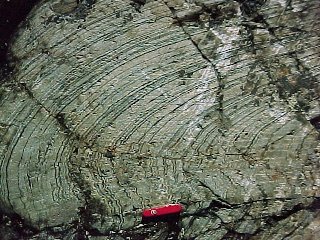
This outcrop near Rutland, Vermont has several interesting features. Several minor folds are visible, the foliation is parallel to their axial planes, and the thickness of the beds measured parallel to the axial planes is nearly constant. But the granitic sill looks quite different. It is much more rigid than the enclosing slate and deforms in a very different manner, it maintains a fairly constant thickness. Note how the foliation deviates within the small folds in the granite - the rocks there are being pinched as the granite folds and the stresses there will have little connection with the regional stresses that are folding the rocks. Note that the folds are Z-shaped, indicating an anticline to the right. |
 |
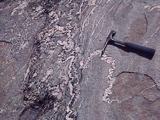
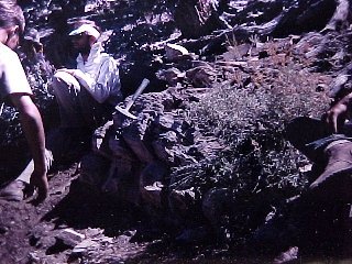
The upper surface of this outcrop in Ontario is a bedding plane. There is a crude foliation dipping to the left, suggesting the fold is an anticline with its crest off somewhere to the left. Also visible in the rock are several elliptical objects. They differ very slightly from the surrounding rock and are visible only as a result of weathering. One is just left of the hammer, another above and right of the hammer. Note that their short axis is perpendicular to the foliation. When we have several deformation indicators in the rocks, they usually tell a consistent story. |
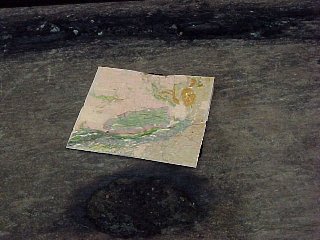 |
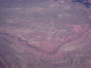
This is why these small structures are important. At the bottom is another of the elliptical objects, visible because it weathered faster than the adjacent rock. The geologic map above it shows the Sudbury Basin, the pink oval with the green center. The outcrop is within the Sudbury Basin.
The Sudbury Basin is an ancient meteor crater, originally circular. It was deformed by a crustal event, as were the rocks within it. The ellipse in the rocks, a foot long, has the same shape as the Sudbury Basin, which is about 50 miles long. |
Multiple Deformation
 |
Rocks can be folded more than once, as these gneisses near Sudbury, Ontario were. |
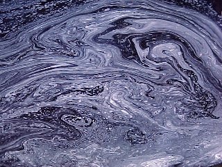 |
Really complex deformation in rocks can produce patterns as complex as the swirls in this foam on a stream, and events in one area don't necessarily tell you anything about events elsewhere. |
Other Geologic Deformation
 |
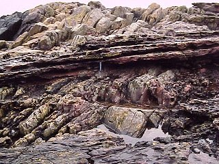
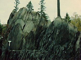
The beds at the top of the hill are a sequence of Cambrian limestones about 30 meters thick. This locality is east of Bishop, California. A fault cuts the left side of the mountain, so the series of prominent beds on the top of the hill and the beds on the left flank of the hill are the same. |
 |
About 50 kilometers to the south, these rocks are intruded by a geologically famous intrusion, the Papoose Flat Pluton. The limestones, being very ductile, were pushed out of the way and stretched, but never pulled apart. Because of the sparse vegetation in this region, the rocks can be followed almost continuously as they thin out. At their thinnest, they are only a meter thick. The entire limestone sequence is visible here, and even the color variations in the limestone are preserved. |
 |
When rocks are compressed, they often are extended at the same time in some other direction. The granite dike cutting this gneiss near Bucksport, Maine has been stretched until it broke into a series of discrete blobs, a process called boudinage (from the French word for sausage.)
This is also a nice example of the adage "don't get mad, get even." The geologist mapping this area wanted to call the gneiss the Knox gneiss, but was told he could not because there was already a Knox Formation elsewhere in the U.S. (the U.S. Geological Survey will not recognize duplicated names). So he turned to a local Indian place name and called it the Passagasawakeag Gneiss. |
Return to Course Syllabus
Return to Course Notes Index
Return to Professor Dutch's Home Page
Created 18 September 1998, Last Update 23 January 2001