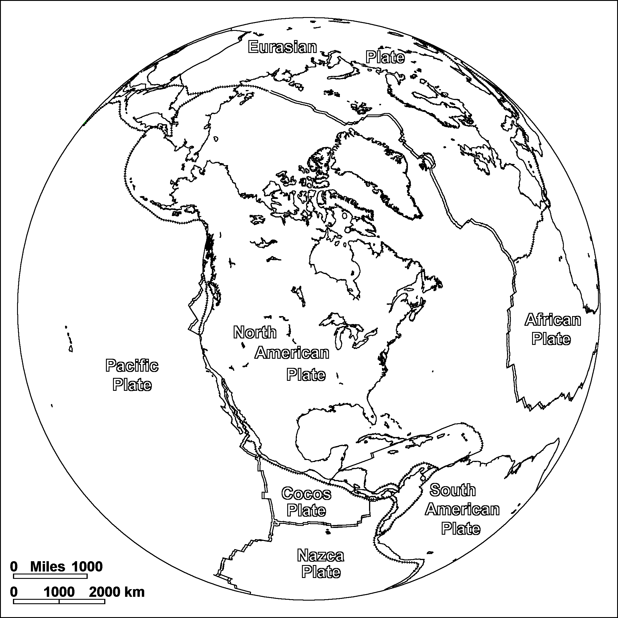
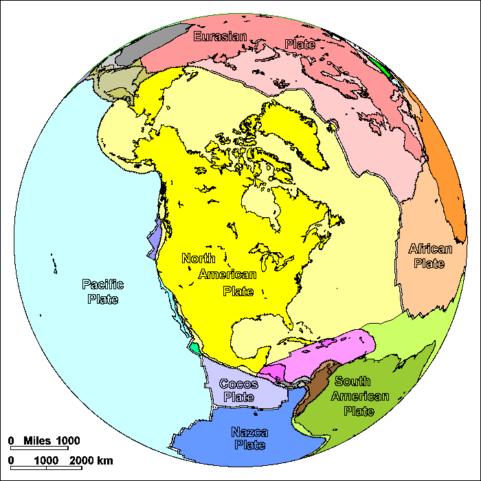
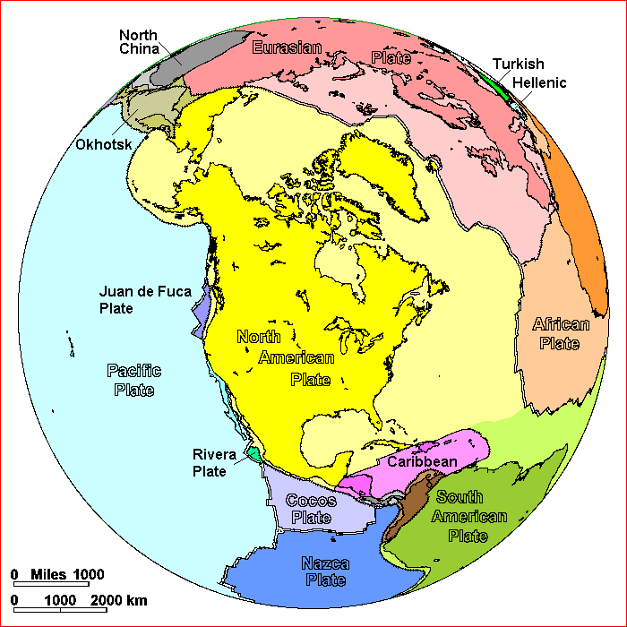
North American Plate
Steven Dutch, Professor Emeritus, Natural and Applied Sciences, University of Wisconsin - Green Bay
On these diagrams, pairs of parallel lines show boundaries where plates are spreading apart, lines with ticks show boundaries where plates are colliding, and simple lines show other types of boundary. These include places where plates are simply sliding past one another, places where motions are too complex to portray simply, and places where new plate boundaries may be forming.
North America, Greenland and Eurasia were once part of Pangaea. The east coast of North America was attached to West Africa. This northern portion of Pangaea has been called Laurasia and was separated from Gondwanaland by a large wedge-shaped sea, the Tethys. (The name Laurasia is a blend of Laurentia, from the St. Lawrence River, and Eurasia.) Laurasia began to break apart from Gondwanaland about 180 million years ago. Greenland and Eurasia broke off about 80 million years ago.
The earth has two kinds of crust. The continents are mostly made of thick granite. When continents pull apart, the gap is filled by thin crust made of basalt. In plate tectonics, a continent is any piece of continental crust surrounded by oceanic crust or plate boundaries. Greenland is a continent. When North America and Europe began to pull apart about 80 million years ago, Greenland originally moved as part of Europe for about 20 million years. Then the crust broke on the east side of Greenland, leaving it attached to the North American Plate.
Note that the North American Plate also includes part of Siberia. Notice the way the boundary between the North American and Eurasian Plates changes from divergence to convergence. The two plates are actually opening like a hinge and the pivot is in northeastern Siberia. On the far side of the pivot, the plates converge.
The mid-ocean ridge in the Pacific, the East Pacific Rise, is bounded on the east by the Cocos and Nazca Plates. When North America was further east, the East Pacific Rise extended all the way to Alaska and the Nazca, Cocos and Juan de Fuca Plates were a single large plate, which geologists call the Farallon Plate. About 30 million years ago North America came into direct contact with the Pacific Plate and the Juan de Fuca Plate was cut off from the rest of the Farallon Plate. Today only a small remnant of it remains. It is still being subducted under the Pacific Northwest, creating occasional earthquakes and the volcanic activity of the Cascade Range.
Was any plate ever attached to the west side of North America? Probably, but more than half a billion years ago. There is evidence for a pre-Pangaea supercontinent called Rodinia that existed then, with North America at its center. The plates to the west may have included parts of Siberia, Australia, or Antarctica. Ever since about 300 million years ago, the western margin of North America has been a subduction zone, which has swept up roughly 200 terranes. Virtually all of Alaska, the Canadian Rockies, Nevada and California are built up from accreted terranes.
On the south, Mexico and Central America are made of small plates. Tracking their motions is extremely difficult because so much of Mexico is covered by young volcanic rocks and the floor of the Gulf of Mexico is deeply buried by sediment that hides records of plate motion. It is generally agreed that Mexico and Nicaragua were further northwest and Yucatan filled the present Gulf of Mexico. Costa Rica, Panama, and the large islands of the Caribbean are not ancient continental crust but are the result of accumulation of volcanic and sedimentary rocks at long-lived subduction zones.
Possible Coloring
Labeled Features
In addition to the large plates, significant small plates are labeled. Very small plates are not labeled.
Return to Geology Coloring Book Index
Return to Professor Dutch's Home Page
Created 25 July 2009, Last Update 15 January 2020