Near Ice Maximum (14 Ka)
Steven Dutch, Professor Emeritus, Natural and Applied Sciences, University of Wisconsin - Green Bay
Near Ice Maximum (14 Ka)
Start Series
Previous (Earlier)
Next (Later)
View Text
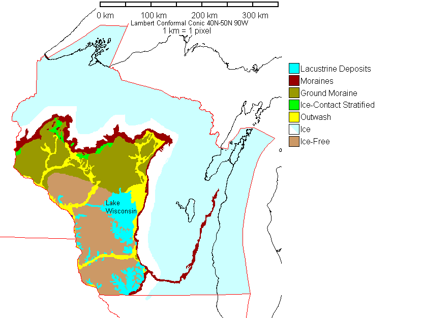
The actual Wisconsin ice maximum was at about 18,000 years ago. This map shows a slightly later position where the main recessional moraines were developed. The ice was apparently diverted around the Lake Superior Highlands and spread into Wisconsin as several lobes. From west to east they are the St. Croix Lobe (along the Minnesota border), Chippewa, Wisconsin Valley, Langlade, Green Bay (very long lobe in eastern Wisconsin), Delavan (near Illinois border) and Lake Michigan Lobes. Moraines between the latter three lobes form the Kettle Moraine complex.
The large lake in central Wisconsin is Glacial Lake Wisconsin. It formed when the ice blocked the Wisconsin River near Portage and drained west to the Mississippi. Failure of the ice dam, a characteristic of ice-dammed lakes, allowed the lake to drain catastrophically, cutting the channels and rock forms of Wisconsin Dells.
Return to Geology of Wisconsin Index
Return to Professor Dutch's Home Page
Created 27 Dec 1997, Last Update 11 January 2020