Halfway to the Pole
Steven Dutch, Professor Emeritus, Natural and Applied Sciences, University of Wisconsin - Green Bay
There are several markers in Wisconsin and upper Michigan that mark the halfway point between the equator and North Pole (why does the pole seem so much closer most of the time?) Interestingly enough, there are two different ways to define halfway, and there are markers for both methods.
Door County: 45 North
There are two virtually identical markers along State Highways 57 and 42. The Highway 57 marker is north of Jacksonport and the Highway 42 marker is south of Egg Harbor.
Highway 42 Marker
 |
 |
Highway 57 Marker
 |
 |
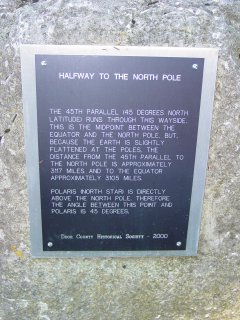 |
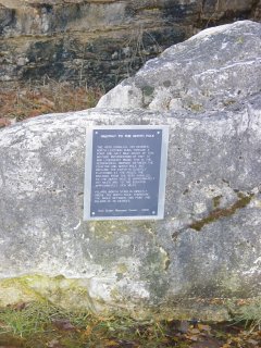
The 45th parallel (45 Degrees North Latitude) runs through this wayside. This is the midpoint between the equator and the North Pole. But, because the earth is slightly flattened at the poles, the distance from the 45th parallel to the North Pole is approximately 3117 miles and to the equator approximately 3105 miles. Polaris (North Star) is directly above the North Pole. Therefore, the angle between this point and Polaris is 45 degrees. |
Peshtigo: 45 North
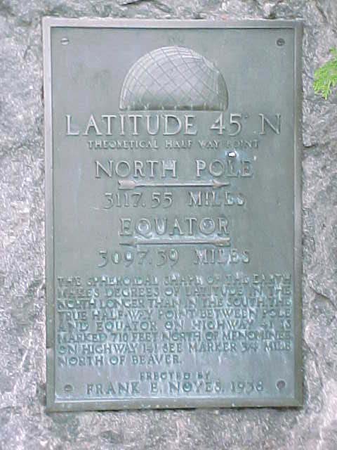
This marker, about 10 km southwest of Peshtigo on US 41, uses the simplest definition, 45 degrees north, but it refers to two other markers for a different definition. The inscription reads:
- Latitude 45 North
- Theoretical half way point.
- North Pole 3117.55 miles
- Equator 3097.39 miles.
- The spheroidal shape of the earth makes degrees of latitude longer in the north than in the south. The true half-way point between pole and equator on Highway 41 is marked 710 feet north of Menominee.
- On highway 141 see marker 3/4 mile north of Beaver.
- Erected by Frank E. Noyes, 1938.
 |
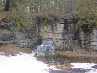
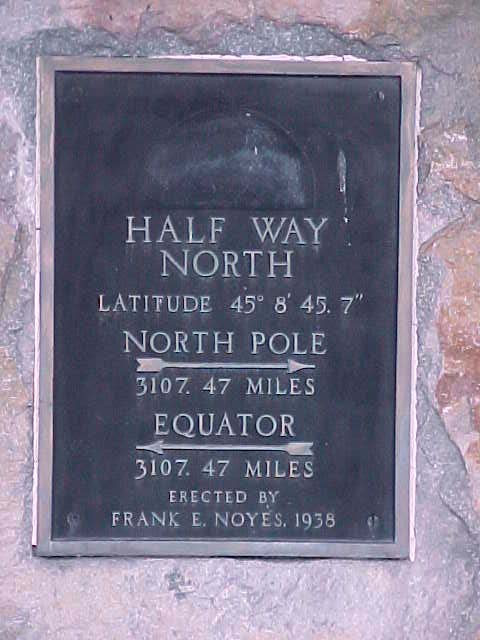
This is the other marker, on US Highway 141 at Beaver, about 5 km north of Pound. It is located just north of highway 64 on the right (west) side of the road. The latitude is not 45 degrees, as you'd expect, but 45 degrees, 8 minutes, 45.7 seconds. The discrepancy is due to the ellipsoidal shape of the earth, so that degrees of latitude are slightly shorter at low latitudes than high. It is 3107.47 miles to both equator and pole. The inscription reads:
|
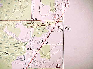 |
The location map conceals some very complex ideas about maps and the size and shape of the Earth. The triangulation point marked "Goddard" is the geographic marker. Note just off the margin of the map the number 5000 (the first two digits are smaller). What's that for? |
When the metric system was set up, the meter was defined so that the distance from the equator to the pole would be exactly ten million meters or 10,000 kilometers. Maps, especially military maps, use a grid system called the Universal Transverse Mercator Grid System (UTM for short), that covers the earth with squares a kilometer on a side. Ideally, halfway between the equator and pole is 5000 km. The last two digits are larger because many users use only the last two digits (if you're working in a small area, do you really need to know how far it is to the equator?)
So why isn't the geographic marker exactly at the 5000 mark? For openers, the dimensions and oblateness of the earth weren't known precisely enough when the metric system was set up. The mileage given on the marker, 3107.47 miles, equals 5000.99 kilometers, so the actual distance from equator to pole is more like 10,002 kilometers. Not bad for 200 years ago, however. Also, the grid depends on what mathematical model is used for the shape of the Earth. Grids on Russian maps don't coincide exactly with grids on NATO maps because they use a slightly different model for the shape of the Earth.
But there's another problem. The highway marker is 5001 kilometers from the equator. So why is the marker south of the 5000 mark? It should be north of it.
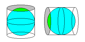 |
Recall that the UTM system covers the earth with a square grid. But squares won't cover a sphere. The TM part - Transverse Mercator - means that the earth is projected onto a Mercator Projection that wraps around the earth in a north-south direction (right) instead of the familiar east-west wall map style (left). |
Mercator projections are notorious for exaggerating areas near the poles, so to avoid distortions, the earth is broken up into zones six degrees wide, each of which has its own grid. Within such a narrow area, the Mercator Projection is quite accurate; the maximum scale error is 1/1000. Western Wisconsin lies in a grid zone that extends from 90 to 96 degrees west. Eastern Wisconsin lies in a grid zone that extends from 84 to 90 degrees west.
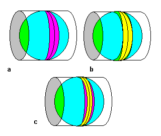 |
The center of the zone for eastern Wisconsin is 87 degrees west. If we were simply to wrap our Mercator projection cylinder around the earth along 87 degrees west, the scale would be correct along 87 degrees west but slightly too large everywhere else. The cylinder would touch the earth along 87 west and nowhere else (a). If we were to make the scale correct along 84 and 90 degrees, the cylinder would be inside the earth everywhere else and the scale would be too small (b). |
The best compromise is to fit the scale so that the errors are minimized everywhere in the zone by having the cylinder partly within and partly outside the earth. That is, the scale is correct about halfway between the edges and center of each zone, a little large outside and a little small inside (c).
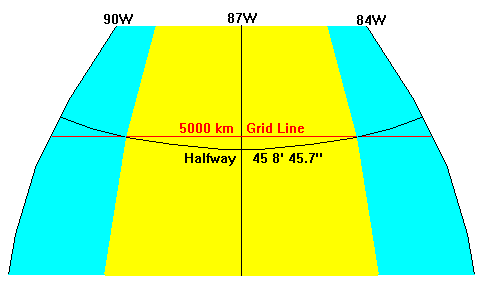
The figure above shows how the grid relates to latitude. In the blue areas, the projection cylinder extends outside the earth and the scale is slightly too large. In the yellow areas, the projection cylinder lies within the earth and the scale is slightly too small. The scale is true along the boundary between the two areas. Parallels of latitude bow equator-ward relative to grid lines, so the 5000-km grid line is south of the halfway latitude on the edges of the grid zone and north of it in the center.
Menominee, Michigan
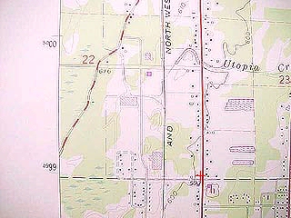 |
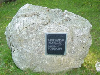
A virtually identical marker is located in Menominee, Michigan, on US Highway 41 just north of 48th Avenue. Here we are about half a degree of longitude east of the marker at Beaver and the discrepancy between the halfway marker (red cross) and the 5000-km grid line is a full kilometer. |
- The inscription reads:
- Half Way North
- Latitude 45 8' 45.7"
- North Pole 3107.47 miles
- Equator 3107.47 miles
- Erected by Frank E.Noyes, 1938
Suring
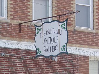 |
I have been told there is a marker in Suring but haven't seen it. It does, however, boast the 45th Parallel Antique Gallery. |
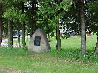
Near Edgar, 45 N, 90 W
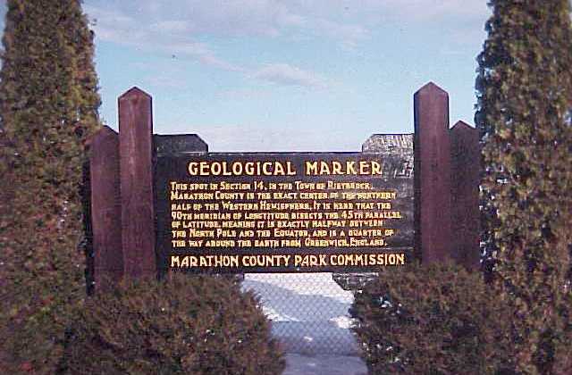
A county wayside between Edgar and Athens holds this marker, for some odd reason called a "Geological Marker." It marks the center of the west half of the northern hemisphere. By amazing coincidence, that's also the center of the north half of the western hemisphere. Either way, it's 45 degrees north, 90 degrees west. A sign on State Highway 29 near Edgar marks the turnoff. The turnoff is about 2.5 km west of county H on Cardinal Lane. The wayside is about 6 km north of Highway 29. The monument reads:
This spot in Section 14, in the town of Rietbrock, Marathon County, is the exact center of the northern half of the western hemisphere. It is here that the 90th meridian of longitude bisects the 45th parallel of latitude, meaning it is exactly halfway between the north pole and the equator, and is a quarter of the way around the earth from Greenwich, England.
Cadott (45 North)
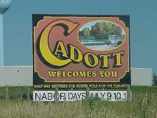 |
Cadott, near Chippewa Falls, avoids the complexities by billing itself "Half Way Between the North Pole and the Equator" without getting bogged down in details. |
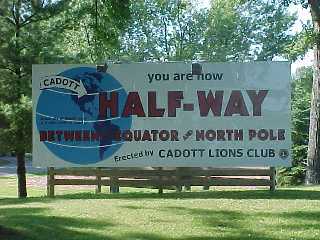 |
This billboard at a park in Cadott is equally non-committal. A note in small letters on the globe notes that the actual halfway point is three miles north of town. Reference to a map shows that their definition of "halfway" is actually 45 degrees. |
Return to Geology of Wisconsin Index
Return to Geologic Localities Index
Return to Professor Dutch's Home Page
Created 19 May 1999, Last Update 15 January 2020