Evolution of the Great Lakes
Steven Dutch, Professor Emeritus, Natural and Applied Sciences, University of Wisconsin - Green Bay
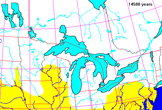
Based on maps in Geology and Economic Minerals of Canada, Geological Survey of Canada Economic Geology Report 1, 1970, pp. 714-725, modified from other sources.
White: Ice
Dark blue: Exposed water
Light blue: Present water bodies covered by ice
Yellow: Exposed land in the United States
Pink: Exposed land in Canada
Red: Boundaries
Black: Shorelines
Dark Purple: Marine inundation
Light Purple: Present water bodies inundated by the sea
Lake outlets are shown as thick blue lines with red arrows showing drainage direction
This list shows available maps. Figures are in years before present
14500 14000
13600 13200
12900 12700
12500 12200
12000 11800
11500 11200
10900 10600
10300 10000
09500 09000
08700 08400
08200 08100
07500 06000
An animation of the map series is shown below.
Return to Physical Geology Index
Return to Professsor Dutch's Home Page
Created 12 Sept 1997, Last Update 15 January 2020