What If? The Ice Ages Had Been A Little Less Icy?
Steven Dutch, Professor Emeritus, Natural and Applied Sciences, Universityof Wisconsin - Green Bay
First-time Visitors: Please visit Site Map and Disclaimer. Use"Back" to return he
Presented at the Geological Society of America meeting, Philadelphia, PA, October 22, 2006.
Abstract
The What If? historical book series explores the impact of historical events by presenting counterfactual scenarios, or alternative histories. Most geological events are too remote in time and too indirect in effect for a counterfactual approach to be any more than science fiction. One exception is the Pleistocene, which was recent enough and had dramatic impacts on human history. In this counterfactual scenario, I assume that the North American ice sheets never extended far below the Canadian border, and the Scottish and Scandinavian ice sheets never merged. The impacts of this alternative history include:
The Missouri River would not have been diverted into its present course and would probably have re-established its former drainage to Hudson’s Bay. The United States would have acquired a much smaller Louisiana Purchase, with no water route for Lewis and Clark to follow to the Pacific Northwest. The western boundary with Canada might well be far south of its present latitude.
2. The Ohio, and probably the Teays paleo-river, would not have been established. The St. Lawrence watershed might have extended far down the west side of the Appalachians. The Thirteen Colonies might well have been hemmed in to the west and confined permanently to the Atlantic Coast. There would be no Great Lakes and no Erie Canal. Without the Ohio and Missouri Rivers furnishing easy east-west water transport, American history would have been profoundly different.
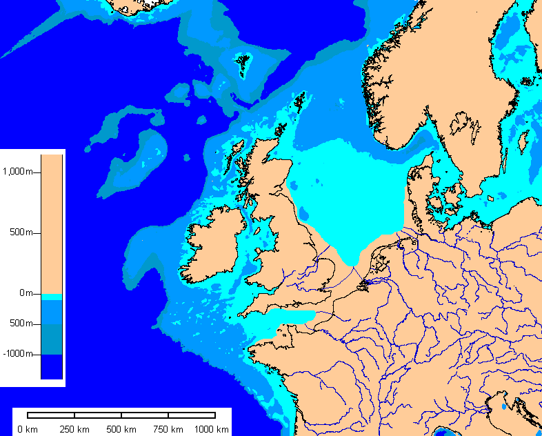
3. If the Scottish and Scandinavian ice sheets had not merged, the ancestral Rhine-Thames system would have flowed unhindered across the North Sea shelf, rather than seeking a new outlet to the west. There would be no English Channel, no defeat of the Spanish Armada, no water barrier to thwart Napoleon or Hitler. Britain might still be a formidable naval power, but with a land frontier as well, its cultural and political independence would have been far less secure.
In conclusion, two relatively small changes in Pleistocene paleogeography would have profoundly changed Western history.
Introduction
Counterfactual history is the attempt to envision history as it might have been if some key event had played out differently. Apart from alternative histories written purely as fiction, there are more serious works as well. Counterfactual histories, of course, cannot be tested experimentally, but they serve to illustrate the significance of events by speculating how history might have been different had the event not happened as it did. Frequently counterfactual histories are used to underscore the importance of a relatively small but crucial event. In other cases they are used to critique or defend historical decisions by arguing that some alternative decision would plausibly have led to better or worse outcomes. For example, many historians speculate that failure of the D-Day landings, or early defeat of Britain in World War II, would have led, not to Nazi victory, but to Soviet domination of Europe. In another essay, Richard B. Frank argued that, had the atomic bomb not been used against Japan, the projected invasion would either have been called off as impossible, or failed catastrophically. The only way to force surrender would have been blockade and destruction of Japan's rail network, resulting in mass starvation. Generally, the most serious counterfactual analyses restrict themselves to first-order consequences.
For the most part, counterfactual geology would be little more than science fiction. If the dinosaurs had not died out or Pangaea had broken apart differently, it would be impossible to extrapolate the effects on human history with any confidence. If plate convergence had not closed off the eastern Mediterranean, Columbus wouldn't have needed to sail west, but long before that, human history would have been changed in so many ways it's impossible to speculate in a meaningful way. Although there have been many geological disasters throughout history, few if any had any decisive impact on a major historical event.
One geological event - possibly the only one - that may lend itself to productive counterfactual analysis is the Pleistocene glaciation. By reshaping geography in recent prehistoric times, the Pleistocene profoundly affected human history. I intend to argue that some relatively small changes in the Pleistocene ice configurations in North America and Europe could plausibly have led to radically different historical outcomes.
The purpose of this study is not to present alternative history as something scientifically testable. Rather, the purpose is to illustrate how geology affects humanity. Rather than merely describing the role of the English Channel in European history or the Mississippi River system in American history, this study seeks to illustrate their significance in a more unconventional way: by showing that slight changes in their evolution might well have created a completely different world.
World 1.0
North America
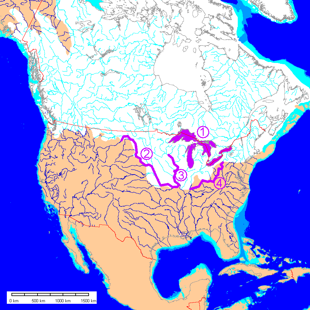
The most historically significant effects of Pleistocene glaciation in North America (present drainage shown). On all maps, Pleistocene sea level is assumed to have been 100 meters lower.
- Excavation of the Great Lakes
- Diversion of the Missouri River
- Diversion of the upper Mississippi River
- Diversion of the Ohio River
Europe

Although the creation of the Baltic Sea was very important for the history of Europe, by far the most historically significant effect of the Pleistocene was the formation of the English Channel. A large proglacial lake was impounded by the ice, and discharged westward across a low drainage divide to cut the Strait of Dover.
Of nearly equal historical importance are the Bosporus and Dardanelles between the Black Sea and the Mediterranean. Although Pleistocene eustatic and proglacial lake discharges may have played a role in their evolution, it is not clear what effect different ice configurations might have had on their formation. They are therefore not considered in this study.
There were many local diversions of rivers in northern Europe around ice margins. However, the ice never blocked major drainage divides as in North America, and there was no continent-scale drainage rerouting. Maps of Europe show present drainages with no attempt to reconstruct paleodrainages.
World 1.1
North America
In this counterfactual scenario, I assume the ice never advanced far into the continental United States, or completely blocked the St. Lawrence. Mountain glaciation may have occurred in the Adirondacks and northern New England. In keeping with a reduced-ice scenario, a complete open corridor between the Laurentide and Cordilleran ice sheets is shown.
Europe

In our counterfactual world, the ice caps never merge, at least not enough to impound water high enough to top the Dover paleo-divide. In the map above the ice caps do not meet. An alternative map below shows ice caps joined, but not enough to allow overtopping of the drainage divide.
No Missouri River?
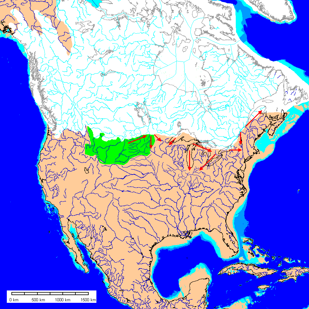
In this reduced-ice scenario, probable pre-Pleistocene drainages are shown. The upper Missouri River basin remains ice-free (green). Impounded proglacial lakes would probably have found outlets as shown by the red arrows. Even more importantly, river valleys in present day Montana and the Dakotas would not have been filled in by glacial deposits.
Paleodrainages are based on Bluemle (1983), Flint (1955), Herzog and others (1994), Indiana Geological Survey (2006), Iowa Geological Survey (1991), Ohio Geological Survey, 2003 and my own interpretations. Maps of paleovalleys for many areas show cross-cutting valleys, so clearly there were multiple diversions and ice-marginal drainages. Paleodrainage histories are incompletely known in many areas and frequently interpreted differently by different authors.
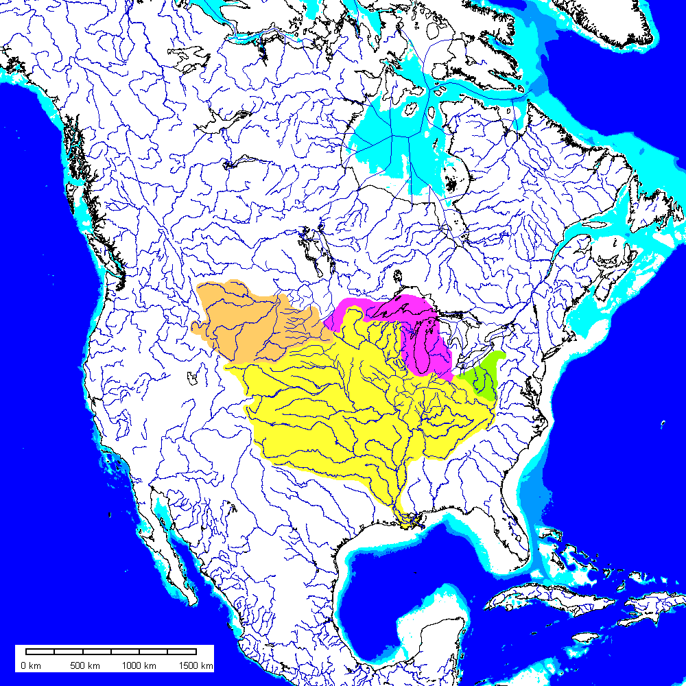
The map above shows how present drainage systems might be different in the counterfactual world. With no blockage of the ancestral Hudson Bay-Mississippi drainage divide at high elevations, plus less infilling of valleys by glacial deposits, it would have been far easier for the ancestral upper Missouri River to re-establish its course into Canada. The area shown in orange would be lost to the Mississippi drainage system. The area shown in green is a minimal estimate of drainage to the St. Lawrence that would not have been diverted. The Ohio River is discussed below. Magenta indicates areas around the present Great Lakes that might have remained connected to the Mississippi drainage had the Great Lakes not been excavated. This area is highly speculative but is intended to suggest that not all the drainage diversions were one-way. The Mississippi gained drainages from Pleistocene diversions, but also may have lost drainages.
Implications For American History
- One feature of American history not likely to have been greatly affected would be the arrival of humans in North America. Even if the corridor between the Cordilleran and Laurentide ice sheets was completely ice-free, it takes time for species to expand their range, even humans. It is unlikely that humans were in a position to enter North America much sooner than they actually did
- The United States would have acquired a much smaller Louisiana Purchase
- There would have been no easy water passage to carry Lewis and Clark to the Pacific
- The United States would have had no claim on the upper Missouri by purchase, and no claim on the Pacific Northwest by discovery. Oregon, Washington, Idaho, Montana, and the Dakotas might have remained British and later, Canadian.
- With the Black Hills in Canadian hands, might the conflict with the Lakota have been avoided?
- Or would American gold seekers have poured into the Black Hills anyway? Would attempts to control the influx have led to armed conflict and perhaps even war between the U.S. and Great Britain?
- If the United States even extended this far west, that is….
No Ohio River or Great Lakes?
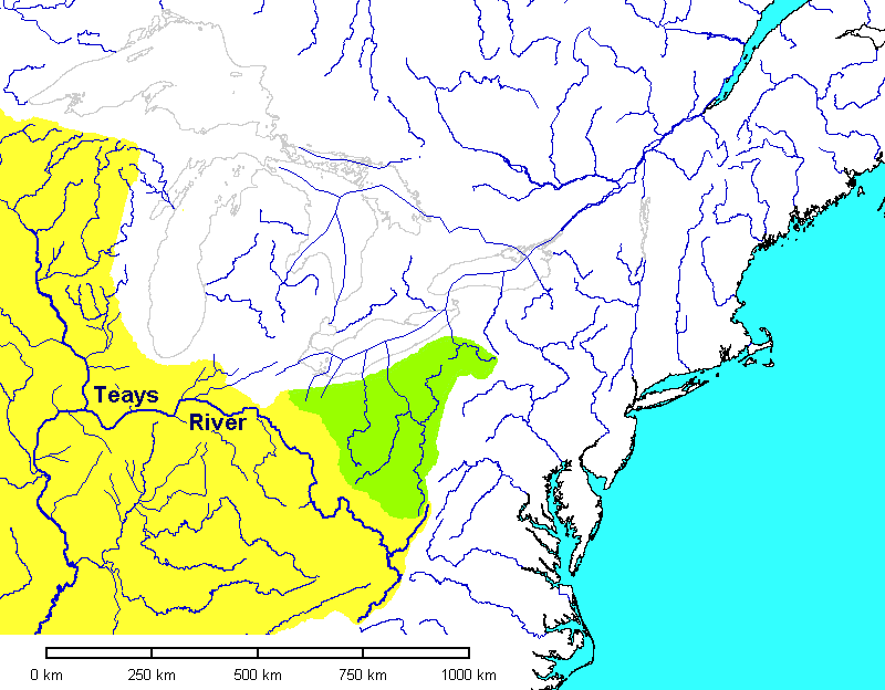
The importance of the Great Lakes to American history can hardly be overstated. If the ice sheets had never advanced deeply into the U.S., there would be no Great Lakes, no Erie Canal, no easy water access into the interior. Chicago, Milwaukee, Detroit, Cleveland, Buffalo and Toronto would not exist in their present forms.
The pre-Pleistocene Teays River (Coffey, 1961; Hansen, 1987; Melhorn and Kempton, 1991; Stout and Lamb, 1938; Ver Steeg, 1946) would not have been diverted, nor would the Alleghany drainage (green). The Niagara River would have followed its pre-Pleistocene course. There would be no Niagara Falls and possibly the St. Lawrence would be navigable far into Ohio. Pittsburgh might still be an important city, but valued for its access to the St. Lawrence, not the Ohio.
The easiest access to the Mississippi drainage (yellow) would be a much harder route across the Appalachians in Virginia. With access to headwaters of both Mississippi and St. Lawrence streams, the commercial center of gravity in the U.S. might have been in the Mid-Atlantic States.

The Teays River itself has the look of something assembled by a committee, and perhaps is the product of earlier Pleistocene diversions. If a northern route across Ohio suggested by some authors were re-established after ice retreat, the headwaters of the St. Lawrence would have been in North Carolina. In this scenario, the axis of transportation west of the Appalachians would be northward. With access from Canada so much easier, this region might have remained solidly Canadian, possibly even French. The Thirteen Colonies might have remained hemmed in along the Atlantic coast.
The easiest access from the east coast to the Mississippi would have been via tributaries of the Tennessee River, a much less navigable route than the present Ohio. Would access to the Mississippi have been as pressing an issue for Americans? Would there have been as great an incentive to purchase the Louisiana territory? With the Mississippi serving mostly to permit entry from its mouth into the interior, rather than a funnel carrying commerce from its upper reaches to the sea, would New Orleans have had its strategic importance?
If there were even a United States or England at all…..
No English Channel?
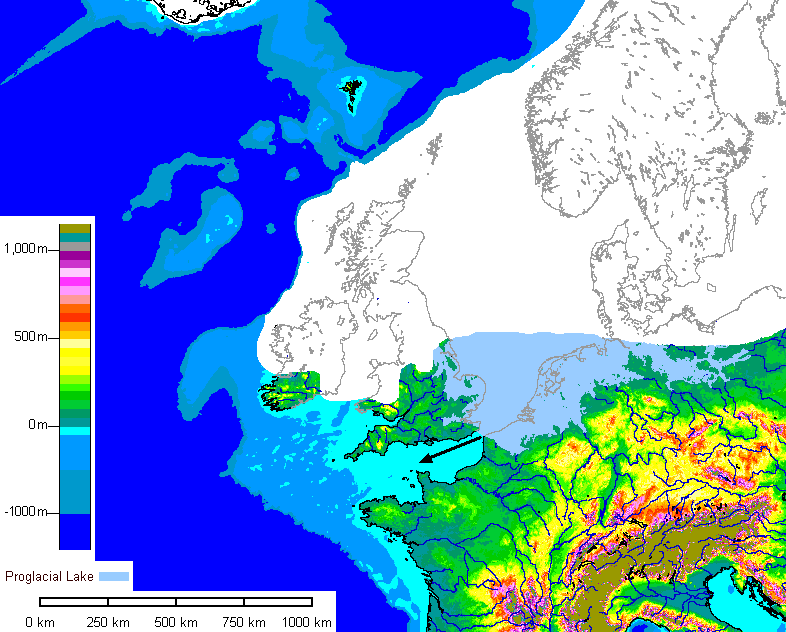
In the world we know, the Scandinavian and British ice caps merged during the penultimate glacial maximum and impounded a large proglacial lake, shown here with ice retreated somewhat from maximum. The lake topped a low drainage divide and incised the Strait of Dover and the English Channel (Gibbard, 1998, 1995, 2006; Gibbard and Lautridou, 2003). Some authors suggest a catastrophic, Scablands-type flood (Gupta and others, 2005).
In our counterfactual world, the ice caps never merge, at least not enough to impound water high enough to top the Dover paleo-divide. In the map above the ice caps do not meet.
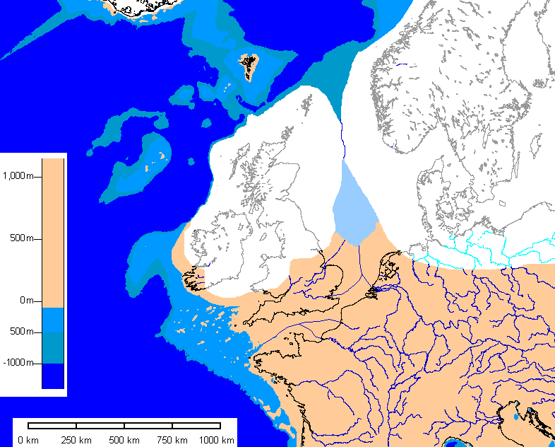
In the alternative map above, the ice caps join but impounded lake water drains over or through the ice and never overtops the drainage divide.
As a result, southern Britain retains its pre-Pleistocene coastline and remains attached to the mainland.
Imagine European History With No English Channel
- England might well have become a formidable naval power, but with a land frontier to defend, it could not have poured its military energy so intensively into its navy.
- Even if it could successfully have defended its land frontier, the frontier would have been culturally far more porous. We can wonder whether England would have maintained its cultural identity as well as it did.
- Would the Romans have occupied Britain during Caesar's campaign in Gaul instead of a century later?
- Could England have stopped the Spanish in 1588?
- Could England have stopped Napoleon in 1805?
- Could England have stopped Hitler in 1940?
- How many other invasions would have been attempted if Britain had remained connected to the mainland?
- Without its legendary navy, would England have been able to project power globally as effectively as it did?
- Might the race for colonies have been slowed? Spain conquered the Americas while Britain was a minor power, and the French had a formidable navy. With France, in particular, in a better position to challenge Britain for naval supremacy, the global arrangement of colonies might have been quite different.
References
Bluemle, J. P., 1983; Geologic and Topographic Bedrock Map of North Dakota, map MM-25 1983, 1 pl. (1:670,000), North Dakota Geological Survey
Coffey, G. N., 1961; Major preglacial, Nebraskan, and Kansan glacial advances in Ohio, Indiana, and Illinois: Ohio Journal of Science, v. 61, p. 295-313.
Flint, R.F., 1955; Pleistocene geology of eastern South Dakota: Washington, D.C., U.S. Geological Survey, U.S. Government Printing Office, Professional Paper 262, 173 p.
Gibbard, P.L. 1988; The history of the great north-west European rivers during the past three million years. Philosophical Transactions of the Royal Society of London B318, 559-602.
Gibbard, P.L. 1995; Formation of the Strait of Dover. In: Preece, R.C. (ed.) Island Britain - a Quaternary perspective. Geological Society Special Publication. No.96, 15-26.
Gibbard, P. L. and Lautridou, J. P., 2003; The Quaternary history of the English Channel: an introduction, Journal of Quaternary Science, v. 18, no. 3-4, p. 195-199. <http://dx.doi.org/10.1002/jqs.743> accessed 13 October 2006.
Gibbard, P., 2006; History of the northwest European rivers during the past three million years: A series of palaeogeographical maps illustrating the evolution of the northern European drainage system over the last 3 million years. Quaternary Palaeoenvironments Group, University of Cambridge. http://www-qpg.geog.cam.ac.uk/research/projects/nweurorivers/ (Accessed 13 October 2006)
Gupta, S., Collier, J., Potter, G, and Palmer-Felgate, A., 2005; Catastrophic flood geomorphology in the English Channel compared with Martian outflow channels, Geophysical Research Abstracts, Vol. 7, p. 10803
Hansen, M. C., 1987; The Teays River: Ohio Division of Geological Survey, Ohio Geology, Summer, p. 1-6.
Herzog, B.L., Stiff, B.J., Chenoweth, C.A., Warner, K.L., Sievering, J.B., Avery, C., 1994; Buried Bedrock Surface of Illinois, 1: 500,000, Illinois Map 5. Digital Edition: 1.0 available at <http://www.isgs.uiuc.edu/nsdihome/browse/statewide/bedtopo.e00> Accessed 10 October 2006.
Indiana Geological Survey, 2006; Indiana Bedrock Topography Map, <http://igs.indiana.edu/geology/maps/statebedrock/topography.cfm> Accessed 13 October 2006
Iowa Geological Survey, 1991; Bedrock Topography of Iowa, <http://www.igsb.uiowa.edu/inforsch/brtopomp.htm> Accessed 5 October 2006
Melhorn, W. N., and Kempton, J. P., eds., 1991; Geology and hydrogeology of the Teays-Mahomet bedrock valley system: Geological Society of America Special Paper 258, 128 p.
Ohio Geological Survey, 2003; Shaded bedrock-topography map of Ohio, <http://www.dnr.ohio.gov/geosurvey/pdf/oh_btmap.pdf> Accessed 5 October 2006
Stout, W. and Lamb, G. F., 1938; Physiographic Features of Southeastern Ohio, Ohio Journal of Science, v. 38, March 1938, no. 2, p. 49-83
Ver Steeg, Karl, 1946, The Teays River: Ohio Journal of Science, v. 46, p. 297-307.
Return to Professor Dutch's Home Page
Created 2 November 2006, Last Update 24 May 2020