Planes: The Three-Point Problem
Steven Dutch, Professor Emeritus, Natural and Applied Sciences, University of Wisconsin - Green Bay
Recall that any three points determine a plane. If you have three points on a plane, you can find the plane. In a geologic application, the three points can be outcrops, elevations encountered in drilling, and so on.
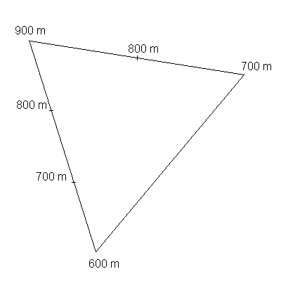
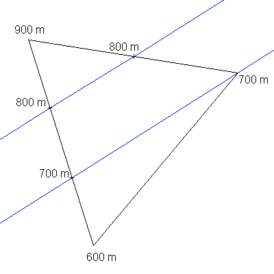
| The key to the problem is to recall that linear interpolation always works between two points in a plane. If we have three points whose elevations are known, we can find the elevations of any points on the lines between them. |  |
|
Once we have one or more pairs of points at the same elevations, we can draw structure contours. If your construction determines a number of contours, they MUST be parallel and equally spaced. You may find that if there's one short contour that just nicks a corner of the triangle, it's not quite parallel to the others. This is almost always due to construction errors, which are magnified by the small size of the construction. Don't put much emphasis on that contour, and never, ever base any important conclusion on it. |
 |
Interpolation
As usual, real geologic data are rarely so neat. You must be able to interpolate when the data are not in round numbers.
Say you have two points at 924 and 677 meters. You will want to locate the 900, 800, and 700 meter points between them. On the map, the line between the two points represents a vertical difference of 924-677 = 247 meters. The 700 meter point lies (700-677)/(924-677) = 23/247 = .093 of the way from point 677 to point 924, the 800 meter point 123/247 or .498 of the way, and so on.
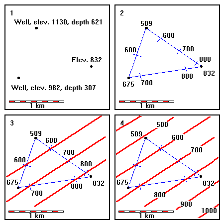
CAUTION! One of the most common errors in this sort of problem is confusing depth below the surface with elevation. If you have well data, you MUST convert it to an elevation before doing this construction. If you have a bed at 300 m depth in a well, and the wellhead is at 800 m, the elevation of the bed is 500 m.
Example
 |
1. The problem. Construct the structure contours on this bed, given three elevations. 2. Interpolate between the three pairs of points. Note how the well data were handled. 3. Construct structure contours between matching elevations. 4. Construct additional contours parallel and equally spaced. |
Return to Course Syllabus
Return to Techniques Manual Index
Return to Professor Dutch's Home Page
Created 5 January 1999, Last Update 12 June 2020