Plot Map Trace And Elevation Points on a Line
Steven Dutch, Professor Emeritus, Natural and Applied Sciences, University of Wisconsin - Green Bay
Linear Structures in Geology
Lines are simpler than planes in most respects but harder to visualize. They are less often encountered in structural geology than planes. Many planes are more or less "real": bedding planes, dikes, sills, joints, faults. Lines tend either to be included within a plane (sedimentary structures, metamorphic mineral alignments) or determined by the intersections of planes (bedding and fault planes, opposing limbs of a fold). We rarely encounter structures that are purely linear - boreholes are perhaps the most common example.
For every line in space, there is a vertical plane that contains the line; that is, the line lies entirely within the plane. If the line is a geologic structure, we define the trend of the line as the azimuth of the vertical plane, in the direction the line descends. Unlike strike, which can have one of two directions, trend is defined uniquely.
The angle the line makes with the horizontal, measured in the vertical plane, is called the plunge
Plotting Map Trace And Elevation Points
This is a very simple problem. The map trace is just a line on the map directly above (or in some cases below) the plunging line. It obviously has the same azimuth as the trend.
We can mark the plunging line with points of equal elevation in one of two ways, we can draw a cross-section in the vertical plane that contains the line:
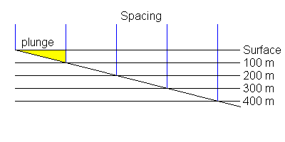
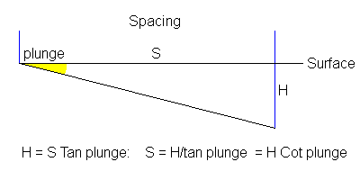
Or we can determine the spacing of the points trigonometrically:
If this all looks familiar, it is. It is exactly the same procedure we used to find the spacing of structure contours. If you think about it, finding elevation points on a line that plunges down the dip of a plane is the same thing as finding structure contour spacing.
Example
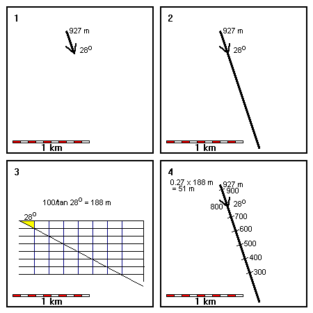 |
1. Plot the map trace and elevation points of the fold axis shown 2. Draw the map trace through the outcrop and with the same azimuth as the trend. 3. Determine spacing of elevation points using a cross-section or trigonometry. 4. Plot elevation points |
Return to Course Syllabus
Return to Techniques Manual Index
Return to Professor Dutch's Home Page
Created 5 January 1999, Last Update 12 June 2020