Intersection of Geologic Structures and Topography
Steven Dutch, Professor Emeritus, Natural and Applied Sciences, University of Wisconsin - Green Bay
This problem is one of the more complex geometrical problems in geology because of the myriad combinations possible. We are trying to find the intersection of two surfaces. The land surface is approximately horizontal but with irregularities. Fortunately these irregularities consist of a few basic types of landforms. The geologic structure will probably not be as irregular. To start with, let's consider the intersection of planar structures with topography.
- Beds that are horizontal will have contacts at constant elevations. The contacts will coincide with or be parallel to topographic contours (above left).
- When structures are vertical, a map view looks along the surface of the structure. Structures cross topography without deviating (above right).
- Dipping planes fall somewhere in between these two extremes. The shallower the dip, the more the contacts follow contours. The steeper the dip, the less the influence of topography.
Effects of Varying Dip
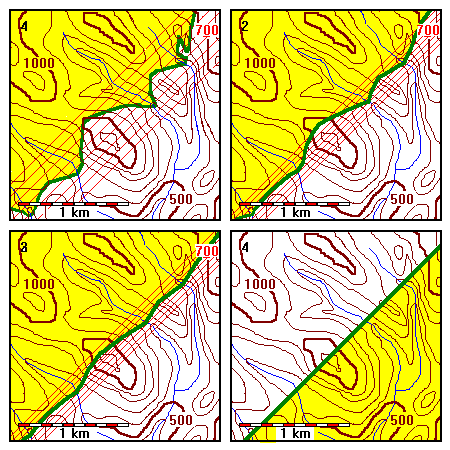
In the series of maps below, the intersection of a planar contact and topography is shown. In every map the topography is the same but the dip of the contact differs. Topographic contours and structure contours on the contact are at 100-meter intervals. The contact is in green and the rocks below the contact are in yellow. In every map the strike of the plane is 045 degrees and the location of the 700-meter structure contour is the same. In effect we rotate the plane around the 700-m structure contour and observe the effects of varying dip.
Dip Opposite Topographic Slope
In the series of maps shown here, the topography slopes generally southeast but the contact dips northwest. The spacing of structure contours decreases by half from one map to the next.
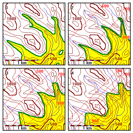 |
1. Horizontal
2. Dip 9 NW 3. Dip 17 NW 4. Dip 32 NW |
 |
1. Dip 52 NW
2. Dip 68 NW 3. Dip 79 NW 4. Dip Vertical |
Note that the contact makes a V as it crosses ridges and valleys. The V points downdip where it crosses valleys. This is because the valley, being lower than the ridges, cuts the plane further down the dip than the ridge crests.
Dip Direction Same As Topographic Slope
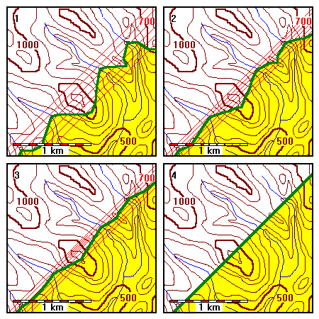
In the series of maps shown here, the topography slopes generally southeast, and so does the contact. The spacing of structure contours decreases by half from one map to the next.
 |
1. Horizontal
2. Dip 9 SE 3. Dip 17 SE 4. Dip 32 SE |
Life is rather more complicated here. In Map 2 the contact dips down-valley, but the contact makes a V (not a very obvious one) pointing upvalley. Then in Map 3 the V flips around and points downvalley.
In Map 2 the dip of the bed is very nearly equal to the slope of the valley floors. It's just a hair less, so the contacts eventually close upvalley. If the slopes were exactly equal, the contact would run along the valley walls at a constant elevation above the valley bottom.
In Map 1 the contact also makes V's pointing upvalley; that's the characteristic behavior of topographic contours. The V rule of dipping contacts actually applies to the dip relative to the valley or ridge being crossed. It's rare for valley bottoms and ridge crests to have very steep slopes, so most of the time on geologic maps contacts form V's pointing downdip as they cross valleys. In Map 3 the plane is steeper than the topography so the V points in the direction we expect.
Note that between Maps 2 and 3 the yellow area abruptly flips from SW of the contact to NE. The reason is that the regional slope of the topography is somewhere between 9 and 17 degrees SW. In Map 2 the plane has shallower slope than the topography but in Map 3 the plane is steeper than the topography.
 |
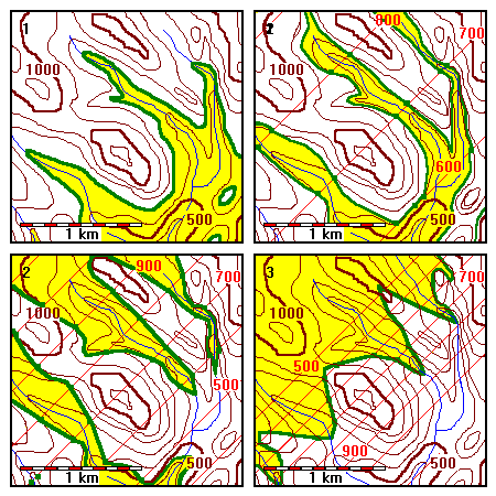
1. Dip 52 SE
2. Dip 68 SE 3. Dip 79 SE 4. Dip Vertical |
In the series of maps above the the contact is always steeper than the topography so the V points in the direction we expect.
Complex Structures and Topography
On a scale of kilometers or larger, topography is pretty insignificant compared to the vertical dimensions of geologic structures. When dip equals 45 degrees, the horizontal deviations of a contact will be equal to the topographic relief (can you see why?). Even if the topographic relief is a couple of kilometers, the effect on a fold ten kilometers across will be pretty minor. On a 1:250,000 map the effects of topography are almost negligible, except for nearly-horizontal beds that follow topographic contours. Deviations of contacts on large-scale maps are more likely to be due to the geometry of the contact itself rather than to topography. Nevertheless, the map may still show topographic effects that indicate dip direction and are useful for visualizing the three-dimensional geometry of the rocks.
On small-scale maps, however, topography may cause the contacts of rock units to deviate considerably, possibly even obscuring the structure if the topography is very steep or complex. In such cases, you can use local contact relationships, plotted strike and dip symbols, and V directions of contacts to help visualize the structure. It may be necessary to plot structure contours on selected contacts.
Return to Course Syllabus
Return to Techniques Manual Index
Return to Professor Dutch's Home Page
Created 17 March 1999, Last Update