Contour Topographic Data
Steven Dutch, Professor Emeritus, Natural and Applied Sciences, University of Wisconsin - Green Bay
To predict the intersection of geologic structure with topography, you have to understand topography.
Basic Rules of Topographic Contours
- Contours are lines of equal elevation. All points on a contour are at the same elevation.
- They never terminate (although they may go off the edge of the map. Also, they may be omitted in certain situations for clarity, as in the case of a steep slope where the contours bunch together). Contours always close eventually. The one-meter contour may circle all the way around Europe, Africa and Asia, but it will close.
- They never cross (the only exceptions, overhanging cliffs or natural arches, are so rare that they have no practical importance.) If contours crossed, it would mean the same point had two different elevations.
- They never branch or split.
Basic Landforms
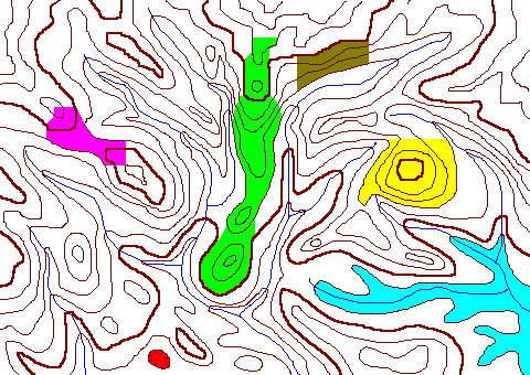
- Slope (Brown)
- The steeper the slope, the closer the contours, because it takes less distance to rise or fall a given amount on a steep slope.
- Hill (Yellow)
- Contours are concentric with maximum elevations in the center
- Valley (Blue)
- Lower elevations in the center. Contours form V's that point upstream.
- Ridge (Green)
- An elongate hill. Elevations high in the center. Contours form V's pointing downhill.
- Depression (Red)
- Uncommon, and usually shown with hachured contours. The hachures are on the downhill side.
- Saddle (Purple)
- The landform that confuses more beginners than any other. Land slopes downhill in some directions, uphill in others. Any time you have four elevation points, with the points on one diagonal high and the other low, you probably have a saddle.
How to Contour Data
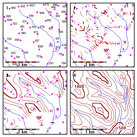 |
1. Contour the elevation data shown.
2. Interpolate between nearby points. Also locate elevations along streams and valley bottoms. 3. Connect the most obvious segments of contours first. 4. In areas of sparse data, you may have to draw contours approximately. |
Additional Pointers
- Valley slopes tend to be parallel to streams.
- On a ridge, hilltops are unlikely to be round. They are more likely to be elongate and parallel to the ridge.
- Often there is insufficient data to decide whether two contours on either side of a saddle join or not, or whether an isolated high spot is a hill or a small spur. In such cases there may be several equally correct ways to contour the data.
Some Common Mistakes to Avoid
In each pair of maps below the left map is incorrect and the right map is correct. There may be other ways to contour the data that are equally correct, however.
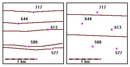 |
Interpolate
The map on the left is of no use to anybody. Beginners often draw contours through each elevation point. Don't! Use only even contour intervals and interpolate between points to locate the contours. |
 |
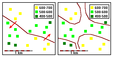
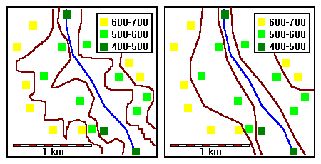
Water flows downhill. A contour can only cross a valley if the valley floor is at that elevation. This map shows the stream flowing over a hill! |
 |
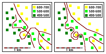
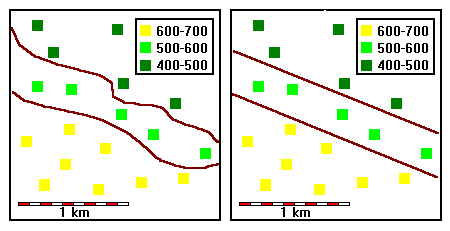
Slopes must be consistent across a contour. This error is especially common around saddles. |
 |
Do not end, cross or branch contours. These errors tend to occur when the mapper mismatches contours when joining them up, or cannot figure out how to connect sections of contours. |
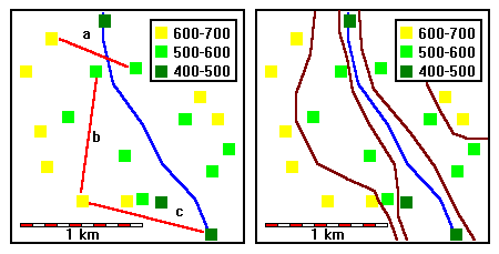 |
Do not interpolate across valleys (a) or between very distant points (b), or any time you suspect the slope is not approximately constant (c). |
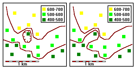 |
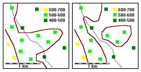
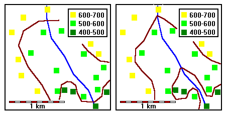
Depressions are relatively rare. Do not draw them unless you have real evidence that they exist. Although both maps are possible, the map on the right is much more plausible. |
 |
Do not make the contours any more complex than the evidence requires. There is no evidence for any of the small detail on the left map. |
 |
Draw V's wherever contours cross streams, and make sure they point the right way! Both maps are consistent with the data but the right map is much more likely to occur in nature. |
 |
Do not vary contour spacing or curvature unless you have positive reason to do so. This problem usually stems from poor hand-eye coordination while drawing. It's better to depart a bit from perfect interpolation than to have contours with irregular spacing or curvature. |
Return to Course Syllabus
Return to Techniques Manual Index
Return to Professor Dutch's Home Page
Created 17 March 1999, Last Update