Outcrop Patterns Involving Inliers and Outliers
Steven Dutch, Professor Emeritus, Natural and Applied Sciences, University of Wisconsin - Green Bay
Inliers and Outliers
Not every outcrop problem produces a simple, neat line on the map. Very often there are disconnected areas of outcrop
An Outlier is an outcrop outside the main exposure area. An Inlier is an outcrop within the main exposure area, exposed through a window in the overlying rocks.
- Any time you have a structure or topographic contour that blocks you from connecting two outcrop areas, you are probably dealing with outliers or inliers (at least within the map area -- they may connect outside the map area).
- Always be prepared for outliers near hilltops and inliers near valley bottoms.
- Any time new points suddenly appear on a structure contour, be prepared for a possible inlier or outlier.
- Any time your outcrop band shows deep re-entrants, you may have outliers or inliers. The available evidence may not be sufficient to tell for sure.
- Sometimes even a thin layer will coincide with the land surface and outcrop as an area rather than a band. The clue that this may be happening is a structure contour that coincides closely with a topographic contour.
Example
This is exactly the same map used to illustrate outcrop patterns in areas of complex topography. The only difference is that the structure contours are 100 meters higher.
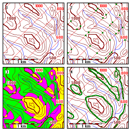 |
1. Find the outcrop pattern of the coal seam whose structure contours are shown in red. 2. Locate intersections of like contours. 3. Intervals where the outcrop can be are shown in purple. Topography is higher than the coal seam in yellow areas and lower in green. Note some purple areas are completely disconnected. 4. Draw the outcrop band. Start with simple areas, locate obvious ridge and valley crossings, then finish difficult areas. |
Comments
The coloring scheme used in (3) is useful in extremely complex areas to help keep track of where the outcrop can occur. It shows that the topographic and structure contours intersect to form boxes, often very irregular ones, and that the outcrop band enters at the lower corner and exits at the higher one.
Any time you see a purple band bounded on one side by green and on the other by yellow, the outcrop must pass between the contours. The reason is that the topography spans an entire contour interval and therefore must intersect the bed somewhere in that interval. This is fairly obvious when the two pairs of contours enclose a fairly neat box, but it applies equally well in all situations. It tells you, for example, that the outcrop must pass around an isolated hilltop, for example.
Saddles are inherently ambiguous. In the northeast corner a small hilltop is shown as surrounded by an outcrop band. The coloring shows us that the topography in that area spans an entire contour interval, therefore it must intersect the bed somewhere. Thus the outcrop must pass around the outside of the hill. What cannot be determined is whether the outcrop is connected to the main outcrop band, disconnected as shown, or perhaps just barely connected. There's no right or wrong answer in many cases, we just have to examine the data and draw the most likely configuration.
The saddle in the left-center of the map is shown as separating two outcrop areas, but in fact they could connect. There are three possibilities: the outcrops could form two separate loops as shown, the outcrop could enclose the pair of hills in a peanut-shaped curve, or the areas could just barely touch in the saddle to form a figure-8. This happens when the saddle just barely grazes the rock unit.
If the saddle is deep and wide, the chances of the outcrop passing through the saddle are greater. If the saddle is shallow and narrow, they are less. The closer the saddle is to the upper structure contour, the more likely it is that the outcrop passes through the saddle. Since the saddle in the left-central part of the map is wide and neatly straddles the structure contour interval, the outcrop is drawn as two separate loops.
In the extreme southwest corner there are two disconnected outcrop areas. The coloring in (3) shows they cannot connect directly. However, we see from the map coloring that the map is incomplete. The outcrop band must also pass down the purple band just left of the scale bar. The 900-meter topographic and structure contours appear to intersect again just outside the map area. The upper outcrop band should pass through that intersection and turn south to re-enter the map area. It could connect to the lower band somewhere outside the map area.
Return to Course Syllabus
Return to Techniques Manual Index
Return to Professor Dutch's Home Page