Tri-State Field Conference 1980 Trip 3: Environmental Geology Of The Green Bay Area
Steven Dutch, Professor Emeritus, Natural and Applied Sciences, Universityof Wisconsin - Green Bay
Ronald D. Stieglitz, Thomas H.Mcintosh, and Donn P. Quigley
Field Trip Overview
Development and land use In the vicinity of the city of Green Bay is influenced by geological, glacial and geomorphological elements. The most striking is the Silurian Escarpment or the "Ledge" as it is called that wasobserved on yesterday's Paleozoic and Pleistocene field trip. Other features,perhaps of greater significance, include: the bedrock underlying the FoxRiver Valley, large areas of sand and gravel outwash, low-lying glaciallacustrine lake plains of clay, unconsolidated shore bluffs along parts ofthe eastern bay shore, several large streams that flow through the urbanarea, the bay itself and large areas of wetlands along its shore.
The dolomites and outwash have long been quarried and as the city grew theextractive Industries have been brought into direct contact with residentialdevelopment. Lake clays present problems for waste disposal. The bay andthe streams are subject to flooding at times and in addition some stretchesmust be dredged for navigation. Disposal of the dredge spoils, paper millssludge, and large amounts of flyash from the coal-fired power plant on thebay shore are continuing concerns. We will visit or cross some of thesefeatures on this field trip (Figure 1).
Differences in land use are abrupt and are correlated with land forms and soils. As we progress along the route we will encounter first marsh andmade land (fill), outwash, moraines and beach ridges or combinations resulting from reworking by various post-glacial lake stages, and finally thelarge glacial lake plain. The northern part of the tour area, marsh andoutwash/beach ridge area, is dominated by sandy material ranging from excessively to poorly drained with organic accumulation (mucks). As we move south we cross a small area of till ridges and plains and descend ontothe northern end of a large glacial lake plain. The intensity of agricultural use for row crops, provides a clue to soil fertility and physical conditions.The sandy areas are used mainly for wood lot, housing, some horticulturalcrops and pasture. As clay content of the soil increases, agriculturalintensity also increases. This relationship is most striking as one entersthe lake plain area. In a dairy region such as this perhaps the best indicator of agricultural value is the number of modern large silos per unitarea of land.
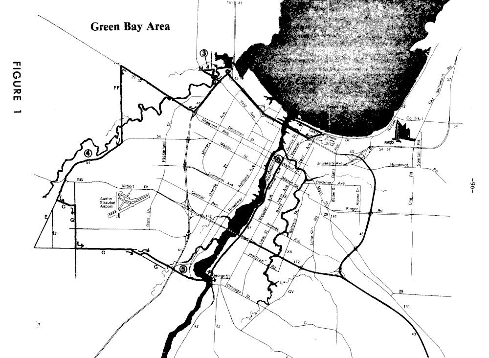
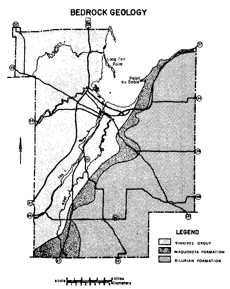
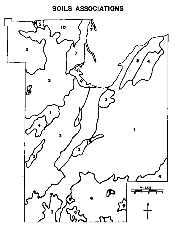
Figure 3. Generalized soil associations of Brown County, Wisconsin
- Kewaunee-Manawa
- Oshkosh-Manawa
- Shawano-Boyer-Sisson
- Waymor-Hochhelm
- Onaway-Solona
- Oshkosh-Allendale-Tedrow
- Tedrow-Roscoimnon
- Namur-Summerville-Kolberg
- Carbondale-Cathro-Marsh
- Shawano-Tedrow-Roscommon
Stop 1: Bay Beach Park and Wildlife Sanctuary
Dredge spoil disposal facility; storm dike and bay shore. Private claim 29, T24N, R21E, City of GreenBay, Wisconsin. Green Bay East 7.5-Minute Quadrangle.
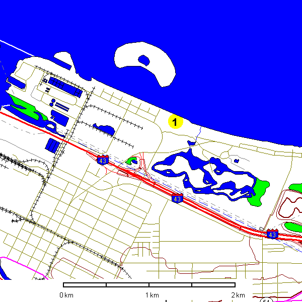
This area was all wetland and subject to flooding. During periods of strongstorms from the north, water is forced toward the head of the bay resultingIn flooding of the bay shore and of the residential and Industrial areaalong lrwin Avenue to the south. The rise on which we are standing andwhich extends east and west along the shore from this point is a dike builtto prevent this flooding.
The area from the edge of the bay south beyond the new Interstate has beenused as a dump for paper mill waste. A now abandoned municipal landfillsite is located about one mile to the east at the Intersection of East ShoreDrive and Danz Avenue. Other areas have been filled for Industrial purposes.Native soils range from 60% clay to over 807, sand, where former shore features are present, to organic mucks. The trees are relatively young andsecond growth.
A short distance offshore is the new dredge spoil containment island.Unofficially this is referred to as Renard isle, after the man of the samename who was president of the Harbor Commission for 10 years. It is 55acres in area and capable of holding approximately 920,000 cubic meters ofmaterial. Only maintenance dredge material may be placed in this area. Theapproximate life span of this facility is 10 years. The wall of the containment area contains approximately 110,000 metric tons of rock. The wallis about 2 meters across at the top and roughly 5 meters at the base. Itwas constructed to be about 3 meters above Low Water Datum and at the present time is about 2 meters above the existing level. The rock is placedaround sheet steel piling which while not waterproof prevents solids fromescaping. There are 3 filter cells (sand) that the effluent runs throughbefore entering the waters of the bay.
One important facet of this facility is a 1500 meter long 60 cm diameterpipe that runs from the mouth of the Fox River to the center of the containment area. The total cost of the project was $4,700,000 and of this amount,$1,000,000 represents the cost of the pipeline. The project was completedin June of 1980.
Route Description - Stop 1 to Stop 2
We will exit the parking lot and turn west (right) onto East Shore. Drive andproceed to the Green Bay Yacht Club Road. The large brown building on thesouth side of the road is the Municipal Sewage Treatment Plant. A largediameter pipe carries sewage from the west side of the city underneath theriver Into a sump below the plant. During construction of the tunnel, amethane explosion killed four workers and necessitated a change in the slopeof the excavation in order to avoid the gas filled material. Park in thepublic lot along the river.
Stop 2 Mouth of the Fox River
Green Bay harbor and industry; coal fire power plant, dredge spoils pipe. East edge of Private Claim 45, T24N,R21E, City of Green Bay, Wisconsin. Green Bay West 7.5-Mlnute Quadrangle
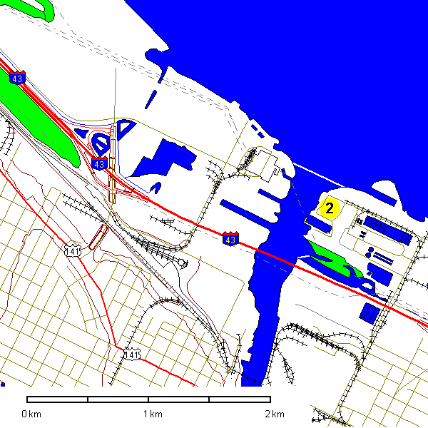
This is the confluence of the Fox River with Green Bay and the dischargepoint for a drainage basin of over 16,700 km2. The discharge of the riverhas been found to swing to the right as It enters the bay and to follow theeast shore for some distance before mixing completely with bay water. Circulation In the shallow lower bay is generally sluggish compounding waterquality problems. The ship channel In the lower bay and the river aredredged for navigation to a depth of about 8 meters. Both the new pipe,which carries spoils to the containment site seen at Stop I, and the headof the previously used pipe that carried them to the west shore wetlandscan be seen. The outfall pipe from the Metropolitan Sewage Plant is alsonear here.
Visible across the river is the Pulliam Power Plant belonging to the Wisconsin Public Service Corporation. The different smoke stacks documentthe sequence of additions to the plant as the demand for electricity increased. The plant burns coal and the resulting flyash has long presenteda problem of disposal. Much flyash and dredge spoils have been placed onthe wetlands along the west bay shore. Some of the filled areas are visiblein route to the next stop. New sites are now required and it is proposed toplace some in the quarry at Stop 3.
Route Description - Stop 2 to Stop 3
Upon leaving Stop 2, we will retrace our route on East Shore Drive to IrwinAvenue (County A) at Bay Beach. Turn right on Irwin and right again at thestop sign and move to left lane. If the new Tower Drive bridge over the FoxRiver is open we will turn left on the 1-43 west ramp and cross the river.If It is not open we will go straight and cross the river on the Main Streetbridge downtown. The following discussion is written assuming that theTower Drive bridge will be used.
The bridge, which rises over 35 meters above the water, provides a view ofthe area. Southward the lower Fox River and the center of the city of GreenBay are visible. Northward the lower bay can be observed. The water isvery shallow with depths outside of the ship channel of less than 4 metersthroughout the area between Long Tail Point on the west to Point au Sableon the east. There is a sand bar just beneath the surface extending fromnear the mouth of the Fox northeastward to Point au Sable. The entirelower bay freezes In winter. Beyond the entrance light water depths increaserapidly reaching depth in excess of 30 meters.
A complex set of glacial features form the higher land rising to the west.Outwash modified by post-glacial lake processes, and beach ridges provide acomplicated landscape. Soils range from tills on which Alfisols developedunder a mixed forest to sandy areas mainly of Entisols, Inceptisols and a fewweakly developed Spodosols.
West of the bridge, the highway crosses a part of the extensive wetlandsfringing the west bay shore. Portions of these marshes have been set asideas wildlife refuges where as other parts will soon be industrial park anddocks. Flyash has been disposed of In much of the area. In the northernpart of this area Spodosols have formed on moderately to poorly drainedsandy soils under conifers. The well drained to excessively well drainedsandy soils tend to be Alfisols or Entisols.
Stop 3 Duck Creek Quarry
Active quarry in the Galena Dolomite and proposed flyash disposal site; abandoned water-filled quarry containing wastewood material. SW 1/4, SW 1/4, Section 10, T24N, R20E. Brown County, Wisconsin. Green Bay West 7.5-Minute Quadrangle.
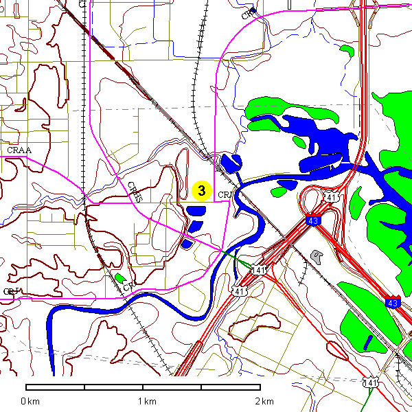
The quarries at this stop are in the Middle Ordovician Galena Dolomite. Therocks here consist of a gray coarse-grained, somewhat argillaceous dolomite.Fossils are numerous and include, trilobites, brachiopods, corals, andgraptolltes on some bedding planes. A glaciated striated and polished surface is present beneath till at the top of the quarry. We will be unable to actually enter the quarry but large blocks of the rock are present alongthe edge of the entrance area for inspection.
This quarry has operated for many years, however, it is now confined by roads,railroads, and buildings and is almost out of reserves of mineable rock.The quarry is scheduled to be used as a disposal site for flyash after It isclosed, raising some concern that the ground water may be affected.
A thin layer of lacustrine sediment, sandy In the upper part, covers thebedrock and in which is formed Tedrow loamy fine sand Entisol. This soilis somewhat poorly drained with minimal profile development. Southwest theland rises. Manistee fine sandy loam Spodosol is found in well drainedareas of sandy material. Kewaunee slit loam Alfisol has formed on tillsfarther upslope.
Across the road to the south is a water-filled quarry In which bark andwood chips were placed. The color of the water and the bubbles of methanebear evidence of their presence. Other abandoned and water-filled quarrieslie to the south and can be seen from County Highway HS on the way to thenext stop.
Route Description - Stop 3 to Stop 4
From Stop 3 proceed west on Glendale Avenue to the four-way stop. Turn leftat the stop sign back onto County Highway HS and return to Highway 41 south(note abandoned quarries). Go south on Highway 41 and exit at Highway 29west. Follow Highway 29 to County Highway FF. Turn south (left) on FF toHighway 54 and turn right to the landfill site at Stop 4.
West of the quarry, Glendale Avenue crosses Kewaunee "till soil" and entersonto an area of Oshkosh slit loam developed in lacustrine sediments at theIntersection with Velp Avenue. Velp Avenue crosses a small area of Kewauneesoil, a large area of lacustrine Tedrow soil and east of Duck Creek an areaof Manistee soil which also continues along Highway 41. Highway 29 westrecrosses Duck Creek, passes over Flatten Hill a ridge of till with Kewauneesoil, and then crosses an area of Waymore silt loam developed on till beyondthe intersection with County Highway J. The next rise is Burdon Hill onwhich the soils are a coarser member of the Waymore series. The soilsaround the Intersection with County Highway FF belong to the Manistee andShawano series, both sandy soils. The landforms on which these soils areformed are a complex of outwash, beach, ridges, and sand bars awaitingfurther study. South of County Highway J there is a large area of Briggsville silt loam, a soil formed in a thin layer of slit over calcareouslacustrine slits and clays. The soils along Highway 54 are mainly Briggsville and Waymore series. Note a variety of sandy knolls to the south.
Stop 4 West Brown County Landfill site
Waste disposal; Glacial landforms.SW 1/4, NE 1/4, Section 35, T24N, R19E. Brown County, Wisconsin. OneidaNorth 7.5-Minute Quadrangle.
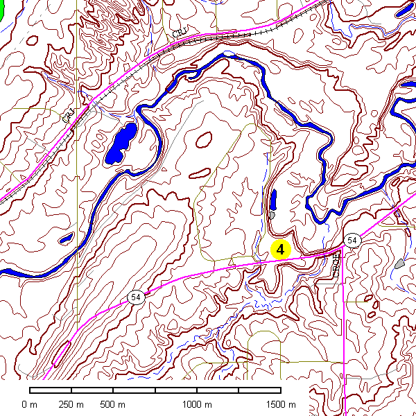
At this stop we will view a large modern landfill site. The facility islocated In an area of the thick outwash material near the northwestern margin of the lake plain. It has only recently opened, being proceeded by afacility located on the east side of the river immediately across Highway Xfrom Stop 6 of the Paleozolc and Pleistocene Field Trip. The DNR orderedpreviously used landfill sites to be abandoned by July 1, 1974 but whenreplacement sites were not ready In time the city continued to operate themIn violation of the order. The resulting litigation has only recently beensettled.
The soil materials at the landfill Include Kewaunee on the west side, Waymore In the center and Briggavllle on the extreme east. The best exposurewill be on the north side of the site which Includes Waymore slit loam.
Route Description - Stop 4 to Stop 5
From the landfill site we will exit west (right) onto Highway 54. At theeast edge of the Village of Onelda turn left onto County Highway E. Thishighway follows the crest of the southea.stern cravasse filling whichtogether with a similar feature to the northwest are known as the TwinRidges of Onelda. They extend for over 35 kilometers from northeast tosouthwest and rise more than 20 meters above the nearby landscape. DuckCreek flows northward between the two ridges to enter Green Bay just eastof Stop 3. The road provides a good view of the ridge as well as the FoxValley lowland to the east. The escarpment should be visible across thevalley.
About 3 miles south of Highway 54, we will turn east (left) onto FishCreek Road. We are in Outagamie County and this road becomes Brown CountyHighway G which we will follow Into De Pere.
The soils at the intersection of Highway 54 and County Highway E are of theOshkosh series formed In lacustrine parent material. South of County Highway G, the route crosses Kewaunee soil formed in till and then enters Outagamie County. The soils on the ridge top and upper slopes are now classifiedas Hortonville slit loam formed In till. This soil is coarser texturedthroughout than the Kewaunee which occurs farther downslope. Near theintersection with Fish Creek Road the soils become sandy and are formed inmaterial believed to be outwash or beach ridges. The soils at lowerelevations to the east along County G are poorly drained and formed Inlacustrine sediments but the area includes better drained knolls of Kewauneeand Waymore soils.
Just west of Ashwaubenon Creek and Highway 41 is an area of Oshkosh siltyclays followed by more sandy deposits. Pass beneath the highway and enterthe parking lots for Stop 5.
Stop 5 Big Boy and Country Kitchen Parking Lots
Sum up and departurepoint for participants going south or west. Private Claims 28/29 (SW 1/4,NW 1/4, Section 21). T23N, R20E, West De Pere, Wisconsin. De Pere 7.5Minute Quadrangle.
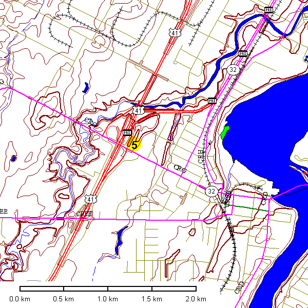
This site is located on the lake plain and is about one mile west of theFox River. We will attempt to answer questions and bid you farewell.
For those returning to Green Bay or with time to spare the following routemay be of Interest. Go east on Highway 32 across the Fox River. Turn southat intersection on east side of the bridge. Go about 1/2 mile to the smallpark and then right onto the road along the river beneath the bridge. Atthe first intersection beyond the bridge parking can be found and you canwalk onto the De Pere dam. When leaving, go east one block to Highway 57(Broadway) and turn left to Green Bay or right to travel south.
- Tri-State Field Trip: Northeastern Wisconsin
- Trip 1: Precambrian basement complex of northeastern Wisconsin
- Upper Ordovician and lower Silurian strata of eastern Wisconsin.
- Trip 2: Paleozoic and late Wisconsinan stratigraphy of eastern Wisconsin.
- Red till stratigraphy in eastern Wisconsin
- Trip 3: environmental geology of the Green Bay area.
- Trip 4: Green Bay metropolitan wastewater treatment plant tour.
- Trip 5: Structure and landform evolution in the Green Bay, Wisconsin area.
Return to Professor Dutch's Home Page
Created 31 August 2004, Last Update 13 January 2020
Not an Official UW-Green Bay site