Mountain Building and Crustal Deformation
Steven Dutch, Professor Emeritus, Natural and Applied Sciences, University of Wisconsin - Green BayIsostasy
 | Isostasy is the vertical movement of the crust to to bouyancy in the mantle. Just like blocks of wood in water float higher the thicker they are, the crust rises and sinks because it is lighter than the underlying mantle. |
 | Variations in elevation are due both to thickness and density. The continents stand high because continental crust is thick and light. The ocean basins are low because oceanic crust is thin and dense. |
The shorelines have nothing to do with the boundary between continental granitic crust and oceanic basaltic crust. There is a little more water than needed to fill the low areas, which are mostly underlain by thin basaltic crust, and some slops onto the edges of the continents.
If material is removed from the continents, by say, erosion, they will rise. If it is added, they will sink. The Pleistocene ice sheets, over three kilometers thick, caused the continents to sink by a kilometer. As the ice melted, the continents have risen again.
Isostatic Rebound Since the Pleistocene
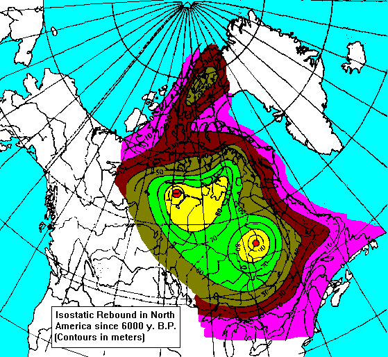
Isostatic Rebound in Canada
Isostatic Rebound in Scandinavia
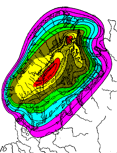
It's probably no accident that two of the largest epicontinental seas (seas extending deep into the continent) on Earth are Hudson Bay and the Baltic, both dead center in areas of active isostatic uplift. In all likelihood, the crust in these regions is still depressed and has not finished rising, and when uplift is complete both seas will mostly or entirely disappear. Gravity measurements suggest that the crust in the Hudson Bay region has another 100 meters still to rise.
Mountain Building (Orogeny)
Orogeny is the variety of processes that occur during mountain-building, including:
- Distinctive Patterns of Deposition
- Shallow-water sedimentary rocks on the inner side of the mountain belt, thick deep-water sedimentary rocks in the heart of the mountain belt. Thick accumulations of sandstone and conglomerate accumulate late in the history of the mountain range as it erodes.
- Deformation
- Folding and thrust-faulting
- Metamorphism
- Greenschist and amphibolite metamorphism (high pressure and temperature) in the core of the range, blueschist metamorphism (abnormally high pressure and low temperature) along its outer edge.
- Intrusions
- Granitic batholiths are usually associated with orogeny.
- Volcanic Activity
- Along the crest of the mountain range there is typically a chain of andesite volcanoes.
- Oceanic Trenches
- Along the outer edge of most currently active mountain belts is a narrow, deep oceanic trench.
- Seismic Activity
- Shallow great earthquakes along the inner wall of the trench, then deeper earthquakes along a planar zone dipping beneath the mountain range, reaching depths of up to 700 kilometers.
Why Mountains Form
Mountains form at subduction zones. Shown below is a true-scale cross-section of the Andean subduction zone in northern Chile (roughly 25 S).

The vertical change of 15 kilometers in only a few hundred kilometers distance is the largest elevation change on Earth in such a short distance. Plates consist not only of the crust, but about 150 kilometers of the underlying mantle as well. Collectively the crust and associated mantle are termed the lithosphere. Oceanic crust is typically 5 kilometers thick. The continental crust thickens from its normal 40 kilometers to 70 beneath the high Andes. When the descending slab reaches a depth of about 100 kilometers, it begins to melt, causing, directly or indirectly, many of the events associated with mountain-building.

Why Mountains are High
Mountains are high because orogeny shortens and thickens the crust, and isostasy causes the thicker crust to rise. Some of the processes are shown above:
- Even uniform materials, when compressed from one direction, tend to expand in the direction of least resistance.
- Layered rocks shorten by folding, but the stack of layers also becomes thicker.
- Thrust-faulting thickens the crust by stacking slices of crust atop one another.
- Intrusions add volume to the crust.
- A great deal of magma never invades the crust but accumulates at its base, a process called underplating.
- Where the crust is heated, thermal expansion causes the rocks to become lighter and more buoyant.
Anatomy of an Orogenic Belt
Shown here is a "simple" continent-ocean orogenic belt. We can divide an orogenic belt into parallel zones defined by their deformation, rock types, or metamorphism. These zones may approximately coincide with each other but somewhat overlap, so it's necessary to have distinct names for them.
Zones of Rock Types

Deep-Water Sedimentary and Volcanic Belt (Eugeocline)
On the outer edge of the orogenic belt we find great thicknesses of immature deep water sediment. Often these rocks show evidence of deposition in an unstable setting, such as evidence of submarine landslides. Accompanying these rocks are often submarine volcanic rocks.
Shallow Water Sedimentary Belt
The rocks of the inner part of the orogenic belt are typically shallow-water sedimentary rocks typical of a continental shelf, which become thinner toward the interior of the continent. Igneous rocks are uncommon. As the mountain belt rises, great thicknesses of sandstone and conglomerate are deposited on its flanks and frequently bury much of this region.
The Platform
The stable interior of the continent will often be covered with thin layers of shallow-water or terrestrial sedimentary rocks. This thinly-mantled region is the platform
The Shield
Areas where ancient crystalline rocks are exposed over wide areas are called shields. Every continent has at least one shield. The shield and adjacent platform together make up the craton. Driving from Green Bay to Wausau takes you from a platform into a shield.
Structural Zones

The Accretionary Prism
Sediment eroded from the orogenic belt accumulates in the trench and is intensely deformed as the plates converge. Like the wedge of earth ahead of a bulldozer, the sediment thickens until it is capable of resisting further deformation.
The Igneous Arc
When the descending plate reaches about 100 kilometers depth, it begins to melt. Magma invades the crust, creating batholiths and a volcanic mountain chain. The intrusions also produce metamorphism, and by making the crust more ductile, make it easier to deform. This is the belt of greatest deformation, metamorphism and igneous activity.
The Foreland
Here, metamorphism is mild but compression of the crust results in folding and thrust-faulting. Often this deformation is "thin-skinned", meaning that rock layers near the surface become detached from deeper layers much the way a carpet wrinkles when a piece of furniture is pushed over it.
The Craton
This is the stable interior of the continent.
Metamorphic Zones
One of the best indicators of former subduction is the presence of paired metamorphic belts, a belt of typical Greenschist and Amphibolite metamorphism flanked by a belt of Blueschist metamorphism.

Greenschist-Amphibolite Metamorphism
The rising magma from the descending plate heats the crust, resulting in greenschist and amphibolite metamorphism in the igneous arc. At very high temperatures, rocks become very dehydrated; even muscovite mica breaks down to potassium feldspar and amphibole to pyroxene. This sort of metamorphism, called granulite metamorphism, occurs deep in the crust just about everywhere simply due to the normal geothermal gradient. At 25 degrees per kilometer, the temperature at the base of the crust, 40 kilometers deep, is 1000 degrees C. Of course, unusually intense heating can cause it to occur at shallower levels.
Blueschist Metamorphism
At high pressures but low temperatures, rocks are metamorphosed to blueschist grade. The reason temperatures are abnormally low is that the descending slab is still cool and helps keep adjacent rocks cool as well.
Eclogite Metamorphism
At about 100 kilometers depth, pyroxene, olivine and plagioclase recrystallize to a denser form to produce sodium-bearing pyroxene and garnet. The result is one of the most beautiful of rocks, eclogite, a mass of light green pyroxene enclosing pink garnets.
Ancient Orogenic Belts
It takes about 20 million years to erode a mountain range flat. But long after the mountains themselves are gone, we can recognize belts of deep- and shallow-water rocks, batholiths, rock deformation, and metamorphism.
Structures in the Rocks
Small Structures
- Anticline
- Syncline
- Monocline
- Homocline
Large Structures
- Dome
- Basin
- Arch, Swell, Upwarp
Foliation
Foliation is a sheetlike structure that forms when rocks are deformed. As the figures show, it forms in a variety of ways, but in every case, the foliation is at right angles to the direction of greatest compression.
| a. Foliation can simply form when objects in the rocks are flattened. b. Foliation can form when flattening causes platy mineral grains to align, much the way toothpicks would be aligned when swept up by a broom. c. Solutions often remove large amounts of material from rocks as they are being deformed. The solutions move in the direction of least resistance. d. Elongate crystals grow in the direction of least resistance. e. Pockets of molten material may form during high-temperature metamorphism, and these may be flattened. This is one possible way banding in gneiss forms. f. Shear, like along a fault, also produces foliation. As the shear deformation becomes greater, the foliation becomes stronger and more closely aligned with the fault plane. | 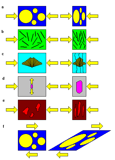 |
Folds and Foliation
On a small scale (microscopic to centimeters), foliation forms by a variety of mechanisms, but always at right angles to the direction of greatest compression
On a large scale (centimeters to kilometers), rocks fold. The axial plane of the fold is also at right angles to the direction of greatest compression
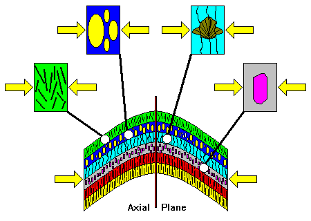
Therefore, foliation in deformed rocks is generally parallel to the axial plane of the fold. This relationship makes it easy for a geologist working in deformed rocks to tell something about the orientations of large folds.
The Importance of Minor Folds
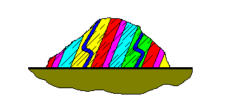
| When rocks fold, the layers slip over each other, and thin beds are sometimes crinkled into so-called minor folds. Note that the folds are Z-shaped on one side of the fold and S-shaped on the other. A geologist can tell that she's crossed the axial plane of a fold by observing that the minor folds change from S- to Z-shaped (or vice versa). | 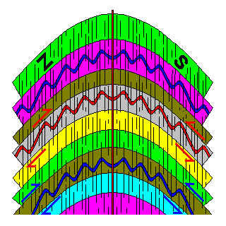 |
How Geologists Use These Clues
 | Here's an outcrop that might be seen in the field. The beds are dipping steeply to the left, hinting perhaps that the beds are on the flanks of an anticline somewhere off to the right. However, the foliation also dips to the left, and the minor folds are inconsistent with an anticline off to the right. |
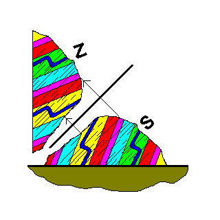 | Mentally, we picture the axial plane of the fold as parallel to the foliation. The other side of the fold is roughly a mirror image of the side we can see. We can guess it's a tight anticline with its right side overturned. There must be a syncline to the right of the outcrop. Note that we have no idea how big the fold is. The axial plane could be a meter or a kilometer away. What we are interested in is figuring out what kind of fold it is and how it is oriented. |
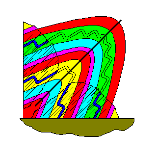 | We can mentally fill out the sketch to get an idea of the shape of the fold. Note that we still have no idea how big the fold is, but we know it's an anticline and have some idea of its shape and orientation. How do we know the axial plane is on this side of the outcrop? It doesn't matter. If we put the axial plane on the other side of the outcrop we would conclude the fold was a syncline, and there is an anticline to the left. We end up with the same results either way. |
The importance of foliation and minor folds is that small structures can provide clues to much larger structures.
Epeirogeny
Epeirogeny is gentle uplift or subsidence of the crust, sometimes by kilometers, but with little igneous activity, faulting, metamorphism, or intense deformation. The mechanisms of epeirogeny are not well understood. Epeirogenic regions are characterized by domes, arches, and basins. The Great Lakes region is one of the best illustrations of epeirogeny anywhere.
Basins and Uplifts in the Midwest
| Legend Cretaceous (Gray) Jurassic (Blue-Gray, Michigan) Permian (Dark Blue) Pennsylvanian (Violet) Mississippian (Blue) Devonian (Light Blue) Silurian (Light Green) Ordovician (Brown) Cambrian (Yellow) Precambrian (Pink) Units within the Great Lakes are lighter shades. | 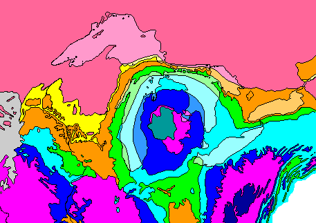 |
| The map above shows the geology of the Great Lakes region. Note that the pattern around Michigan is like a bulls-eye, with younger rocks in the center. Thus, we find Silurian rocks in eastern Wisconsin and Ontario, but they are buried beneath younger rocks in Michigan and are below the surface. Thus the rocks sag downward under Michigan. The structure is like a syncline, but much more broad and gentle, and it's more or less equidimensional. We call such a structure a basin. In Wisconsin, we find old rocks in the center becoming younger as we move away. We'd have to drill downward to find Precambrian rocks in LaCrosse or Green Bay, but they are on the surface in Wausau. Hence the rocks in Wisconsin arch upward, like an anticline but again much more broad and gentle. If this structure were closed on all sides we would call it a dome, but since it's open at each end we refer to it as an arch Note also how the Great Lakes correlate with the rock units. Lake Michigan, the main portion of Lake Huron, and Lake Erie are mostly underlain by Devonian rocks, mostly shales, which were easily excavated by the glaciers. The Green Bay lowland and Green Bay itself were scoured out of soft Ordovician shales (the Maquoketa Formation). So were the channels between the islands in Lake Huron and the mainland, Georgian Bay, the lowland across southern Ontario, and Lake Ontario. Four of the Great Lakes have their shapes and locations determined by structures in the Paleozoic rocks (and Lake Superior is excavated out of relatively soft Precambrian sedimentary rocks as well). The outer edge of the Silurian rocks forms the Niagara Escarpment, which wraps around the north side of the Michigan Basin. It runs along Lake Winnebago and Green Bay, into Michigan, across the Lake Huron islands, down the Bruce Peninsula, across Ontario, and into New York. The Bruce Peninsula, the peninsula in Ontario that separates Lake Huron from Georgian Bay, is a geological and ecological twin of the Door Peninsula, but less developed. | |
| Legend Cretaceous (Gray) Jurassic (Blue-Gray, Michigan) Permian (Dark Blue) Pennsylvanian (Violet) Mississippian (Blue) Devonian (Light Blue) Silurian (Light Green) Ordovician (Brown) Cambrian (Yellow) Precambrian (Red) Units within the Great Lakes are horizontally ruled. | 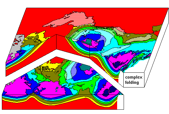 |
| The diagram above gives a three-dimensional view of the structure of the rocks. The vertical scale is very much exaggerated. Precambrian rocks are exposed in Michigan and Ontario, and are 5 km beneath the surface in the center of the Michigan Basin. We know that because a consortium of oil companies and universities drilled a well there in the 1970's. Thus the Michigan Basin is 500 km across but only 5 km deep. At the scale of this drawing, the true depth of the Michigan Basin would be about one screen pixel deep. No attempt has been made to show the complex folding in the Appalachians. Note that all units are not present everywhere. Cambrian rocks are absent north and east of the Michigan Basin, and Silurian rocks are absent in the southwestern part of the map area. Layers do not extend forever; they may be absent because they were eroded away or because they were never deposited in certain areas. Basins are not just empty holes filled by sediments. Everywhere the rocks in this region show evidence of being deposited in shallow water (100 meters deep at most). The sediments accumulate because the crust is subsiding. Note how in Michigan sediments accumulated from the Cambrian through the Pennsylvanian, then stopped. Later on, in the Jurassic, there was a little more subsidence, allowing a little more deposition to take place. It's fairly common for sedimentary basins to resume activity after long periods of inactivity, and it seems to correlate with major periods of mountain-building, but the exact process is still not well understood. | |
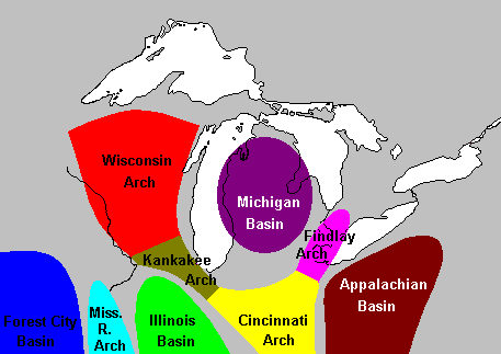 | |
| The major uplifts and basins in the Great Lakes region. These structures actually grade smoothly into one another; we can think of the Silurian rocks of Wisconsin as either the eastern edge of the Wisconsin Arch or the western edge of the Michigan Basin. |
Access Physical Geology Course Notes Index
Access Crustal Movements Notes Index
Return to Professor Dutch's Home Page
Created 25 November 1998, Last Update 31 May 2020