Lake Oshkosh Drainage (12 Ka)
Steven Dutch, Professor Emeritus, Natural and Applied Sciences, University of Wisconsin - Green Bay
Start Series
Next (Later)
Previous (Earlier)
View Text
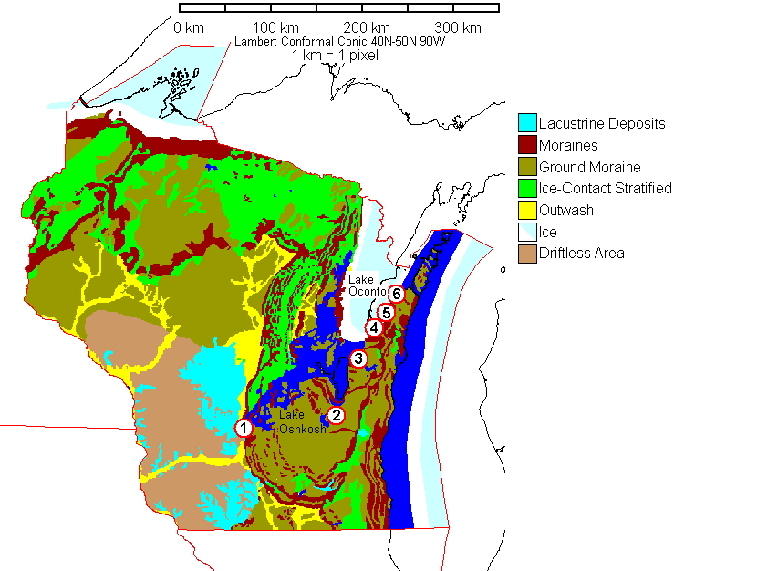
The map shows the ice configuration roughly 12,000 years ago. Ice has mostly retreated from Wisconsin except for the shoreline regions of Lake Superior, Lake Michigan and Green Bay. With ice still blocking Green Bay, water ponded against the ice until it found outlets, creating a large lake called Glacial Lake Oshkosh. One arm of the lake backed up northward behind the recessional moraines and is termed Glacial Lake Oconto.
Possible outlets of Lake Oshkosh are numbered in red:
- 1. To the Wisconsin River near Portage
- 2. Via Horicon Marsh (debatable, and brief at best)
- 3. Manitowoc River near Brillion
- 4. Bellevue Outlet near Green Bay
- 5. Dyckesville Outlet
- 6. Ahnapee River
The next outlet north of the Ahnapee River is Sturgeon Bay, at which point Lake Oshkosh would probably have ceased to exist.
Outlet 1 is to the Wisconsin River at Portage. Well data show convincingly that the pre-Pleistocene drainage in eastern Wisconsin was via the Wolf and upper Fox Rivers to the Wisconsin River. Pleistocene ice scour created the Green Bay lowland, allowing the upper Fox drainage to reverse. The present drainage divide at Portage is negligible: a low sandy ridge barely two meters high. A canal was cut across it in the 19th century to connect Lake Michigan to the Mississippi. It failed, not because the canal was hard to cut (it wasn't) but because the upper Fox River is too shallow and winding to be navigable. With such a minor barrier, why didn't the Fox River simply re-establish its old course?
The probable answer is that the drainage wasn't into the Wisconsin River of the present, but into a short-lived glacial lake south of the Baraboo Range called Glacial Lake Merrimac. Lake Merrimac was dammed by a moraine, and by the time the river had cut through the moraine, Lake Oshkosh had begun draining through other outlets. Any way you look at it, the failure to re-establish the old Fox River drainage was a near miss.
The map shows Lakes Oshkosh and Oconto as coinciding with the mapped extent of lake deposits. However, the actual sequence of events was probably much more complicated. My computer modelling of glacial isostasy in Wisconsin suggests that northeast Wisconsin was tilted downward by at least 100 meters. That amount of tilting would mean that water was ponded against the ice almost everywhere along the ice front. Water would have reached the top of the Niagara Escarpment in many places, and each new outlet would have drained most of the previously-existing lake. Thus, the area traditionally mapped as Glacial Lake Oshkosh may never have been entirely flooded at the same time. Also, if Lake Oshkosh was fully drained when the ice retreated past Sturgeon Bay, what carved the numerous valleys across northern Door County?
Return to Geology of Wisconsin Index
Return to Professor Dutch's Home Page
Created 25 June 1999, Last Update 11 January 2020