The Niagara Escarpment
Steven Dutch University of wisconsin - Green Bay
What is the Niagara Escarpment?
The Niagara Escarpment is the edge of a thick series of dolomite layers of Silurian age. The rocks are resistant to erosion and stand up in relief as a prominent line of bluffs. On the map below, Precambrian and Cambrian rocks are shown in brown, Ordovician rocks in yellow, Silurian rocks in purple, Devonian rocks in light green and younger rocks in dark green. The Niagara Escarpment is shown in red. South of Lake Winnebago (LW) the escarpment is often concealed by glacial deposits, as it also is in upper Michigan. The term "Niagara Escarpment" is sometimes used in other places where the edge of the Silurian rocks form bluffs, especially in Iowa.
The Niagara Escarpment is a landform called a cuesta, where a gently-sloping layer of rock forms a ridge. One side of the ridge has a gentle slope, a so-called dip slope that is essentially the surface of the rock layer. The other side is a steep bluff. The Niagara Escarpment owes its prominence to both the resistance of the Silurian dolomite layers and the relative softness of the Ordovician and Devonian rocks on either side. On the map below, note that the main basins of all the Great Lakes except Superior are defined by belts of soft Devonian rocks. Also, the Ordovician rocks have also been eroded away to create lake basins or lowlands, notably Lake Winnebago (LW), Green Bay (GB), and Georgian Bay in Lake Huron. The Silurian rocks stand up as a ridge that forms Door County (DC), the Garden Peninsula (GP), part of Manitoulin Island (MI) and the Bruce Peninsula (BP). The Escarpment swings southeast across Ontario and into New York, where it is cut by Niagara Falls

The diagram below shows the escarpment in three dimensions, looking southeast. An imaginary trench has been dug across Michigan, showing the structure of the underlying rocks. The rocks sag downward beneath Michigan, a structure called the Michigan Basin. The Silurian rocks dip gently in toward Michigan, and their outer edge forms the Niagara Escarpment.

Lake Winnebago and the Green Bay Lowland
| In this view looking north along the escarpment, we see the partially submerged cuesta of Silurian rocks (yellow). The soft underlying Maquoketa Formation (blue-gray) has been largely scraped away by glaciation. The resistant Sinnipee Group dolomites (green) are partially flooded by Lake Winnebago and Green Bay. |
|
|

 |
In the geologic map at left, Devonian rocks are blue, Silurian yellow and Ordovician rocks are brown and green. We can see that south of Fond du Lac the Silurian escarpment is deeply embayed and trends nearly north-south. North of Fond du Lac, the escarpment is much smoother and trends NNE, and the same is true of the underlying Ordovician rocks as well. |
Silurian Outliers
 |
One of the best kept secrets in the Midwest is the Great River Road in northeast Iowa, which runs along the crest of Silurian outliers and offers sweeping views. Here the Mississippi River is visible in the distance and Wisconsin beyond. |
 |
Blue Mound in SW wisconsin is capped by Silurian rocks, which are mostly chert instead of dolomite. The mineralizing fluids that created the lead-zinc deposits have to have exited somewhere. Why not here? |
 |
View from Blue Mound. |
Lake Winnebago and Escarpment South Of Green Bay
 |
Lake Winnebago is bordered on the east by the Niagara Escarpment. The city of Fond du Lac is appropriately at the bottom of the lake, since that's what "Fond du Lac" means in French. |
 |
Central Lake Winnebago |
 |
The northern end of Lake Winnebago is dammed by a moraine. |
 |
The dammed northern end of the lake. |
 |
This quarry at a location called Scray Hill near Green Bay shows a great thickness of water-deposited sediment, but on the skyline behind the trees, bedrock outcrops are visible. The Escarpment here must be very steep to be that close to the excavation and not crop out. It seems evident that there was a lot of water flowing along the Escarpment here, probably hemmed in by the Escarpment to the east and the Green Bay glacial lobe to the west. |
 |
Early morning view looking south along the Niagara Escarpment near Green Bay. Note the large quarry just below left center. Above it in the distance is a break in the escarpment. The origin of this feature is unclear. Two possibilities are a landslide scar or a valley filled in with glacial debris. |
The Door Peninsula
|
|
View from the escarpment looking west across Green Bay. The lowland is Maquoketa Shale mantled by glacial sediment. |
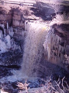 |
Wequiock Falls, northeast of Green Bay. Although the Niagara Escarpment is a line of prominent bluffs, it has few waterfalls. The Silurian rocks form a dip slope toward Lake Michigan so the crest of the Escarpment is a drainage divide in most places. Here, though, a small moraine to the east diverted this stream over the Escarpment. It's about the same age as Niagara Falls and has retreated about 200 meters, in contrast to the 11 kilometers of Niagara. |
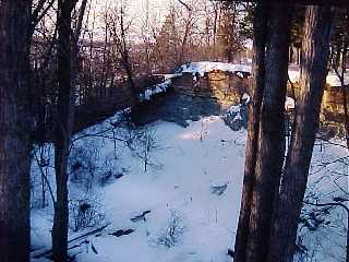 |
Looking west from Wequiock Falls to the mouth of the gorge. The Silurian rocks are buff and the Maquoketa Formation is blue-gray. |
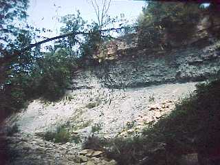 |
Near the end of the gorge. A few meters of resistant buff dolomite form a resistant lip that protects the underlying bluish gray Maquoketa Shales from erosion and maintains the sharp edge of the Falls. The formations are a bit different but this is the same process that maintains the shape of Niagara Falls (and many others). |
 |
View from the Escarpment near Dyckesville, north of Green Bay |
 |
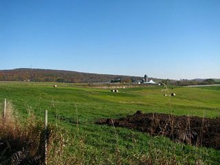
Right place at the right time. I had chartered a light plane to do some aerial photography but bad weather was closing in. So I had the pilot fly up the Escarpment a bit before returning and caught this field with exactly the right amount of snow on it. Probably there is enough water in the soil over the joints to melt the light snow. The Escarpment is so straight in northeast wisconsin that one immediately thinks of joint control but the bedrock face of the escarpment is not a joint surface. Here, the tree line at the bottom marks the Escarpment and a number of very straight and long joints parallel to it are visible. |
 |
The Escarpment north of Sturgeon Bay. A sharp former shoreline is visible, cut during a high stand of Lake Michigan |
 |
Looking north along the Escarpment. The headlands and embayments mark valleys across the peninsula, cut by glacial meltwater and probable pre-glacial erosion. |

The Niagara Escarpment in Michigan
 |
 |
 |
Above: views of the Garden Peninsula looking southeast. Left: The Escarpment in the Upper Peninsula is mostly drift-mantled and subdued. |
 |
The town of Fayette is on the Garden Peninsula and was an iron-smelting town. The ore did not come, as one might suspect, from the Neda Formation, which was mined in wisconsin. Instead it was mined from the Precambrian ores around Iron Mountain and shipped across to Fayette for smelting before being shipped to its destination. Fayette is now a State Park. |
 |
An iron smelting furnace. |
 |
Left and below: Ruins of the smelters. |
 |
 |
 |
View across the bay to the Niagara Escarpment |
The Niagara Escarpment in Ontario
 |
Northern tip of the Bruce Peninsula, Ontario |
 |
The Escarpment approaching Hamilton, Ontario |
 |
The Escarpment approaching Hamilton, Ontario |
Niagara Falls
 |
Well, sometimes ya just get lucky and on a flight to Boston I got a perfect view of Niagara Falls (contrast boosted). American Falls is just below center, Canadian or Horseshoe Falls to its lower left. |
 |
The Falls retreat by undermining the resistant rocks at the lip of the Falls. The lip retreats at about a meter a year, so 1000 years ago the falls probably looked like this. The Niagara Escarpment is kilometers north of here, out of the picture. |
 |
By about 800 years ago, the Falls were about to split around Goat Island. 90% of the water goes around the Canadian side so those falls retreat much faster. |
 |
By about 500 years ago the Canadian Fall is distinct. |
 |
By about the War of 1812 the Falls looked like this. In retaliation for us burning York (now Toronto) the British burned Washington. All anyone can say is, where are they now that we really need them? |
 |
In a few centuries the Falls may look like this. |
 |
Eventually the Canadian Falls will clear Goat Island. |
 |
After the Canadian Falls clear Goat Island, the American Falls channel will be diverted. |
 |
Canadian or Horseshoe Falls. The water is a bit over a meter deep going over the edge. The faster flow in the center of the channel causes faster erosion there. |
 |
The American Falls. Its discharge is much less and it retreats very slowly. Also rubble accumulates at the base. There is a deep plunge pool at the base of the Canadian Falls, making it possible for people to go over the falls in a barrel and survive. Going over the American Falls is not recommended. |
 |
Left: View of both Falls Below: Niagara Gorge |
 |
 |
 |
Left: Canadian Falls viewed from the observation tower. Below: Left: American Falls Below Right, View down the gorge |
 |
 |
Erie Canal
 |
The Erie Canal connected the Hudson River with Lake Ontario and it had to climb the Niagara Escarpment someplace. That was Lockport, New York. |
 |
Looking east (down) along the canal. At first there was a staircase of five locks here. Now there are two. Below: looking west along the canal. |
 |
 |
 |
 |
 |
 |
| Above: Views of the lock gate. | Below: Lockport Dolomite |
 |
 |
 |
A replica of a canal boat. |
Return to Geology of wisconsin Index
Return to Professor Dutch's Home Page
Created 18 June 1999, Last Update 06 February 2022