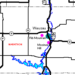
Rib Mountain
Steven Dutch, Professor Emeritus, Natural and Applied Sciences, University of Wisconsin - Green Bay
 |
 |

Distant Views
 |
One of the most attractive views is from the east where State Highway 29 crosses the Wisconsin River. |
 |
Somewhat more leisurely (and less risky) photography is possible from a city park just north of Highway 29 in Rothschild.
Like most people, I pronounced the name of this town "Roth's child." Then my German brain kicked in and I realized the name originated as "Roth Schild" - "Red Shield." |
 |
From the west, Rib Mountain is visible a surprisingly short distance. The curve of the land surface of the Central Upland hides the mountain west of Marathon City. The views below were taken from Highway 29 northwest of Rib Mountain.
 |
 |
 |
 |
 |
The summit of Rib Mountain from Mosinee Hill, about 3 miles southeast. |
Below is a panorama taken from Mountain Road, about 1-1/2 miles south of the mountain. The apparent high point is not the true high point, which is slightly right of the highest tower and a bit beyond the skyline. The apparent high point is a spur that juts south about 1/4 mile closer to the camera. The squarish object in the middle of the flat ridge is a microwave relay tower. The road to the top angles left up the south (near) flank of the rightmost hill, through the low saddle, then follows the crest of the ridge.

Views from the Top
These 360-degree panoramas sweep from due west (ridge on the far left) through north, east (direction of the towers) and south. The top view was taken from the lookout tower on April 1, 2001, the bottom view on October 6, 2001.


The two views were scaled to match as closely as possible. So why don't features line up exactly all the way across? First, there are slight differences in vantage point between the frames used to make up the panorama. More important, the scale of each frame varies between the center and the edge (an inevitable result of projecting onto a flat surface). Slight differences in framing the photos and in matching frames in the two panoramas causes features to be shifted a little between the two scenes.
Baraboo Interval Quartzite
 |
|
 |
Rib Mountain was long thought to be the highest point in Wisconsin before it was displaced by Timm's Hill. The top of this quartzite knob is the highest point, as the sign attests. |
 |
Typical appearance of the quartzite in outcrop |
 |
The quartzite is pure, massive, and mostly featureless. |
 |
Bedding is inconspicuous, but this outcrop reveals some. The beds are a few centimeters thick. |
Sad Commentary
 |
Rib Mountain State Park
The summit of this rock is the highest known point in the state -1940 feet above sea level This land, forty acres in area, was presented to the commonwealth on January 26, 1923 by the estate of Jacob Gensman. The park was enlarged to 160 acres by the Kiwanis Club of Wausau. |
The bottom paragraph reads:
This area was originally sandy beach swept by the ocean. The sand was finally hardened to quartzite rock and by slow upheaval turned on edge and raised to its present height.
Someone chiseled off the word "slow," but parts of the letters are still faintly visible. This is all anyone needs to know about the integrity of believers in a young earth.
Return to Geology of Wisconsin Index
Return to Geologic Localities Index
Return to Professor Dutch's Home Page
Created 5 June 2001, Last Update 19 Jan 2020