Leaverites - Features in Sedimentary Rocks
Steven Dutch, Professor Emeritus, Natural and Applied Sciences, University of Wisconsin - Green Bay
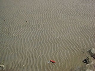
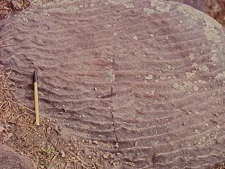
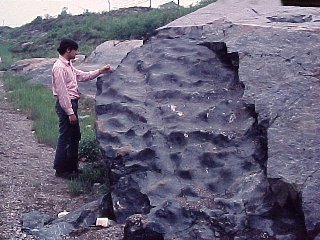
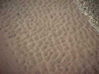
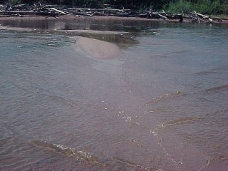
Ripple Marks
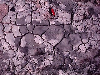
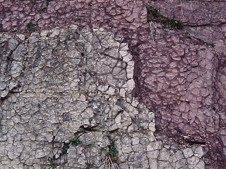
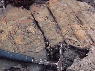
Mud Cracks
polygonal patterns resulting from the sediment drying and shrinking before it was buried. These often have rims of whatever filled the cracks.
 |
Mud cracks on the bottom of a modern puddle. |
| Mud cracks in the dolomite at Maribel Caves, Wisconsin, evidence that the limy mud that formed these rocks occasionally dried out. The rocks probably formed in a tidal flat environment. |
 |
 |
Mud cracks in Cambrian rocks in southwestern Virginia. Even the curls of the flaking mud are preserved. We are looking at the top of the beds here. |
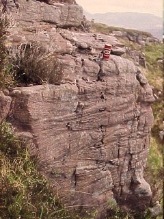
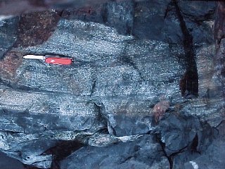
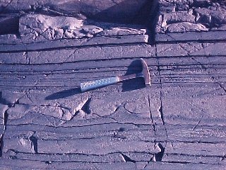
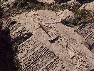
Cross-Beds
Usually seen on surfaces that break through the rock layers. Within the layer are smaller slanting layers caused by shifting patterns of erosion and deposition. Wind and water action can both produce cross-bedding.
 |
These large cross beds probably formed in an offshore sandbar |
| Small cross-beds like these, from Scotland, are often called "festoon" crossbeds. They formed from rapid cutting and infilling of small channels, probably in an alluvial fan. |
 |
 |
These large and fairly uniform crossbeds from southern Illinois probably were made by a small stream delta during a marine invasion. Shale interbeds represent quiet intervals when the delta was somewhere else, then, later on the delta returned to this location when the water was deeper. Three separate episodes can be seen. In each case the delta built from right to left. |
| Cross-beds are rarely seen from above, but when they are they look like this. Small channels were cut and then filled in from right to left. |
 |
 |
Huge cross beds like these are usually dune sands. You can't see from the picture alone that they even are cross beds. Only by noting that all the rock layers around are horizontal can you tell. |
| This rock contains several sets of cross beds nicely outlined by the green mineral glauconite. |
 |
Graded Bedding
 |
Layers where coarse material grades into finer material toward the top, usually caused by fast-moving water that slows down. Floods and submarine landslides are common causes. |
Salt Crystal Casts
| Relatively rare. These are square or angular impressions left by salt or gypsum crystals as sediment dried out. The small square lumps on the rock at right are salt crystal casts.
|
 |
| A closer view. |
 |
Reduction Spots
| Reduction spots are circular (actually spherical) pale spots in reddish sedimentary rocks. Something at the center causes the iron in the surrounding rock to be less oxidized (or reduced). The culprit can be a fossil or small mineral fragment. |
 |
|
 |
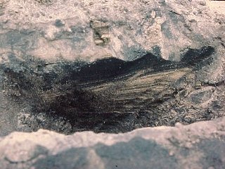
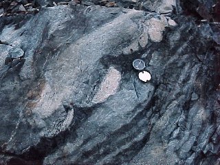
Omars
 |
Omar is short for Omarolluk. The Omarolluk Formation occurs in the Belcher Islands of Hudson's Bay. Round calcareous concretions occur in a fine-grained metamorphosed siltstone. When they weather out, they leave hemispherical holes. These rocks are only known to occur in a small area in Hudson's Bay but the glaciers spread them across central Canada and into the northern U.S. |
 |
 |
 |
Here's a very large concretion that hasn't completely weathered out yet. |
Wave Action
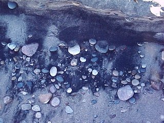 |
This looks like horrible pollution but is actually perfectly natural. On the Lake Michigan shoreline, wave action washes away light minerals, leaving only black magnetite sand at the high-water mark. |
 |
When wave conditions are right, layers of almost pure magnetite can form, like those seen in this shallow trench. |
Load Casts
 |
When sediment is deposited faster than it can compact, it can sag downward into still-mushy layers below, and mud can squirt upward. Sags like these are called load casts. These are from the Antarctic Peninsula. Note that the coarse bed is graded and the largest grains fill the bottoms of the sags. |
Flame Structure
 |
Sometimes mushy sediment will find only a few weak spots, and produce isolated structures like this, called a flame structure. This one is near Sudbury, Ontario.
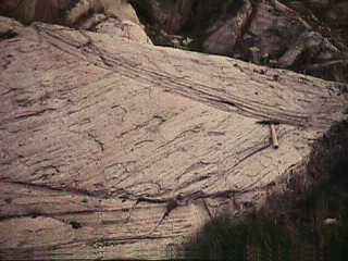
The extremely smooth, flat surface is due to glacial action.
|
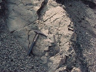
Sandstone Dike
 |
This looks like a dike, but close inspection shows that the rock is sandstone. A sandstone dike? Yes, that's exactly what it's called. This one is north of Lake Huron in Ontario. Sandstone dikes form when sediment is partially consolidated but under high pressure. If a water-laden layer can find a weak spot in the overlying layers, it squirts upward. Earthquakes are a common trigger. Note how large pieces concentrated in the center where flow was fastest. |
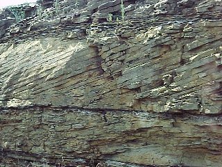
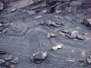
Soft-Sediment Deformation
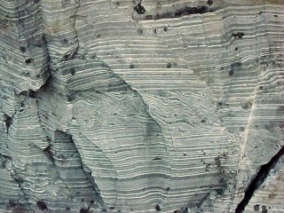 |
The very uniform layers here are varves, alternating thick and thin layers formed in a glacial lake. The contorted zone running across the center is probably due to glacial ice shoving the upper layers of sediment over the lower layers. Deformation that occurs while sediments are partly or wholly unconsolidated is called Soft-Sediment Deformation |
 |
|
 |
Sometimes a stack of layers will slip over a weak layer beneath, rumpling like a carpet. |
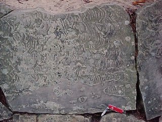
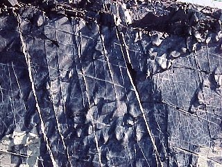
Flute Casts
 |
Submarine landslides are common on the edge of the continental shelf. The landslide flows scour flutes in the underlying sediment, then come to rest as graded beds of sand and silt that fill in the sculpted bottom. We are looking at the underside of a submarine landslide deposit in New Brunswick. |
 |
Looking at the underside of another submarine landslide deposit in New Brunswick. The flutes scoured by submarine landslides tend to be steep on the upstream end and gently-tapered on the downstream end, making it easy to tell which way they moved. These structures are hard to observe directly forming in nature but quite easy to duplicate in the laboratory. |
Return to Mineralogy-Petrology Index
Return to Thin-Section Index
Return to Crystals and Light Index
Return to Crystal Structures Index
Return to Mineral Identification Tables
Return to Professor Dutch's Home Page
Created 15 October 2009, Last Update