Non-Impact Sites
Steven Dutch, Professor Emeritus, Natural and Applied Sciences, University of Wisconsin - Green Bay
Not everything that makes an arc on a map or air photo is an impact crater. Impact basins big enough to see easily on a map would result in huge volumes of impact melts and widespread distinctive deformation of the rocks. Here are a few old favorites that have been repeatedly put forth as candidates but do not show any geological evidence for impact origin.

The arc on the east side of Hudson's Bay is astonishingly circular, but it is not an impact site. However, two genuine impact sites are visible on this map (circled in red). The pair of lakes just east of the arc are the Clearwater Lakes, a rare double impact site. In the far southeast of the map area is the Manicouagan impact.

The coast of New Brunswick forms a nice arc, with Prince Edward Island concentric to it. This has also been proposed as the rim of an impact basin. Interestingly, the Manicouagan impact structure is visible in the far northwest of this map area as well. This portion of New Brunswick consists of Pennsylvanian rocks while Prince Edward Island is mostly later Permian rocks overlying the Pennsylvanian. All the rocks are nearly horizontal. The arc appears to be the edge of a very gentle sag in the rocks, something like the pattern around the Michigan Basin, below.
 |
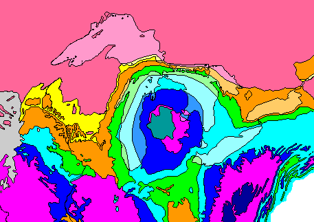
The arc formed by Lakes Michigan and Huron outlines a structure called the Michigan Basin. Belts of soft shale of Devonian age were scoured away by the glaciers to excavate the main lake basins. Layers of more resistant Silurian dolomite form a chain of islands and peninsulas. Softer Ordovician shales beneath the Silurian rocks were excavated to form Green Bay, the channel north of Manitoulin Island, and Georgian Bay. |
The geologic map below shows how the lakes relate to rock units. Devonian rocks are light blue, Silurian green, and Ordovician orange. Rocks beneath thelake are shown in lighter tones. Note that Lakes Erie and Ontario are also located within the softer rocks.

One of the more ambitious suggestions around is that the arc of great lakes of North America might mark the rim of an impact basin. Actually, the lakes mark the zone of deepest excavation by the Laurentide Ice Sheet, which is typically about 300 kilometers in from the ice margin. Within the arc are innumerable lakes where the glaciers scoured down to crystalline bedrock. Hudson's Bay is centered in the arc because the ice was thickest there and the crust has not yet fully rebounded from the load.

Everyone who looks at satellite images of Wisconsin is drawn to this feature. The Mississippi River slants across lower left, while the Chippewa and Black Rivers outline the western and eastern sides of the ring, respectively. The color boundary comes from joining two photos taken at different seasons. LaCrosse is at the extreme bottom of the picture and Eau Claire just west of the top of the ring. The large lake at top is Lake Wissota, the lake Leonardo di Caprio fell into in Titanic even though it wasn't created until some years after the Titanic sank.
I have criss-crossed this feature looking for any geologic explanation for the ring. The rocks within and around the ring are flat-lying undisturbed Cambrian sandstones with no evidence of any unusual fracturing or other distinctive features.
Round Holes
Just because something is a round hole doesn't make it a crater. If some process enlarges holes and acts at the same rate in all directions, it will create a circular hole even if the original hole was irregular. Examples:
- Sinkholes. They start out as cavern collapses but enlarge by weathering and dissolution.
- Kettle ponds start out as depressions left when masses of stagnant ice melt. Collapse of the kettle walls and erosion enlarge them and make them more circular.
- Thermokarst. Melting of permafrost creates depressions which fill with water. Additional melting enlarges and circularizes them.
- The Carolina "bays" are elliptical depressions on the Atlantic Coastal Plain. Their origin is unclear but they are certainly not due to impact since they lack all of the diagnostic features of impact sites. The most widely accepted hypothesis is they are due to chemical weathering of the underlying bedrock.
Access Other Pages on Planets
Access Course Notes on Planetary Geology
Return to Professor Dutch's Home Page
Created 18 April 2003, Last Update 11 January 2020