History of Global Plate Motions
Steven Dutch, Professor Emeritus, Natural and Applied Sciences, University of Wisconsin - Green BayDisplay Options
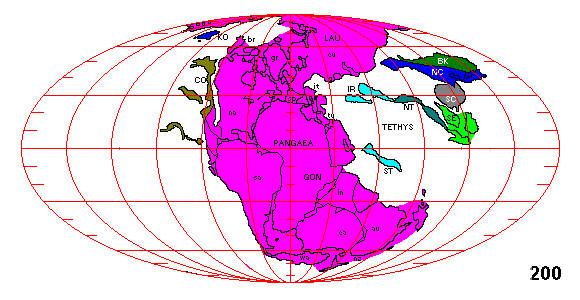
You can simply scroll down through the maps, reading the text for each. You can also flip from map to map by clicking on the Later and Earlier prompts. To view a map of an earlier time, select "Earlier", to view a map of a later time, select "Later." Labels on the maps in capitals denote separate plates; lower case denotes subregions for geographic reference. Present coastlines are shown for geographic reference only. Refer to the bottom of the page for a listing of symbols and their meanings.
There is a similar set of maps using 1979 data. It's revealing to compare the two to see how our understanding of plate configurations has changed with 15 years of better data. In general, the later maps include a lot more small terranes, a great deal more accurate information about the assembly of Asia, and extend further back in time to the late Precambrian. By 1994 it was possible to understand at least roughly the assembly of the plates that formed Gondwanaland.

Earlier
Breakup of Pangaea

Later=======Earlier

Later=======Earlier

Later=======Earlier
Later=======Earlier
Assembly of Pangaea

Later=======Earlier

Later=======Earlier

Later=======Earlier

Later=======Earlier

Later=======Earlier

Later=======Earlier

Later=======Earlier
Assembly of Gondwanaland

Later=======Earlier

Later=======Earlier

Later=======Earlier

Later=======Earlier

Later=======This is as far back as we can go now.
Rodinia

The sequence of maps above is drawn with the land masses roughly centered. Unfortunately, as Gondwanaland slides down over the south pole, there is no way to portray it without either seriously distorting it or abruptly rotating the globe. The last map, in particular, needs to be viewed from the other side of the globe. The map shown here is a 750 m.y. reconstruction redrawn from the 750 m.y. map immediately preceding it, but viewed from the other side of the globe. We can see that once again the continents are assembled into a supercontinent, only this time North America is in the middle instead of Africa. This earlier supercontinent has been given the name Rodinia.
Index of Plates and Symbols
From Pangaea to the Present
| Af - - Africa Ar - - Arabia Au - - Australia Bk - - Baikal Block Br - - Brooks Range Co - - Cordilleran Accreted Terranes. Shown schematically west of North America. Exact configuration and location unknown. Ea - - East Antarctica Eu - - Eurasia Gr - - Greenland In - - India Ir - - Iran It - - Italy, including numerous small plates that now make up the Balkans. Ko - - Kolyma Block, present northeastern Siberia |
Ma - - Madagascar Na - - North America Nc - - North China Nt - - Northern Terranes. Shown schematically. Accrete to Eurasia. Nz - - New Zealand Sa - - South America Sb - - Spitzbergen Sc - - Scotland Sc - - South China Se - - Southeast Asia Sp - - Spain St - - Southern Terranes. Shown schematically. Accrete to Eurasia. Tu - - Turkey Wa - - West Antarctica Xi - - Xinjiang |
From the Cambrian to Pangaea
| Af - - Africa Ar - - Arabia Au - - Australia Av - - Avalonia, consisting of parts of the British Isles (en), Newfoundland (nf), Nova Scotia (ns) and Maine (me). Ba - - Baltica. Core of ancestral Europe. Bk - - Baikal Block Br - - Brooks Range Co - - Cordilleran Accreted Terranes Ea - - East Antarctica Eg - - East Gondwanaland En - - England En - - Eurasia Fl - - Florida and SE USA Fr - - France Gon - - Gondwanaland Gr - - Greenland In - - India Ir - - Iran It - - Italy, including numerous small plates that now make up the Balkans. |
Ko - - Kolyma Block, present northeastern Siberia Lau - - Laurasia La - - Laurentia. Core of ancestral North America. Ma - - Madagascar. Mostly not labelled. Nc - - North China Nt - - Northern Terranes. Mostly not labelled. Nz - - New Zealand Sa - - South America Sb - - Siberian Craton Sb - - Spitzbergen. Attached fo Laurentia. Sc - - Scotland. Attached fo Laurentia. Sc - - South China Se - - Southeast Asia Sp - - Spain St - - Southern Terranes. Mostly not labelled. Tu - - Turkey Wa - - West Antarctica Wg - - West Gondwanaland |
Precambrian Plates and Symbols
| Ar - - Arabia Au - - Australia Bk - - Baikal Block Br - - Brooks Range Co - - Cordilleran Accreted Terranes Ea - - East Antarctica Eg - - East Gondwanaland Fl - - Florida and SE USA Gon - - Gondwanaland Gr - - Greenland In - - India Ir - - Iran It - - Italy, including numerous small plates that now make up the Balkans. Ko - - Kolyma Block, present northeastern Siberia La - - Laurentia Mz - - Mozambique Belt: eastern and southern Africa |
Nc - - North China Ni - - Niger Block: eastern Brazil plus north-central Africa. Rp - - Rio De La Plata Craton: northern Argentina. Sa - - South America: Guyana Craton, consisting of northern and western Brazil and adjacent areas. Sb - - Siberian Craton Sb - - Spitzbergen. Part of Laurentia Sc - - Scotland. Part of Laurentia Sc - - South China Se - - Southeast Asia Sp - - Spain Tu - - Turkey Wa - - Western Arabia: Egypt and Arabia adjacent to the Red Sea. Waf - - West African Craton Wg - - West Gondwanaland |
References
Map data is derived from Christopher R. Scotese, 1994, Continental Drift, Edition 6, Paleomap Project, University of Texas at Arlington. This is a flip-animation booklet with maps portraying continental positions at 10 m.y. intervals from 750 m.y. ago to the present.
Dalziel, Ian, 1995, Earth before Pangaea, Scientific American, v. 272, no. 1, p. 58-63
Return to Plate Tectonics Page
Return to Physical Geology Class Notes Index
Access Crustal Movements Notes Index
Return to Professor Dutch's Home Page
Created 17 December 1998, Last Update 19 January 1999