Orogeny and Rivers in the West
Steven Dutch, Professor Emeritus, Natural and Applied Sciences, University of Wisconsin - Green Bay
Two Mountain Ranges Compared
 |
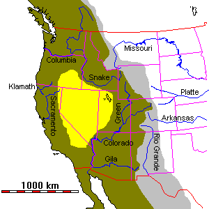 |
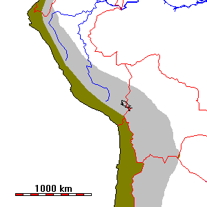
| In the central Andes of Peru and Bolivia, the mountain belt is about 600 km wide at most. The drainage divide between the Pacific watershed (brown) and the Atlantic watershed (gray) is very close to the plate margin. | In the western United States, the mountain belt is well over 1000 km wide and the drainage divide is close to the eastern side of the orogenic belt. There is a large closed interior basin (yellow) created by crustal extension. |
The mountains of western North America are a lot more complex than the Andes for a variety of reasons. The Andes are about as close as one can hope to get to a "theoretical" subduction zone. Terrane accretion in the Andes has been relatively unimportant, whereas half or more of the North American Cordillera has been accreted. Indeed, there is some evidence for tectonic erosion along the Andean subduction zone; South American crust may have been scraped off and carried into the subdution zone (probably to be remelted and added to the igneous arc of the Andes). There are rocks two billion years old near the coast of Peru.
In contrast to the Andes, the Rockies contain numerous block-faulted complexes, especially the ranges of Wyoming like the Wind River, Laramie, and Medicine Bow Ranges. The most widely accepted explanation for why tectonic activity extended so far inland in North America is that the subduction zone that once extended along the entire West Coast had a very flat-dipping slab.
Before the Spreading
Many geologists have argued on the basis of geologic history and topography for great drainage diversions throughout the West. Until recently, these hypotheses, plausible as they may have been, had little chance of confirmation. In recent years, DNA studies on aquatic populations have been used to try to confirm or refute some of these hypotheses.
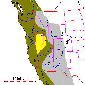 |
The map at left is a reconstruction of the Western U.S. about 30 m.y. ago, before the extension of the Basin and Range Province and the opening of the Gulf of California. The Great Basin has been reduced in width by half and Baja California and California west of the San Andreas Fault have been moved southeast to close the Gulf of California.
This sort of map is called a palinspastic map. A palinspastic map corrects for crustal deformation. Maps of this sort were once much more widely used, but many of them were attempts to reconstruct mountain belts that we now know were actually built of disconnected terranes. In the case of this map, no major terranes have been accreted to the West Coast of North America since the time represented here, so the map is at least approximately correct. |
- The ancestral Missouri River, like all major rivers of the northern Plains, flowed northeast across Hudson's Bay (which was then land). The present drainages are all the result of glacial diversion during the Pleistocene.
- DNA studies suggest a former connection between the Green River and the Mississippi drainage system
- Given the other drainage changes on the map, a connection between the upper Colorado and Mississippi systems seems likely. The Platte River serves nicely as a continuation of the Green and upper Colorado Rivers.
- DNA studies suggest a connection between the upper Snake River and the Humboldt-Lahontan drainage of Nevada, which may well also have continued via the Feather River to the Pacific. The drainage almost certainly was not via present San Francisco Bay, which didn't exist until a few million years ago.
- Other DNA studies suggest a connection between parts of the Snake River and the Klamath River of Oregon.
- The lower Colorado probably drained to the Pacific. Voluminous conglomerate deposits near San Diego, otherwise unexplainable, have long been suggested as a former Colorado River delta.
- DNA studies suggest possible connections of the Gila and Little Colorado Rivers to the Rio Grande.
- The sharp bend in the upper Sacramento River basin suggests a probable former connection to the Klamath River as shown.
The drainage diversions in Canada and Mexico are unknown. The Columbia River certainly did not have the course shown. The present river flows along the boundary between the Columbia Plateau volcanic rocks (about 15 m.y. old) and the Cascade highlands. Does the sharp bend in Canada represent diversion of a former north-flowing system?
If we reconstruct these drainage diversions, the mountain belt of western North America 30 m.y. ago was much narrower and the continental divide a good deal further west. Although still more complex than the Andes, it looks a lot more similar.
Running the clock still further back, to say 50 m.y. ago, we might surmise that the active mountain building was fairly close to the coast, that the uplifts in Colorado and Wyoming were barely beginning, and that the margin of North America looked a great deal like the present Andes.
Return to 296-202 Class Notes Index
Return to Professor Dutch's Home Page
Access Crustal Movements Notes Index
Created 18 May 2000, Last Update 18 May 2000