Construct a Fold Cross-Section Using the Similar Fold Method
Steven Dutch, Professor Emeritus, Natural and Applied Sciences, University of Wisconsin - Green Bay
Similar folds are those where successive beds all have the same shape. They can be generated by drawing the shape of one bed and then shifting it parallel to the axial plane of the fold. The basis of this method is that, if you can somehow estimate the dip of the axial plane, you can use dip data to construct the fold by simply translating data parallel to the axial plane.
In practice this method is not often used. It's rare to find truly similar folds on a large enough scale to make the method practical. Usually, rocks that are ductile enough to fold in similar style will deform inhomogeneously enough to defy any simple extrapolation method. However, this is a very simple method and can be used in conjunction with the arc (Busk) or kink methods to define the range of possible fold shapes that satisfy a given data set.
Example
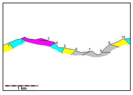 |
In the example at left, dip data are shown. We want to construct a cross-section that satisfies the data.
The stratigraphic units are colored here but will not be colored for most of the remaining diagrams. It is often better not to consider stratigraphy until after the cross-section is drawn. |
 |
We have to estimate the dip of the axial plane to draw similar folds. We can do this in several ways:
1. We may have foliation measurements available 2. We can observe that westerly dips are steeper than easterly, therefore the axial plane is tilted to the east. 3. We can use the arc (Busk) or kink method to estimate the shape of the folds. |
 |
Construct lines midway between dip measurements and parallel to the axial plane.
Assume dip is constant in the zone between each pair of lines Extrapolate dips between adjacent lines as shown. |
 |
Here we extrapolate dip 2 into the dip 1 zone and vice versa. |
 |
Here we extend data from zone 3 into zones 1 and 2, and data from zone 2 into zone 3. |
 |
Here we extend data into zone 4. Since the bed at dip datum point 2 barely misses point 4, we can ignore constructing a line through 4 for the time being. |
 |
Data extrapolated into zone 5. Datum point 5 is bracketed by other extrapolations so we can pass on drawing anything through point 5 for now.
If the need arises we can always go back and extrapolate any bypassed points. |
 |
Data extrapolated into zone 6.
Datum point 6 is stratigraphically lower than anything we have seen so far, so we extrapolate its dip back through all the previous zones. |
 |
Data extrapolated into zone 7.
Datum point 7 is again stratigraphically lower than anything we have seen so far, so we also extrapolate its dip back through all the previous zones. |
 |
Data extrapolated into zone 8.
Datum point 8 is stratigraphically lower than anything we have seen so far, so we extrapolate its dip back through all the previous zones. |
 |
Data extrapolated into zone 9.
Datum point 9 is bracketed by other extrapolations so it is unlikely to tell us anything we don't already know. We can pass on drawing anything through point 9 for now. |
 |
Data extrapolated into zone 10.
Datum point 10 is also bracketed by other extrapolations so it is unlikely to tell us anything we don't already know. We can pass on drawing anything through point 10 for now. |
Tying the Diagram to Reality
It is virtually certain when you draw a cross section using strictly geometric methods that the contacts will not match exactly with their predicted positions. There are many reasons why not:
- The units will not be uniform in thickness
- There are small construction errors
- Dips are not uniform from place to place
- Dip measurements have small errors
- Folds do not have ideal geometrical shapes.
 |
Here we have indicated the stratigraphy. It is virtually certain when you draw a cross section using strictly geometric methods that the contacts will not match exactly with their predicted positions.
On the whole this is not a bad job. The contact through point 1 comes out too low stratigraphically at points 5 and 10, suggesting that we might get a better fit by a slightly steeper dip on the axial plane. Also, we can see we really do need to extrapolate the points we bypassed. |
 |
Here all the construction has been removed and the lines are subdued.
Most of the time you can modify the fold shapes by hand to match the stratigraphy without too much trouble. Modified contacts are in black. Here, tracing the fold shape and shifting it slightly was enough to match both dip and location. |
Effect of Axial Plane Dip
|
An axial surface dipping steeply east fits the data pretty well for a first approximation. Beds are fairly uniform in thickness |
 |
A vertical axial surface fits the stratigraphy a bit better between points 1 and 5, not quite as well between 5 and 10. Bed thickness varies quite a bit more and the folds extend deeper. You'll have to compare the fold prediction with other field data to see if this is a better model or not.
Comparing this and the previous result, we might try a model with a very steep but definite easterly dip. |
 |
A tilt in the wrong direction gives a very poor fit to stratigraphy. |
Return to Course Syllabus
Return to Techniques Manual Index
Return to Professor Dutch's Home Page
Created 18 October 2000, Last Update 20 October 2000