Larch Mountain, Oregon
Steven Dutch, Professor Emeritus, Natural and Applied Sciences,
University of Wisconsin - Green Bay

Larch Mountain is a 4000-foot peak east of Portland, Oregon. The high point, Sherrard Point, is a volcanic neck.

When the weather gods smile (a rarity in the Pacific Northwest) Larch Mountain offers views of five Cascade Range volcanoes.
 |
The drive up Larch Mountain offers nothing in the way of views whatever. |
 |
 |
 |
 |
 |
 |
 |
 |
 |
 |
 |
 |
 |
 |
 |
|
 |
Even at the parking area, the view is hemmed in by trees. |
 |
Glimpses through the trees hint that there is more to come. |
 |
Left: sheet jointing in the rocks at Sherrard Point. Below: looking down from Sherrard Point. |
 |
 |
 |
 |
Mount Rainier
 |
 |
 |
 |
Mount St. Helens
| Mount Saint Helens must have been a magnificent sight from here before it lost its summit in 1980. | Although it was just shy of 10,000 feet in 1980, it now stands at 8365 ft (2550 m). |
 |
 |
 |
 |
 |
 |
 |
 |
 |
 |
 |
 |
 |
 |
 |
 |
Mount Adams
 |
Mount Adams (12276 ft; 3742 m) deserves way more respect than it gets. It's the fourth highest peak in the Cascades (after Rainier, Shasta, and is just barely beaten by Shasta's satellite peak, Shastina) |
 |
 |
 |
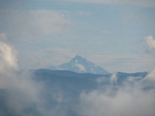
Mount Hood
 |
11239 ft; 3426 m and the highest point in Oregon. |
 |
 |
 |
 |
 |
 |
 |
 |
 |
 |
 |
 |
 |
 |
 |
Mount Jefferson
10,495 feet (3,199 m) and the second highest peak in Oregon. It last erupted about 950 AD.
 |
 |
 |
 |
 |
 |
The Weather Gods Smile
 |
 |
 |
 |
 |
 |
 |
 |
 |
View downstream of the Columbia River |
 |
 |
 |
The heiligenschein, or saint's halo, is a bright reflction opposite the sun. It can be seen on pretty much any rough surface. |
 |
 |
 |
 |
 |
Abouve: Mount Adams in the distance Left: Mount Hood |
 |
Left and below: the Columbia River Gorge. |
 |
 |
 |
 |
 |
 |
 |
 |
 |
 |
 |
 |
 |
 |
 |
 |
 |
 |
 |
 |
 |
 |
Return to Historic Sites Index
Return to Virtual FieldTrips Index
Return to Professor Dutch's Home Page
Created 22 June 2007, Last Update 06 June 2020