Spearfish Canyon, South Dakota
Steven Dutch, Professor Emeritus, Natural and Applied Sciences, Universityof Wisconsin - Green Bay


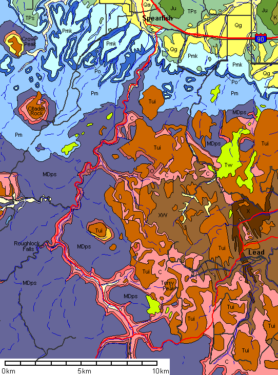 |
Qa: Quaternary Alluvium Qg: Quaternary Gravels Tw: Tertiary White River Group Tui: Tertiary Intrusives K: Cretaceous Ju: Jurassic TPs: Triassic-Permian Spearfish Formation Pmk: Permian Minnekahta Limestone Po: Permian Opeche Shale Pm: Permian-Pennsylvanian Minnelusa Formation MDps: Mississippian-Devonian Paha Sapa Limestone O: Ordovician Whitewood Limestone and Winnepeg Siltstone C: Cambrian Deadwood Sandstone X: Proterozoic Metamorphic Rocks XW: Proterozoic and Archean Metamorphic Rocks |
 |
Ordovician rocks are not present in the southern Black hills but make up much of the roadside section in Spearfish Canyon. |
 |
 |
 |
 |
 |
Bridal Veil Falls
 |
Bridal Veil Falls drops over a cliff in the Precambrian metamorphic rocks. The Precambrian outcrop area is too small to show on the geologic map above. Reddish Deadwood Sandstone is sunlit at left. |
 |
 |
 |
 |
 |
 |
| Above: Deadwood Sandstone (reddish layered rock above) in contact with Precambrian metamorphic rocks (massive rocks at lower right). | Below: Looking north, the distant cliff shows a clear angular unconformity between the Devonian-Mississippian Paha Sapa Limestone and the Cambro-Ordovician section below. |
 |
 |
 |
 |
Roughlock Falls
 |
Roughlock Falls is on a tributary canyon. The name comes from a
wagon road that once ran up the canyon. Wagoneers coming down the steep
grade by the falls used to "rough lock" their wheels - lash
them in place and skid the wagons down the slope. These are cliffs at the entrance to the canyon. |
 |
Cliffs at the canyon mouth from a different vantage point. |
 |
A good but unpaved road leads to the falls. These are views en route. |
 |
 |
 |
|
 |
 |
| Above: Rapids above the falls. | Below: Upper Roughlock Falls |
 |
 |
| Below: Roughlock Falls. In 2004 the trail that closely approached the falls was closed for habitat restoration. | |
 |
 |
 |
 |
 |
 |
 |
 |
 |
 |
 |
 |
 |
 |
 |
 |
 |
 |
 |
 |
Views looking up toward the head of Spearfish Canyon. The upper cliffs are Paha Sapa Limestone |
 |
 |
Aerial View
| Late afternoon view looking north from 30,000 feet. Spearfish Canyon extends up the middle of the picture. The tributary canyon of Roughlock Falls enters Spearfish Canyon from the left at the sharp bend. Terry Peak is the mountain at lower right center just below the two large cleared areas. The cloud plume is smoke from a forest fire. |
 |
References
Geologic map based on:
Strobel, M.L., Jarrell, G.J., Sawyer, J.F., Schleicher, J.R., and Fahrenbach, M.D., 1999; Distribution of hydrogeologic units in the Black hillsarea, South Dakota, U.S. Geological Survey Publication Series and Number: Hydrologic Investigations Atlas HA-743: Map Scale: 1:100,000
Return to Historic Sites Index
Return to Virtual FieldTrips Index
Return to Professor Dutch's Home Page
Created 15 January 2005, Last Update 09 June 2020