Vernal and Nevada Falls
Yosemite National Park, California
Steven Dutch, Professor Emeritus, Natural and Applied Sciences, Universityof Wisconsin - Green Bay
Eastern yosemiteValley. Note how the valley of the Merced River becomes broad and flat-floored upstream from Nevada Falls.

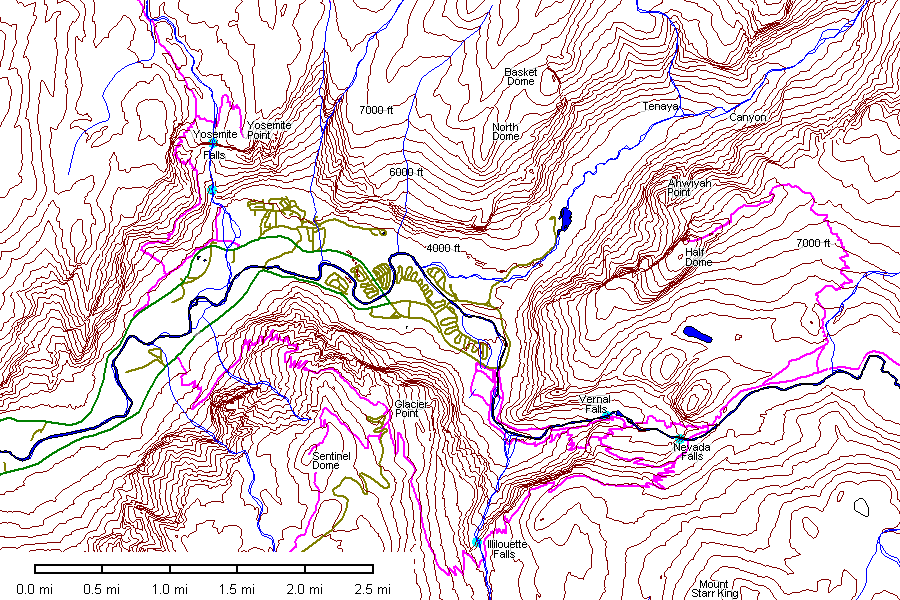
Map of Little yosemiteValley. Possible abandoned valleys are in green. Trails are purple. Note the absence of any significant barrier between the Merced River and the valley immediately north of Nevada Falls (contour interval 40 feet). The heavy contour immediately upstream from Nevada Falls is 6000 feet.
 |
The standard postcard view from Glacier Point with Liberty Cap at
left, Nevada Falls just left of center, and Vernal Falls below and to
its left. The odd ring of vegetation above and right of Nevada Falls appears to be rimming a rockslide. The straight diagonal line to its right is discoloration of the rock along a small rivulet of water. |
 |
Detail of Nevada Falls. Note that the falls bypasses a valley to its left. The vegetation ring is at uppermost right and appears to be enclosing a tract of boulders. |
 |
Detail of Vernal Falls. The falls drops off a sheer joint face, which is very much wider than the present falls. Perhaps the falls during glacial retreat were far more impressive. |
 |
Something to consider before hitting the trails. |
 |
The Merced River as it enters yosemiteValley. |
 |
North Dome on the left, Basket Dome on the right. Below: Glacier Point. |
 |
 |
 |
yosemiteFalls. |
 |
Left and below: the Merced River. |
 |
 |
 |
Illilouette Falls is one of the less-seen falls of yosemite, most often seen from Glacier Point. High country melt water has not yet swollen the falls. |
 |
 |
 |
Glacier Point |
 |
Left and below: the Merced River. |
 |
 |
 |
First glimpse of Vernal Falls. You can follow the river and then ascend near the falls on the Mist Trail ("mist" is a euphemism for soaking wet) or take the higher trail. I still got wet. |
 |
Vernal Falls from downstream. |
 |
Left and below: yosemiteFalls. |
 |
 |
 |
|
 |
Rock face on the north side of the Merced River. |
 |
Grizzly Peak. |
 |
|
 |
South side of Half Dome. |
 |
Mount Broderick on the left, Liberty Cap on the right, with Nevada
Falls. What cut the deep gorge between the two peaks? |
 |
Half Dome and Mount Broderick |
 |
|
 |
Glacier Point at left, yosemiteValley in the distance, and Grizzly Peak at right. |

panorama looking north. Glacier Point is at far left, with yosemiteValley disappearing in the mist. The hump right of yosemiteValley and left of the tree is Grizzly Peak. Half Dome is the highest point on the skyline, with Mount Broderick and Liberty cap to its right and Nevada Falls on the farthest right.
Once you get beyond granite domes, exfoliation and glaciation, yosemite's geomorphic history gets more complex the more you think about it. The Merced River valley upstream from Liberty Cap is broad and flat-floored. How did the valleys that flank Mount Broderick and Liberty Cap get cut, and when? Why does Nevada Falls drop over the ledge instead of flowing down the valley immediately to its north? The river isn't deeply entrenched into the ledge; what's keeping it in its course? Surely an ice dam or winter avalanche could back the river up enough to spill over an inconsequential drainage divide.
 |
Left and below: Half Dome. |
 |
 |
 |
The critters have an arrangement with hikers. |
 |
 |
 |
 |
| Above: Vernal Falls drops over a sheer joint face. | |
 |
Nevada Falls owes its odd bent appearance to the fact that it flows down a steep rock face and hits an inclined joint about halfway down. |
 |
Here we have another waterfall that drops over a cliff when there's
a perfectly good valley right next door.
Below: the trail and Merced River. |
 |
 |
 |
After reflecting on the geomorphology, I really wish I had gone over to Nevada Falls, but the weather was closing in. |
 |
 |

Above: Detail map of Nevada Falls. Upstream from the falls there is a little valley incision but at the head of the valley north of the falls (yellow) there is no significant drainage divide. When the glaciers melted, why did the river follow its present course instead of down the valley? What's keeping it in its present course? Surely since the Pleistocene there's been at least one ice dam, avalanche blockage or spring flood capable of sending water over the divide.
 |
Detail view of Nevada Falls and the flanking valley. |
 |
The gap between Liberty Cap (right) and Mount Broderick (left). This sure looks like a river-cut gap, and the deep notches in the ledges at lower center suggest waterfall retreat. |
Return to Virtual FieldTrips
Index
Return to Professor Dutch's Home Page
Created 15 January 2005, Last Update 10 June 2020