How the Earth Works
Steven Dutch, Professor Emeritus, Natural and Applied Sciences, University of Wisconsin - Green Bay

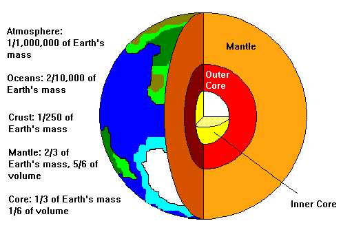
The diagram above shows the main components of the earth:
Solid Earth
- A thin outer layer, the lithosphere, is about 100 km thick. In comparison to the whole earth, it is about as thick as the skin on an apple.
- A thick layer of solid rock, the mantle.
- A central core.
Biosphere
The domain of life, from several kilometers deep in the lithosphere to 10 km or so above the surface.
Hydrosphere
The zone of liquid water on the earth, dominated by the oceans but also including lakes and rivers and liquid underground water.
Cryosphere
The zone of frozen water on the earth, including the Antarctic and Greenland ice caps, glaciers, and permanently frozen ground (permafrost). The cryosphere is often considered part of the hydrosphere.
Atmosphere
- The bottom 10 km or so is the troposphere, from a Greek word for "turning." The sun warms the surface, but warm air rises, and as it rises, it expands and cools. Then the cool air sinks. This constant churning creates the weather.
- Above 10 km or so, the air is too thin for warm air from the surface to continue rising. The next layer, the stratosphere, is stable and stratified, with cold air at the base and warm air above. Because it is so stable, commercial aircraft fly at the lower boundary of the stratosphere. Military aircraft and the supersonic airliner the Concorde fly within the stratosphere. Near the top of the stratosphere, solar ultraviolet causes oxygen to form ozone (O3). Ozone absorbs solar ultraviolet and helps protect the surface.
- From 50-80 km, the temperature of the atmosphere again begins to fall. This layer is the mesosphere. At about 80 km we find the coldest temperatures in the atmosphere, about -95 C. In the mesosphere, solar radiation and particles create electrically charged atoms and this screen of charged atoms absorbs radio signals. However, at night most of the charged atoms recombine with stray electrons and the remaining charged atoms settle into fairly smooth layers that reflect radio signals. This is why at night you can often pick up AM stations a thousand miles or more away.
- Above 80 km temperatures again increase. The air is so thin that atoms are accelerated by sunlight and solar particles. They are moving very fast, so their temperature is very high, but there are so few atoms that a spacecraft passing through this layer, the thermosphere, feels no appreciable heat. The thrmosphere tapers off into space, but traces of atmosphere extend 1000 km or more above the earth.
Solid Earth
Earth Science
- Geology
- Solid Earth Much Larger than Other Parts
- Many More Kinds of Materials
- Preserves a History
- Meteorology – Climatology
- Oceanography
- Astronomy
- Planetary Geology
Earth Systems
- External Effects (Astronomical)
- Atmospheric Circulation
- Oceanic Circulation
- Hydrologic Cycle
- Rock Cycle
- Plate Tectonics
Convection

- Top left: a pot on a stove reaches a rolling boil. Hot water from the bottom rises and very slightly cooler water (not enough to make a difference if you stick your hand in!) sinks.
- Tope center: some lakes reach a point where the surface is cooler than the bottom. When this happens, often in the fall, the lake undergoes a convective overturn. The surface water sinks and the bottom water rises.
- Top right: cumulus clouds on a summer afternoon result from warm air rising, expanding, and cooling, so that clouds condense. In the clear air between, cooler air sinks.
- The same thing can happen in late fall. The surface air can be cool, but upper level air can be very cold. The warmer surface air rises and creates cumulus clouds. The result can be a very dramatic, turbulent-looking sky, but one without any violent weather.
- Bottom left: two scales are represented here.
- Hurricanes are fueled by warm air rising from tropical seas. Cold air rushes in to replace it. Hurricanes generally die out when cut off from their source of heat by crossing land or drifting into colder oceans.
- Hurricane-like storms occur in the Arctic. They are not called hurricanes but have the same spiral structure and even a central eye. The surface water is only 0 C, but the air may be -20C, and the "warm" water supplies energy for the storm. "Warm" is a relative term.
- On a larger scale, the earth's wind belts are driven by warm air rising at the equator and sinking in mid-latitudes.
- Bottom center: Rising material from deep in the earth reaches the surface, moves laterally, and sinks. This process drags large slabs of crust along, driving plate tectonics.
- Bottom right: In the sun and most stars, convection is the final stage in transporting heat from the deeper interior to the surface.
Earth and the Universe
- Rotation (Day-Night)
- Lunar (Tides)
- Annual (Seasons)
- Precession and Orbit Variations (Ice Ages?)
- Galactic (250 m.y. period)
- Unpredictable Events
- Nearby Supernovae
- Meteor Impacts
- Long-Term Evolution of Sun
Atmospheric Circulation
- Unequal Solar Heating
- Equator to Pole
- Day - Night
- Different Surfaces
- Buoyancy
- Adiabatic Heating and Cooling
- Coriolis Effect
- High and Low Pressure
- Fronts and Air Masses
Atmospheric Circulation

- At the equator, warm air rises. Since much of the air movement is vertical, winds are light. This band is the Equatorial Doldrums.
- Warm air above the surface moves poleward and cooler air moves toward the equator. The Coriolis Effect causes this air flow to be deflected to the west. Thus there is a belt of easterly winds on either side of the equator. Because they were so useful for crossing oceans in the days of sailing ships, they are called the Trade Winds.
- Around 30 degrees from the equator, cool air sinks. Again, since much of the air movement is vertical, winds are light. This band is the Horse Latitudes, supposedly because sailing ships becalmed here often had to throw overboard the bodies of horses that died of starvation or thirst.
- Air sinking in the horse latitudes flows equatorward in the Trade Winds and also poleward. The poleward flow is deflected east by the Coriolis Effect, so in mid-latitudes there is a belt of westerly winds, the Westerlies. In the Southern Hemisphere, south of Africa and Australia, there is nothing but ocean around the globe. With nothing to block or divert the winds, they get very intense. These latitudes are called the Roaring Forties.
- Cold air flowing outward from the poles is, like the Trade Winds, deflected westward. This zone is called the Polar Easterlies.
The boundaries between wind belts are not fixed but fluctuate and have wave-like geometries.
A loop like the one from the doldrums to the horse latitudes is called a Hadley Cell.

Oceanic Circulation
Surface Currents
Surface currents, shown below, are driven by the winds. Warm water is red and cold water is blue. The Trade Winds propel ocean water westward along the equator, and when it strikes a continent, it is diverted poleward. However, a narrow return flow also occurs along the equator. In mid-latitudes the currents are driven eastward by the Westerlies. The opposing wind belts cause currents in all the ocean basins to form gyres, or giant loops.

Thermohaline (Deep) Circulation
- Evaporation makes water more saline and denser
- Freezing makes water more saline and denser
- Cold water is denser than warm water

A combination of surface and deep flow creates a giant global heat conveyor. The coldest and densest water forms off Antarctica and flows along the ocean floors until it reaches an obstacle. Then it rises and joins the surface circulation. As water loops around the North Pacific gyre, it becomes extremely warm. Even though the amount of water that passes from the Pacific to the Indian Ocean is not great, the amount of heat it carries is. It cools a bit rounding Africa, then warms in equatorial latitudes and carries water up the Atlantic into the Arctic. Finally the water cools and sinks, mixes with cold bottom water, and begins the cycle again.
Hydrologic Cycle
- Evaporation from Oceans
- Precipitation on Land
- Infiltration into Ground (Ground Water)
- Runoff (Erosion)

Water
- Principal Agent in Modifying Earth’s Surface
- Medium for Storing and Distributing Global Heat
- The Universal Solvent
- Essential for Life
- Destructive to Rocks
- Lowers Melting Point of Rocks
- Reduces Strength of Rocks Under Pressure
The Rock Cycle
- New Rocks Exposed by Erosion
- Rocks Broken Down Mechanically and Chemically (Weathering)
- Components Transported by Erosion
- Components Cemented into Sedimentary Rocks
- Burial and Heating creates Metamorphic Rocks
- Melting Creates Igneous Rocks
Plate Tectonics
- Outer Crust of Earth Moves a Few cm/yr
- Driven by Convection in Earth’s Interior
- Accounts For:
- Earthquakes
- Volcanoes
- Mountain-Building (Orogeny)
- Configuration of Continents
- Configuration of Continents and Mountain Belts Affect
- Oceanic Circulation
- Weather and Climate Patterns
- Deserts Mountains and Rain Shadows
- Pathways for Migration
- Ecological Niches
Return to Earth Science Notes Index
Return to Physical Geology Notes Index
Return to Professor Dutch's home page
Last Update February 28, 1997