Plate Tectonics and Earth History
Steven Dutch, Professor Emeritus, Natural and Applied Sciences, University of Wisconsin - Green Bay
Wilson Cycles
The earth is 30% continental crust. There isn't a great deal of room for pieces to move before they collide. The bigger a continent gets through collisions, the larger a target it becomes and the more likely it is that it will grow still larger through more collisions. Chances are good that a large part of the continental crust will collect in one place as a supercontinent before it begins to break apart. This has happened twice that we know of, and perhaps more times in the distant geologic past. This process of assembly, breakup, dispersal and reassembly takes about 500 million years and is called the Wilson Cycle after the Canadian geologist who first described it.
The Wilson "cycle" has no predictive value, any more than the "hydrologic cycle" can predict rain. It merely says that continents break up and the pieces reassemble, usually not in the same way.
However, there is no rule that says all the continents have to get together. It didn't happen to Pangaea and probably not to Rodinia, the earlier supercontinent.
Why do supercontinents break up? Continental crust is thick, but also brittle. You probably can't move something that big without generating stresses stronger than the crust can handle. In fact, like bad welds, continents seem to like to break apart along previous collision boundaries.
Breakup of Pangaea
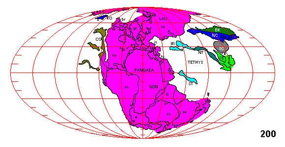
At about 200 million years ago, Pangaea isn't quite Pan-Gaea because China and southeast Asia, as well as portions of Iran and Tibet, have not quite attached.

Just as pieces of China are beginning to attach, Laurasia (North America + Eurasia) breaks away. It is tempting to wonder if the two events might be connected.

Around 130-100 million years ago, Gondwanaland breaks apart. At about 80 million years, North America and Eurasia split apart. Initially Greenland remains attached to Europe but after a few million years it breaks off and thereafter remains part of the North American Plate.

The last major breakup happens at 50 million years when Australia decides it's getting chilly and breaks apart from Antarctica.

The Present Configuration
Assembly of Pangaea
Rodinia

This is as far back as we can see now and it's fairly conjectural at that. Just as Africa was at the center of Gondwanaland, about 750 million years ago North America was probably at the center of a supercontinent that has been named Rodinia.
Assembly of Gondwanaland

Rodinia breaks up about 750 million years ago and most of the component pieces reassemble in a series of collisions to form Gondwanaland over the next 200 million years. Laurentia (the core of North America), Baltica (the core of Europe) and the Siberian shield remain as distinct plates. The accreted terranes of North America are shown off North America but in reality we don't know exactly where they were.

Notice that a number of new pieces have suddenly appeared. We simply have no information on their locations before this time.

North America and Europe collide to form the ancestral northern Appalachians.

North America and Europe then collide with Gondwanaland to form the ancestral southern Appalachians. Also note a piece has merged with Siberia, and Siberia is about to collide with Europe to create the ancestral Urals. Finally, pieces of Asia break away from Gondwanaland.
Finally Pangaea is as assembled as it will ever get.
Closure of the Tethys
The large wedge-shaped seaway between Laurasia and Gondwanaland is almost entirely gone. The Mediterranean is its last remnant. The closure of the Tethys resulted in mountain-building all the way from Spain to Burma. Here are some effects of these events.
The Drying of the Mediterranean
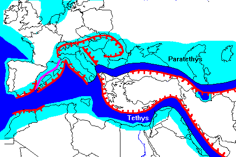 |
The Mediterranean region 20 million years ago. Present coastlines are shown for reference only. Deep water is deep blue and shallow seas are light blue. The exact configuration of pieces making up Greece and Turkey are unknown.
This portion of the Tethys is about to close as Africa and Eurasia converge. However, there would have been no nead of a Suez Canal, and Columbus would not have needed to sail west to try to reach China. |
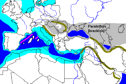 |
By 10 million years ago, plate collisions have sealed off the eastern Mediterranean, trapping small remnants of ocean floor in the Black and Caspian Seas. Mountain barriers in the Balkans seal of a large inland sea, which becomes brackish as salt water is flushed out by river water. |
 |
By 6 million years ago, Spain and Africa collide, raising a mountain barrier and sealing off the western end of the Mediterranean. River inflow is not enough to maintain the level of the Mediterranean, which dries out.
However, rivers flowing to the Mediterranean can cut below Atlantic sea level. Eventually one does, and Atlantic sea water starts flowing in, cutting the Strait of Gibraltar and filling the Mediterranean. |
The Middle East

The Collision of India and Eurasia

 |
At first glance it looks as if India nestled into a pocket specially made for it. In fact, India has profoundly changed the outline of Asia. A simple experiment shows how. If a rigid block is pushed into a soft material like clay, it creates a network of criss-crossing faults ahead of it. Additional pushing causes wedges of clay to be pushed to the side, a process called tectonic extrusion. The bottom diagram looks remarkably like the actual geography of Asia.
To the west of India is the main mass of the Eurasian Plate, with a divergent plate margin and North America beyond that. Crust cannot be pushed easily to the west. But to the east are subduction zones where Asia is overriding the Pacific Plate. Crust can be easily pushed in this direction. |
 |
India has fractured the crust of east Asia into several subplates which have been pushed far to the east and southeast as the collision has progressed. The South China Sea opened as Borneo moved away from China. Also, Japan separated from the mainland, but it is not yet clear whether this was related to the collison of India and Eurasia |
 |
The animation shown at left starts at 60 million years ago. India pushes blocks of Asiatic crust eastward. Continental margin rocks smear along the margin of Southeast Asia, while the northern part of India thrusts beneath Tibet. |
Orogeny and Rivers in the West
Two Mountain Ranges Compared
 |
 |
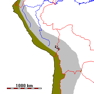
| In the central Andes of Peru and Bolivia, the mountain belt is about 600 km wide at most. The drainage divide between the Pacific watershed (brown) and the Atlantic watershed (gray) is very close to the plate margin. | In the western United States, the mountain belt is well over 1000 km wide and the drainage divide is close to the eastern side of the orogenic belt. There is a large closed interior basin (yellow) created by crustal extension. |
The mountains of western North America are a lot more complex than the Andes for a variety of reasons. The Andes are about as close as one can hope to get to a "theoretical" subduction zone. Terrane accretion in the Andes has been relatively unimportant, whereas half or more of the North American Cordillera has been accreted. Indeed, there is some evidence for tectonic erosion along the Andean subduction zone; South American crust may have been scraped off and carried into the subdution zone (probably to be remelted and added to the igneous arc of the Andes). There are rocks two billion years old near the coast of Peru.
In contrast to the Andes, the Rockies contain numerous block-faulted complexes, especially the ranges of Wyoming like the Wind River, Laramie, and Medicine Bow Ranges. The most widely accepted explanation for why tectonic activity extended so far inland in North America is that the subduction zone that once extended along the entire West Coast had a very flat-dipping slab.
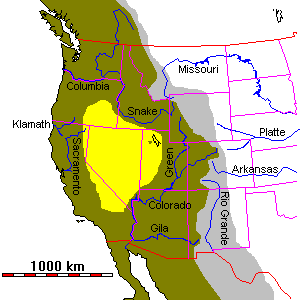
Before the Spreading
Many geologists have argued on the basis of geologic history and topography for great drainage diversions throughout the West. Until recently, these hypotheses, plausible as they may have been, had little chance of confirmation. In recent years, DNA studies on aquatic populations have been used to try to confirm or refute some of these hypotheses.
 |
The map at left is a reconstruction of the Western U.S. about 30 m.y. ago, before the extension of the Basin and Range Province and the opening of the Gulf of California. The Great Basin has been reduced in width by half and Baja California and California west of the San Andreas Fault have been moved southeast to close the Gulf of California.
This sort of map is called a palinspastic map. A palinspastic map corrects for crustal deformation. Maps of this sort were once much more widely used, but many of them were attempts to reconstruct mountain belts that we now know were actually built of disconnected terranes. In the case of this map, no major terranes have been accreted to the West Coast of North America since the time represented here, so the map is at least approximately correct. |
- The ancestral Missouri River, like all major rivers of the northern Plains, flowed northeast across Hudson's Bay (which was then land). The present drainages are all the result of glacial diversion during the Pleistocene.
- DNA studies suggest a former connection between the Green River and the Mississippi drainage system
- Given the other drainage changes on the map, a connection between the upper Colorado and Mississippi systems seems likely. The Platte River serves nicely as a continuation of the Green and upper Colorado Rivers.
- DNA studies suggest a connection between the upper Snake River and the Humboldt-Lahontan drainage of Nevada, which may well also have continued via the Feather River to the Pacific. The drainage almost certainly was not via present San Francisco Bay, which didn't exist until a few million years ago.
- Other DNA studies suggest a connection between parts of the Snake River and the Klamath River of Oregon.
- The lower Colorado probably drained to the Pacific. Voluminous conglomerate deposits near San Diego, otherwise unexplainable, have long been suggested as a former Colorado River delta.
- DNA studies suggest possible connections of the Gila and Little Colorado Rivers to the Rio Grande.
- The sharp bend in the upper Sacramento River basin suggests a probable former connection to the Klamath River as shown.
The drainage diversions in Canada and Mexico are unknown. The Columbia River certainly did not have the course shown. The present river flows along the boundary between the Columbia Plateau volcanic rocks (about 15 m.y. old) and the Cascade highlands. Does the sharp bend in Canada represent diversion of a former north-flowing system?
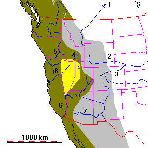
If we reconstruct these drainage diversions, the mountain belt of western North America 30 m.y. ago was much narrower and the continental divide a good deal further west. Although still more complex than the Andes, it looks a lot more similar.
Running the clock still further back, to say 50 m.y. ago, we might surmise that the active mountain building was fairly close to the coast, that the uplifts in Colorado and Wyoming were barely beginning, and that the margin of North America looked a great deal like the present Andes.
Return to Earth Science Notes Index
Return to Physical Geology Notes Index
Return to Professor Dutch's Home Page
Created 14 October 2003, Last Update