Baird Creek Parkway
Steven Dutch, Professor Emeritus, Natural and Applied Sciences, University of Wisconsin - Green Bay
 |
Baird Creek Park Way runs about 5 kilometers along Baird Creek. At its eastern end along I-43 there are exposures of the Maquoketa Formation. The steep valley sides are cut into thick Pleistocene deposits, mostly outwash; during the construction of I-43 there were excellent exposures of glacial features in temporary sand and gravel pits. |
Locality Map
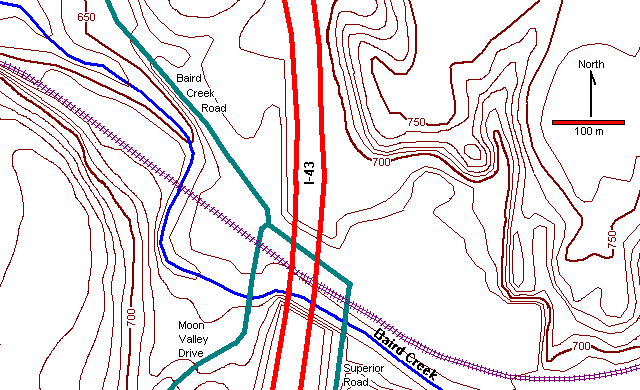
Below, a view looking north along Superior Road. I-43 is to the left, Baird Creek is at the bottom of the valley just before the sharp left turn in Superior Road. The road continues beneath I-43 and thence northwest as Baird Creek Road.

Bedrock Exposures in Baird Creek
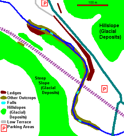 |
At left is a simplified geologic map of the bedrock exposures west of I-43. There are more bedrock exposures than a casual inspection suggests, but many of them are only obvious when the trees are bare.
The outcrops end abruptly and the northwesternmost of them are 5m and more above the level of the stream. This suggests that when the glaciers first melted, and Baird Creek was carrying much more water than at present, there may have been a low waterfall perhaps 5m high flowing over a rock ledge. Since all the rocks are of uniform hardness, the falls would not have retreated as a steep falls but would have stripped away layers piecemeal to create the present stream with numerous low falls and small rapids. |
Slumps in Baird Creek Valley?
 |
East of I-43 is a broad flat meadow surrounded by steep hills. Bordering the meadow is a half ring of hills separated from the adjacent hills by narrow, steep ravines. These hills appear to be slump blocks that dropped away from the original slope.
Judging from the trees on them, the slumps are now stable. They probably occurred either when stagnant ice in the valley melted, resulting in a steep unstable hill front, or perhaps when melt water pouring down the valley eroded and oversteepened the valley walls. |
Return to Geology of Wisconsin Index
Return to Geologic Localities Index
Return to Professor Dutch's Home Page
Created 16 June 1999, Last Update 26 April 2000