Europe 50N 20E
Steven Dutch, Professor Emeritus, Natural and Applied Sciences, Universityof Wisconsin - Green Bay
Scale: 1 pixel = 10 km. 10-degree grid; Lambert Conformal Conic Projection, Center 70N 90W
Legend
Ocean Floor Ages

Tectonic Structures
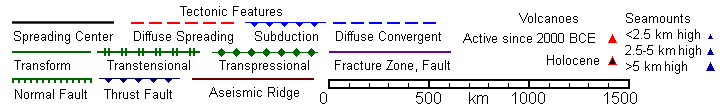
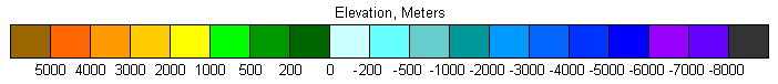
Topography
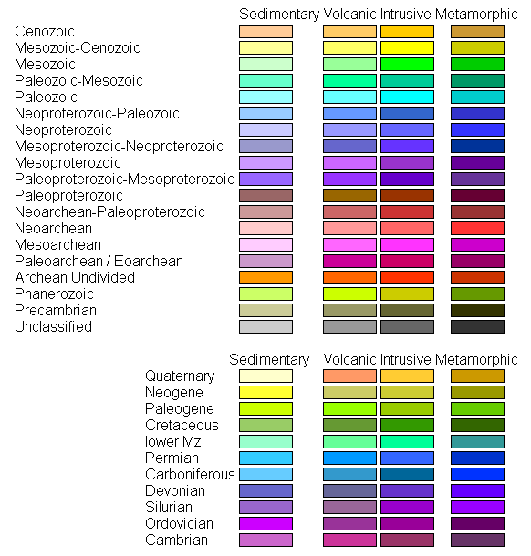
Land Geology
Discussion
Europe consists of a Precambrian shield, the Fennoscandian Shield and its mostly buried extensions into Russia, two Paleozoic orogens, and a mosaic of accreted terranes and microplates in the Mediterranean.
The Paleozoic fold belts are the Caledonian in the northern British Isles and Norway, and the mostly buried Hercyinian in the southern British Isles, France, Spain and parts of Germany. The Caledonian fold belt is early Paleozoic and corresponds to the Taconic orogen in North America. It was split again when Greenland separated from Eurpoe, and the western half is on the eastern coast of Greenland. The Hercynian orogen is later Paleozoic and corresponds to the Appalachian orogen in North America.
Italy, the Balkans and Turkey are a mosaic of multiple microplates, some of which were originally attached elsewhere in Europe and some of which were attached to Africa. The Balearic Islands, Sardinia, Corsica and Calabria (the toe of Italy) are former continuations of the Alps that rifted away from southern France and Spain. Sicily is actually part of the African Plate.
The collision of Africa and Eurasia created the Mediterranean and set the stage for one of the most dramatic events in earth history. Until 10-20 million years ago there was still a remnant seaway between Arabia and Eurasia. That eventually closed by collision, leaving only a seaway between Spain and Africa. That, too closed, and the Mediterranean Basin, with too little river influx to balance evaporation, dried out. However, rivers flowing into the basin were able to cut valleys far below Atlantic sea level. Eventually Atlantic sea water topped a drainage divide and spilled into the basin. There's lots of lurid stuff out there about twenty mile wide waterfalls, but in reality it must have taken some time to fill the basin because there is a thick salt layer beneath the Mediterranean sea floor, and the meager river input during the dry basin phase could not have supplied that much salt. Still, it must have been something to see.
Return to Global Geology Index.htm
Return to Professor Dutch's Home Page
Created 11 April 2014, Last Update 19 January 2020