Moon: South Pole 90S 000EW
Steven Dutch, Natural and Applied Sciences, University
of Wisconsin - Green Bay
e
Scale: 1 pixel = approximately 4.7 km. 10-degree grid; Lambert Azimuthal Equal Area Projection, Center 90S 000EW
Lunar Geology IndexGlobal and Planetary Geology Index
Legend
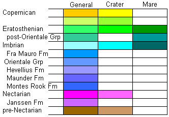 |
Copernican: Beginning with the formation of the
bright crater Copernicus, about 1.1 Ga. Formation of bright ray
craters. Eratosthenian: Begins with the formation of the crater Eratosthenes. Fresh but non-rayed craters and late mare eruptions. 1.1 to 3.1 Ga. Imbrian: Begins with the formation of the Imbrium Basin. Includes most mare eruptions. 3.1 to 3.8 Ga. Nectarian: Begins with the formation of the Nectaris Basin, and includes most of the major impact basin events. 3.8 to 3.9 Ga. pre-Nectarian: Before 3.9 Ga |
Discussion
The south pole of the Moon forms one side of the South Pole-Aitken Basin, and the highest points on the Moon visible from Earth are found on the basin rim near the South Pole. At one time these peaks were called the "Liebnitz Mountains," but that name is no longer in use. Most of this region is light, ancient terra.
The odd swirling pattern around the south pole on the shaded relief maps is an artifact of the computer shading process. Illumination is from the northeast (typical on shaded relief maps) but directions are defined in terms of local coordinates, so the illumination direction changes rapidly close to the pole.
Lunar Geology Index
Global and Planetary Geology Index
Return to Professor Dutch's Home Page
Created 11 April 2014, Last Update
Not an official UW Green Bay site