Channeled scablands: Overview
Steven Dutch, Professor Emeritus, Natural and Applied Sciences, Universityof Wisconsin - Green Bay
Acknowledgement
I need to make it crystal clear that none of this is my own research. The pictures on this and associated pages were taken on a Geological Society of America field trip in 1994 led by Richard B. Waitt of the U.S. Geological Survey, and the interpretations presented here are largely those of Dr. Waitt as presented on the field trip and its guidebook. I thank Dr. Waitt and his colleagues for a stupendous field experience.
Regional Geology
Washington State is an exceedingly complex place geologically, but for purposes of understanding the scablands, it is very simple. There are only two units to consider: resting atop crystalline basement are the Miocene Columbia Plateau flood basalts, about 15 m.y. old. On top of the basalt is loess. The loess was derived from glacial outwash eroded out of the Cascade Range and blown eastward. In eastern Washington are the thickest loess deposits in the United States, up to 100 meters deep. The Scabland channels are cut almost entirely in loess and basalt.
The Pleistocene Cordilleran glaciers covered only northernmost Washington. They floweddown the Puget Lowland and advanced a short distance across the upper ColumbiaRiver in several places.
Flood Basalt Terminology
Columbia basalt flows are divided into two principal zones named after architectural features. The thick columnar part of the flow is called the colonnade,and the upper more massive zone is called the entablature.
 |
The top of this bluff in upper Grand Coulee is the entablature of a flow, with a well-defined colonnade beneath it. Below a thin basal zone is the entablature of the next flow down. |
In the field, the entablature looks highly fractured, and often is, but thefractures are often not penetrative or completely connected. The colonnade, incontrast, has through-going fractures along the length of the columns. Somewhatcounter-intuitively, the entablature is the stronger part of the flow, and whenwe find large flood-borne or glacially transported basalt boulders, they tend tobe from the entablature. Both flood transport and glaciation easily fragment thelong narrow columns. Thus the colonnade tends to be the zone of greatest floodscour. It also tends to be the zone of easiest weathering, and it is fairlycommon to see grottoes where the collonade has weathered away leavingoverhanging entablature.
Flood Landforms
Beginning in 1923, J. Harlan Bretz began arguing that the curious channeledterrain of Washington State was the result of stupendous floods. This idea washighly controversial. It is, of course, easy to bash Bretz's critics inhindsight, until we recall that catastrophist theories are a dime a dozen andare often the lazy way to explain phenomena. In 1925, J.T Pardee suggested thatsudden drainage of a large glacial lake could have supplied the water, but it isnot until the 1940's that he follows this suggestion up with fieldinvestigations.
 |
Bretz realized that many of the features in the scablandswere enormously
scaled up versions of ordinary fluvial landforms.
Many fluid flow phenomena are scale-invariant; they look the same regardless of size. In this photo, there are almost no scale features to indicate whether the river is a few yards or a mile wide. |
 |
Rivers that flow at high speed over rocky beds pluck away weak and jointed bedrock, as here on the upper Penobscot River in Maine. The channel is about 20 meters wide. The bare scoured zone is below the spillway of a dam, and high water discharge keeps the rock free of cover. |
 |
This tract of scabland, small by scablandsstandards, is still over a kilometer wide. The bedrock is columnar basalt, so it eroded differently from the metamorphic rocks above, but the channel has clearly been subject to scour and plucking, resulting in a highly irregular bed. In upper Grand Coulee, where floodwaters scoured through the basalt to underlying granite, the scoured landforms look much like large versions of the scoured channel in the picture above. |
 |
Rivers that flow over unconsolidated material sculpt smoothly curved landforms, like these bars on the Mississippi River above Natchez, Mississippi. |
 |
Loose material carried by the scablandsfloods was likewise sculpted
into streamlined forms, like this small gravel bar which is only 25
meters high, a kilometer or so long and 200 or so meters wide.
The buttes in the left distance are what Bretz called trenched spurs, places where the floods simply rolled over bends in the valley and carved channels through them. The bar was probably deposited as the flood slackened. |
 |
Among the most spectacular landforms are the dry waterfalls carved by the floods. This is famous Dry Falls. |
 |
Dry Falls was a trickle compared to the falls that must have retreated
up upper Grand Coulee. Three small dry horseshoe falls can be seen just
right of the channel bend at right center.
Grand Coulee Dam is at upper right where the river suddenly narrows. Grand Coulee Dam is not in the coulee itself but spans the Columbia River. The lake in the foreground is a reservoir, Banks Lake. |
Why They Call Them "scablands"

|
Looking downstream from Palouse Falls, showing the gorge cut as water spilled over the Snake River drainage divide. The Snake River is a few miles downstream from here. |
 |
Here on the Columbia gorge east of The Dalles near Blalock, the boundary of the loess uplands (light) reveals the high water mark of flooding. The water filled the gorge almost to the brim. |
 |
Nearby, water spilled over a drainage divide 200 meters above the present river with enough force to do this. |
|
|
Looking downstream. The water poured over a narrow ridge separating the Columbia and John Day Rivers, carving this impressive tract of scabland. Only the highest hilltop escaped being submerged. It is still arable because its loess blanket is intact. |
Channel Morphology
Hydraulic modeling has come a long way since Bretz and it is now possible tomodel flow conditions during the floods with some confidence. There tends to bea progression of channel forms with increasing velocity and depth. There is someoverlap in channel form depending on the thickness of the loess.
 |
Floods up to 50 m deep and up to 5 m/sec velocity cut channels in the loess deposits and produce streamlined islands but do not cut into the basalt. |
 |
Floods 50-150 meters deep and moving at 3-8 m/sec strip the loess off the basalt but do not incise deeply. |
 |
Floods 100-250 meters deep and moving 5-25 m/sec produce the classic scabland topography. |
 |
Floods 250-300 meters deep moving 15-25 meters per second or more
carve broad scablands tracts with deep inner channels. 25 meters
per second is over 50 miles an hour.
In this view looking downstream from Dry Falls, almost everything in the picture is scabland. Only a few light strips on the far horizon mark undissected loess. When these floods were at their peak, Dry Falls would have been submerged and scarcely visible. It would have appeared as a somewhat more turbulent part of the flood. Only in the very waning stages of the flood would it have been a spectacular waterfall. Are you getting the numbers here? This is water a thousand feet deep, moving with the force of a fire hose. |
Flood Stratigraphy
Bretz came to realize that there had been at least six floods. More recent workby Waite has identified up to 100, with the earliest and largest separated by50-100 years and the last and smallest by only a few years. It is difficult toimagine excavating something like Grand Coulee with one or a few large floods,however huge, but several dozen make the task more manageable.
Some of the best evidence for flood chronology comes from areas that wereflooded but not scoured. In these relatively quiet areas, backflooddeposits record distinct flood events.
There are other interpretations of the floods. Some workers argue that LakeMissoula alone did not have enough water to flood the scablandsand that anadditional source was necessary. They point to subglacial outbursts from beneaththe Cordilleran Ice sheet, which may have ruptured the ice dam to Glacial LakeMissoula and allowed it to discharge as well.
Hangman Creek

|
At Hangman Creek, just south of Spokane, is an impressive set of backflood deposits. |
 |
Each of the "terraces" in the bank above consists of a relatively durable layer of varved clay overlying sand and gravel deposits from the floods. |
 |
Close-up of a set of varves, indicating a quiet interval of about 21 years between floods. |
 |
Also attesting to the glacial nature of the flooding are occasional dropstones |

|
Close-up of the large dropstone at bottom center of the photo above. |
Burlingame Canyon

|
At Burlingame Canyon west of Walla Walla, an irrigation canal got
out of control in 1926 and carved this section which exposes 39 graded
beds. These are interpreted as backflood deposits from flooding of the
surrounding Pasco Basin.
Backflooding occurred because water could not get through the constriction at Wallula Gap. Wallula Gap is "only" a mile wide. |
Sequence of Events
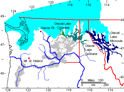
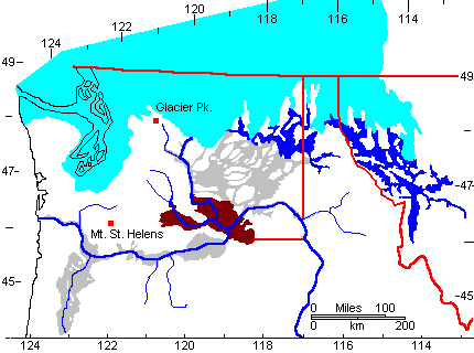
|
During the late Pleistocene, glacial lobes dammed valleys to impound Glacial Lake Missoula as well as smaller Glacial Lakes Spokane and Columbia. Areas flooded by the Missoula floods are shown in gray. |
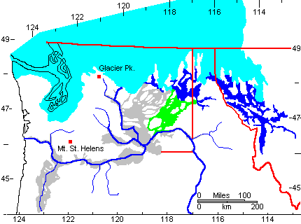
|
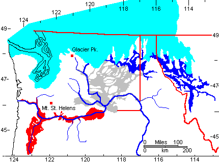
Periodic bursting of the Glacial Lake Missoula ice dam sent water pouring into Glacial Lake Spokane, thence over drainage divides. The earliest and highest floods created the Cheney-Palouse channels (green). |

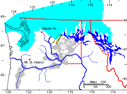
|
Retreat of the ice lowered Glacial Lake Spokane and permitted water to spill over lower drainage divides to create the Telford-Crab Creek channels (yellow). |
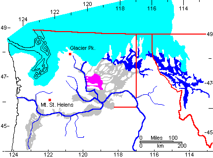
|
Still later floods spilled down Grand Coulee and Moses Coulee (brown). |

|
The last Missoula floods swept down the Columbia River (purple). |
|
The Telford-Crab Creek floods spilled into the Quincy Basin (magenta), flooding it and carving outlets over its drainage divides. |
|
Water then spilled into the Yakima and Pasco Basins (brown), flooding
them. The water could not pass through the narrow constriction at Wallula
Gap and ponded up behind it.
Wallula Gap is "only" a mile wide. |
|
Finally, water surged down the lower Columbia River, flooding tributary valleys including the Williamette Valley (red). |
Geological Society of America Channeled scablandsTrip, 1994
Spokane to Soap Lake
Soap Lake to Chelan
Chelan to Othello
Othello
to The Dalles
The Dalles to Seattle
Geological Society of AmericaGlacial Lake Missoula Trip, 2003
Spokane to Missoula
Missoula to Thompson Falls
Thompson Falls to Spokane
Other Missoula Floods Pages:
Wallula Gap
Frenchman
Coulee
How the Ice Dam Could Have Failed (Animation)
References
HARLEN BRETZ, J, THE LAKE MISSOULA FLOODS AND THE CHANNELED SCABLAND Journal of Gology, Vol. 77, NO 5, P 505-543, SEPT 1969.
Gary A. Smith, Missoula flood dynamics and magnitudes inferred from sedimentology of slack-water deposits on the Columbia Plateau, Washington; Geological Society of America Bulletin; January 1993; v. 105; no. 1; p. 77-100
Richard B. Waitt Case for periodic, colossal joekulhlaups from Pleistocene glacial Lake Missoula Geological Society of America Bulletin; October 1985; v. 96; no. 10; p. 1271-1286
Brian F. Atwater, Periodic floods from glacial Lake Missoula into the Sanpoil Arm of glacial Lake Columbia, northeastern Washington; Geology; August 1984; v. 12; no. 8; p. 464-467
John Shaw, Mandy Munro-Stasiuk, Brian Sawyer, Claire Beaney, Jerome-Etienne Lesemann, Alberto Musacchio, Bruce Rains, and Robert R. Young, The Channeled Scabland; back to Bretz? Geology; July 1999; v. 27; no. 7; p. 605-608
John J. Clague, Rene Barendregt, Randolph J. Enkin and Franklin F. Foit, Jr., Paleomagnetic and tephra evidence for tens of Missoula floods in southern Washington; Geology; March 2003; v. 31; no. 3; p. 247-250; DOI: 10.1130/0091-7613(2003)031<0247:PATEFT>2.0.CO;2 � 2003 Geological Society of America (Geological Society of America)
J Harlen Bretz, Harold Theodore Uhr Smith, and George E. Neff, Channeled scabland of Washington; new data and interpretations; Geological Society of America Bulletin; August 1956; v. 67; no. 8; p. 957-1049
Gerardo Benito, and Jim E. O'Connor, Number and size of last-glacial Missoula floods in the Columbia River valley between the Pasco Basin, Washington, and Portland, Oregon; Geological Society of America Bulletin; May 2003; v. 115; no. 5; p. 624-638; DOI: 10.1130/0016-7606(2003)115<0624:NASOLM>2.0.CO;2
Jim E. O'Connor, and Victor R. Baker, Magnitudes and implications of peak discharges from glacial Lake Missoula; Geological Society of America Bulletin; March 1992; v. 104; no. 3; p. 267-279
Ira Shimmin Allison, New version of the Spokane flood, Geological Society of America Bulletin; August 1933; v. 44; no. 4; p. 675-722
Montana Joseph Thomas Pardee, Unusual currents in glacial Lake Missoula; Geological Society of America Bulletin; November 1942; v. 53; no. 11; p. 1569-1599
Bruce N. Bjornstad, Karl R. Fecht, and Christopher J. Pluhar, Long History of Pre-Wisconsin, Ice Age Cataclysmic Floods: Evidence from Southeastern Washington State; The Journal of Geology, volume 109 (2001), pages 695�713 DOI: 10.1086/323190
Eric V. McDonald, and Alan J. Busacca, Record of pre-late Wisconsin giant floods in the channeled scabland interpreted from loess deposits; Geology August 1988; v. 16; no. 8; p. 728-731
Waitt, R.B., 1994, Scores of gigantic, successively smaller Lake Missoula floods through channeled scabland and Columbia Valley, Chapter 1K in Swanson, D.A. and Haugerud, R.A., eds., Geologic field trips in the Pacific Northwest: (1994 Geological Society of America Annual Meeting), Seattle, University of Washington, 88 p.
Norman B. Smyers1, Roy M. Breckenridge, 2003; Glacial Lake Missoula, Clark Fork ice dam, and the floods outburst area: Northern Idaho and western Montana; Geological Society of America Field Guide 4: Western Cordillera and Adjacent Areas
Return to Historic Sites Index
Return to Virtual FieldTrips Index
Return to Professor Dutch's Home Page
Created 9 April 2003, Last Update 08 June 2020