April 26, 1991: From Incirlik to Zakho
Steven Dutch, Professor Emeritus, Natural and Applied Sciences, University of Wisconsin - Green Bay
Fri 26 Apr
| Moving Out -- Again |  |
 |
We got up at 0430 to load our gear. We had 5 buses and two trucks, so each person had a seat for the trip that turned out to be over 12 hours. After some milling about we left at 0730. |
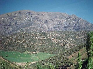
Mountains and Castles
 |
For a few miles we drove through flat farmland, then got into the mountains, after passing two ruined castles. To me, coming back to Turkey was like a trip to the old neighborhood, though I never visited this area during my previous tour. The mountains were spectacular, then the route crossed a broad green valley. |
 |
 |
 |
 |
 |
From the Mountains to the Euphrates
 |
On the other side we drove into hill country with glimpses of snow-capped mountains to the north. We passed Gaziantep; guidebooks say the center of town is interesting but the part along the highway is modern and pretty nondescript. |
 |
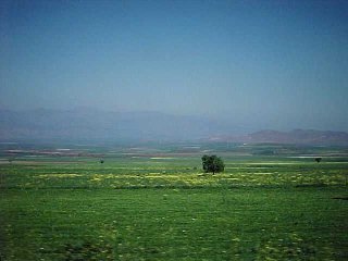
After Gaziantep the country is mostly grassy plateau. |
The Euphrates
 |
We stopped for lunch near Birecik, then crossed the Euphrates. |
 |
 |
We drove through more plateau country, often past fields littered with lava boulders. I was surprised to see mud-brick villages, but the buildings were well-kept and did not convey an impression of degrading poverty. Also surprising was the road. Our impression from the maps we had in Saudi Arabia was that it would take two days to reach our destination from Incirlik, and it would be a real adventure. In fact the road is a nice two-lane paved road with little traffic, and the bus maintains a speed of 50-60 mph.
Into Kurdistan
 |
|
 |
 |
After Kiziltepe, we travel along the Syrian border, at times right along the frontier fence. There are two fences a couple of hundred meters apart, with mine warnings hung from the barbed wire. A few miles to the north the country is mostly buttes and mesas. It is easy to imagine being in Montana or Wyoming. This road, being flat, straight, and through easy country, is an exceedingly ancient route from the Mediterranean to the East.
Along the Syrian Border
 |
|
 |
 |
Toward sunset we saw mountains to the north and east and began encountering convoys. We crossed the Tigris River and entered Silopi. Just beyond the town, a small typical Turkish town, the north side of the road adjoins a huge logistics base. Trucks lined the road for a mile or more. A Turkish military post held a refugee tent settlement with at least 5,000 people. I later heard that many of these were selected influential Kurdish refugees with whom the Turkish government was trying to gain favor. Supposedly, in some cases they were called by name out of mountain camps and resettled.
Approaching the Mountains
There's a weird personal story here. About ten years earlier I published a couple of papers on creationism in the Journal of Geological Education (Now the Journal of Geoscience Education). In the course of researching the story of Noah's Ark, I discovered that the identification of the present Ararat with the Biblical site is actually quite recent, and one prior site claimed for the honor was Jebel Judi in Turkey (Jebel is Arabic for mountain). After realizing the name would now be Turkish, and spelled Cudi Dag, I found it on a map in a far corner of the world I would never see in my life.
Cudi Dag is somewhere in those mountains. I was startled to see a sign bearing the place name Cudi.
 |
 |
 |
 |
 |
The Tigris. We crossed both the Tigris and Euphrates in a single day.
Incidentally, Genesis says that the Garden of Eden was surrounded by four rivers, two of which were the Tigris and Euphrates. That causes most people to assume the story originates in Mesopotamia. But another place the rivers are very close together is near their source in Turkey. |
 |
Silopi. |
 |
 |
About 1800 we got to the border post east of Silopi and could see a range of hills across the border in Iraq. We waited around for our group to assemble and for MAJ Dickson to come by with a truck to lead us into Zakho.
The Border
 |
Our first views of Iraq. |
 |
 |
We crossed the border into Iraq (somebody took down the border sign before any of us had a chance to photograph it in daylight) and almost immediately ran into some Dutch commandos who were astonished that we were coming in at night and without escort. After a somewhat surreal drive in the dark through Zakho, which was still without power because of the war, and several stops for directions, we got to our camp about 2200. The people already at work on the camp had set up a dozen small tents. We rolled our sleeping bags out on the ground inside and went to sleep. During the unloading process I lost my watch, so I had no watch until we returned to Incirlik in June. It was somewhat sobering to find Zakho still without power because of the war, and encounter armed patrols. In Saudi Arabia I had begun to think of the war as long over, but it's not entirely over here.
- August 2, 1990 - January 5, 1991: From the invasion of Kuwait to mobilization.
- January 6, 1991: Departure
- January 7-14, 1991: Settling in at Fort Bragg
- January 15-23, 1991: Fort Bragg Drags On
- January 24 - February 3, 1991: Preparing to Deploy to the Gulf
- February 4 - 5, 1991: Arrival in Country
- February 6-12, 1991: Khobar and Recon to Jubail
- February 13-20, 1991: Al-Jubail
- February 21-25, 1991: Al Jubail
- February 26, 1991: Tapline Road
- February 27, 1991: Return From KKMC
- February 28 - March 3, 1991: We Move Into Kuwait
- March 4 - 8, 1991: On Patrol in Kuwait
- March 9, 1991: The Choke Point
- March 10 - 11, 1991: A Chopper Ride
- March 11, 1991: Chopper Flight - The Oil Fires
- March 12-14, 1991: Oil Fires and Weapons
- March 15-16, 1991: A Congressman and a Private Museum
- March 17-21, 1991: Oil Fires and Routine Patrols
- March 22-24, 1991:Weapons Fire and Day Turns Into Night
- March 25, 1991: Visit to Iraq
- March 27-28, 1991: On the Coast and More Weapons
- March 31, 1991: Easter and Gergian
- April 1-5, 1991: Farewell Dinner and the Sand-Table House
- April 6-7, 1991: Farewell to Kuwait
- April 10-14, 1991: Khobar and Dhahran:
- April 15-16, 1991: Khobar and Bahrain
- April 17 - 23, 1991: Waiting for Kurdistan
- April 24-25, 1991: From Khobar to Incirlik
- April 26, 1991: From Incirlik to Zakho
- April 27-30, 1991: First Days in Kurdistan
- May 1-2, 1991: Camp I Rises
- May 1-2, 1991: Camp I Rises
- May 3-9, 1991: Camp I in Operation
- May 10-13, 1991: The Eventful Birth of Camp II
- May 14-17, 1991: Camp II in Operation
- May 18-19, 1991: Into the Mountains
- May 20, 1991: Kani Masi and Begova
- May 21, 1991: Nazdour and Begova
- May 22, 1991: Uzumlu
- May 23, 1991: Visit to Camp 1 and Nazdour
- May 24-25, 1991: Sirsenk and Silopi
- May 26, 1991: I'll Teach them to Nickname Me "Indy"
- May 27, 1991: Dohuk (Almost) and Kani Masi
- May 28-29, 1991: Return From the Mountains
- May 30, 1991: A Visit From Colin Powell
- May 31 - June 2, 1991: Chopper Flight over Dohuk; Zakho and Silopi
- June 3-7, 1991: Last Days in Kurdistan
- June 6-8, 1991: Incirlik and an Outing Down the Coast
- June 8 - 18, 1991: Out of Turkey and Back to Fort Bragg
- June 19 - October 11, 1991: Picking Up Where We Left Off
Go to Gulf War photo Pages
Go to Gulf War Text Diary
Go to Gulf War Combined photo-Text Pages
Go to 432d Civil Affairs Battalion Page
Return to Professor Dutch's home page
Created January 10, 2000; Last Update 11 June 2020
Created January 10, 2000; Last Update January 10, 2000
Not an Official U.S. Army page